Kuala Lumpur Sentral Station is a transit-oriented development that houses the main railway station of Kuala Lumpur, the capital of Malaysia. Opened on 16 April 2001, KL Sentral replaced the old Kuala Lumpur railway station as the city's main inter-city railway station. KL Sentral is the largest railway station in Malaysia, and also in Southeast Asia from 2001 to 2021, before Krung Thep Aphiwat Central Terminal in Bangkok, Thailand was completed.

Bangsar is a residential suburb on the outskirts of Kuala Lumpur, lying about 4 kilometres (2.5 mi) south-west of the city centre. It is part of the Lembah Pantai parliamentary constituency. Bangsar is administered by Dewan Bandaraya Kuala Lumpur (DBKL), unlike other townships in the Klang Valley such as Petaling Jaya and Subang Jaya which have their municipal councils. Neighbourhood residents' associations and business councils play a part in communicating with the local authority, but they exercise no legal or administrative power. Malays make up most of the population at 61%, followed by the Chinese at 24%, Indians at 15%.

Bandar Utama Damansara is a residential township located within the Sungai Buloh mukim (subdivision) of the Petaling District, Selangor, Malaysia. It is a residential suburb and home to the popular 1 Utama Shopping Centre. Bandar Utama Damansara, together with neighbouring Kampung Sungai Kayu Ara, form the PJU 6 section of the city of Petaling Jaya.
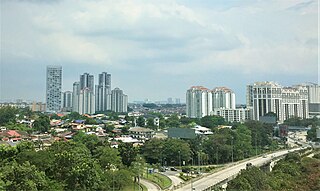
Petaling Jaya, colloquially referred to as "PJ", is a city in Petaling District, in the state of Selangor, Malaysia. Originally developed as a satellite township for Kuala Lumpur, the capital of Malaysia, it is part of the Greater Kuala Lumpur area. Petaling Jaya was granted city status on 20 June 2006. It has an area of approximately 97.2 square kilometres (37.5 sq mi).
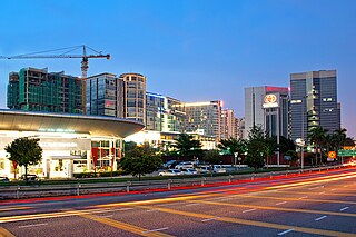
Subang Jaya is a city in Petaling District, Selangor, Malaysia. It comprises the southern third district of Petaling. It consists of the neighbourhoods from SS12 to SS19, UEP Subang Jaya (USJ), Putra Heights, Batu Tiga as well as PJS7, PJS9 and PJS11 of Bandar Sunway, the latter of which are partially jurisdictional within Petaling Jaya under the MBPJ. The city is governed by Subang Jaya City Council (MBSJ), which also governs other areas of the Petaling district, such as Puchong and Seri Kembangan. According to Subang Jaya City Council, Subang Jaya has a population of 968,930 in 2020, which makes it the sixth largest city in Malaysia by population.

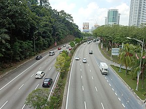
The Damansara–Puchong ExpresswayDamansara–Puchong Expressway, abbreviated as LDP, is a 40.0-kilometre (24.9-mile) major controlled-access highway in the Petaling District of Selangor, Malaysia. The expressway runs in a north–south direction between Bandar Sri Damansara and Putra Permai, near Putrajaya, forming a major thoroughfare in the cities of Petaling Jaya and Puchong. A short east–west spur of the expressway connects Pusat Bandar Puchong to the suburb of UEP Subang Jaya.

Kuala Lumpur Middle Ring Road 2, Federal Route 28, is a ring road built by the Malaysian Public Works Department (JKR) to connect neighborhoods near the boundary of Federal Territory of Kuala Lumpur and Selangor. Altogether, the 65.0 km (40.4 mi) of the entire system consists of Federal Route 28, Damansara–Puchong Expressway Damansara–Puchong Expressway and Shah Alam Expressway Shah Alam Expressway. However, the Kuala Lumpur Middle Ring Road 2 is generally referred to as Route 28 since Route 28 occupies about two-thirds of the system.
The Federal Route 2 is a major east–west oriented federal highway in Malaysia. The 276.9 kilometres (172 mi) road connects Port Klang in Selangor to Kuantan Port in Pahang. The Federal Route 2 became the backbone of the road system linking the east and west coasts of Peninsula Malaysia before being surpassed by the East Coast Expressway E8.

Puchong is a major town and a parliamentary constituency in the Petaling District, Selangor, Malaysia.
Damansara Perdana is an affluent township in Petaling Jaya, Selangor, Malaysia. It is located 20 minutes away from the city of Kuala Lumpur.
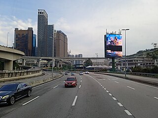
Transport in Greater Kuala Lumpur includes a road network, a railway network, airports, and other modes of public transport. Greater Kuala Lumpur is conterminous with the Klang Valley, an urban conglomeration consisting of the city of Kuala Lumpur, as well as surrounding towns and cities in the state of Selangor. The Klang Valley has the country's largest airport, the Kuala Lumpur International Airport (KLIA), as well as the country's largest intermodal transport hub and railway station, Kuala Lumpur Sentral.

Kampung Sungai Penchala is a small Malay village in the Segambut constituency in northwestern Kuala Lumpur, Malaysia, with the postcode 60000 KUALA LUMPUR, lying along the Federal Territory–Selangor border. This village is next to Taman Tun Dr Ismail in Kuala Lumpur, Malaysia which also shares the same 60000 KUALA LUMPUR postcode, and adjacent to Mutiara Damansara and Bandar Utama that were once part of a large oil palm plantation across the interstate border.
Damansara is a suburb in Petaling Jaya, a mukim in Petaling District, as well as a parliamentary constituency in Selangor, Malaysia. It is named after the Damansara River which flows nearby. It is one of the most densely populated areas in Malaysia. According to the 2000 Census of Malaysia, it was the second-largest district subdivision in Malaysia in terms of population with 453,420 residents.

Greater Kuala Lumpur is the geographical term that determines the boundaries of metropolitan Kuala Lumpur in Malaysia. Though similar to the term "Klang Valley", there remains a variation between the two. The metropolitan area covers 13,565.61 square km of land.

The Malaysian Expressway System is a network of national controlled-access expressways in Malaysia that forms the primary backbone network of Malaysian national highways. The network begins with the Tanjung Malim–Slim River tolled road which was opened to traffic on 16 March 1966, later North–South Expressway (NSE), and is being substantially developed. Malaysian toll road-expressways are built by private companies under the supervision of the government highway authority, Malaysian Highway Authority. While toll-free expressways are built by Malaysian Public Works Department or Jabatan Kerja Raya Malaysia (JKR) in Malay.

Taman Bukit Maluri is a township in Segambut constituency, Kuala Lumpur, Malaysia. This township is located in Kepong adjacent to Menjalara to the south and Segambut to the east.
The Petaling Jaya Dispersal Link Expressway (PDLE) (formerlyKinrara–Damansara Expressway(KIDEX) or KIDEX Skyway) was a new expressway under planning in Klang Valley, Malaysia. The 14.9-kilometre (9.3 mi) expressway connects the Damansara–NKVE Interchange of the New Klang Valley Expressway in the north to Bandar Kinrara in the south. The new expressway was claimed to reduce travelling time between Damansara and Kinrara by about 25%, and reduce traffic volume by 5% in both directions from Puchong to Petaling Jaya. On 16 February 2015, after several protests by the local residents, the KIDEX Skyway project was cancelled by the Selangor State Government. On 2018, the project is revived as Petaling Jaya Dispersal Link Expressway. In 2023, the Malaysian Anti Corruption Commission (MACC) has opened an investigation into improper submission of Social Impact Assessment (SIA). In 2024, Government cancelled due to deadline.

Taman Putra Perdana is a township in Dengkil sub-district, Sepang District, Selangor, Malaysia. Although the township's postcode is 47100 / 47120 / 47130, which gives it Puchong postal address, it is actually in the Sepang constituency of Selangor, administered by the Sepang Municipal Council (MPSepang). The township was developed by Kenshine Corporation in 1997.
The following is an alphabetical list of articles related to Selangor.