Last updated Heavily laden 30 cwt 1533x2 Chevrolets of R1 Patrol of the Long Range Desert Group setting out from Jalo oasis. In the foreground is "R4" Rotowaro W.D.no. L4618912.
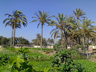
Jalo Oasis (or Jalu, or Gialo) is an oasis in Cyrenaica, Libya, located west of the Great Sand Sea and about 250km south-east of the Gulf of Sidra. Quite large, 19 kilometres (12mi) long and up to 11 kilometres (7mi) wide,[1] it supports a number of settlements, the largest of which is the town of Jalu. Jalu was the administrative capital of the Jalu District from 1983 to 1988, at which time the area became part of the Ajdabiya District and as of 2007 is now part of the Al Wahat District.
Jalu, Jaloo, or Gialo is a town in the Al Wahat District in northeastern Libya in the Jalo oasis. From 2001 to 2007 it was part of Ajdabiya District. Formerly (1983-1987) it was the administrative seat of Jalu District (baladiyah).
In geography, an oasis is the combination of a human settlement and a cultivated area in a desert or semi-desert environment. Oases also provide habitat for animals and spontaneous plants.
Cyrenaica is the eastern coastal region of Libya. Also known as Pentapolis in antiquity, it formed part of the Roman province of Crete and Cyrenaica, later divided into Libya Pentapolis and Libya Sicca. During the Islamic period, the area came to be known as Barqa, after the city of Barca.
Because of its location and as a source of water, it had strategic importance during the North African Campaign in World War II and changed hands several times between Allied and Axis forces.[2]
The North African Campaign of the Second World War took place in North Africa from 10 June 1940 to 13 May 1943. It included campaigns fought in the Libyan and Egyptian deserts and in Morocco and Algeria, as well as Tunisia.
World War II, also known as the Second World War, was a global war that lasted from 1939 to 1945. The vast majority of the world's countries—including all the great powers—eventually formed two opposing military alliances: the Allies and the Axis. A state of total war emerged, directly involving more than 100 million people from over 30 countries. The major participants threw their entire economic, industrial, and scientific capabilities behind the war effort, blurring the distinction between civilian and military resources. World War II was the deadliest conflict in human history, marked by 50 to 85 million fatalities, most of whom were civilians in the Soviet Union and China. It included massacres, the genocide of the Holocaust, strategic bombing, premeditated death from starvation and disease, and the only use of nuclear weapons in war.
The water at the Jalo oasis is quite salty (3,880 parts per million).[3] The water is an alkaline with a pH of 7.4 and is very hard with numerous dissolved salts in addition to sodium chloride.[3]
Salinity is the saltiness or amount of salt dissolved in a body of water, called saline water. This is usually measured in . Salinity is an important factor in determining many aspects of the chemistry of natural waters and of biological processes within it, and is a thermodynamic state variable that, along with temperature and pressure, governs physical characteristics like the density and heat capacity of the water.
Alkalinity is the capacity of water to resist changes in pH that would make the water more acidic. Alkalinity is the strength of a buffer solution composed of weak acids and their conjugate bases. It is measured by titrating the solution with a monoprotic acid such as HCl until its pH changes abruptly, or it reaches a known endpoint where that happens. Alkalinity is expressed in units of meq/L, which corresponds to the amount of monoprotic acid added as a titrant in millimoles per liter.
In chemistry, pH is a scale used to specify how acidic or basic a water-based solution is. Acidic solutions have a lower pH, while basic solutions have a higher pH. At room temperature (25 °C), pure water is neither acidic nor basic and has a pH of 7.
Communities
In addition to Jalu, the oasis supports the following communities:[4]
↑ Reclus, Elisee (1888) Africa: History, Geography, and People: Volume II North-West Africa Appleton, New York, page 25, OCLC9821556
↑ Molinari, Andrea (2006) Desert Raiders: Axis and Allied Special Forces 1940-43 Osprey, Oxford, England, page 74, ISBN978-1-84603-006-2
1 2 Walton, Kenneth (2007) The Arid Zones AldineTransaction, New Brunswick, New Jersey, page 109, ISBN978-0-202-30928-6; originally published by Aldine Publishing Company, Chicago, in 1969, OCLC44718
Hassanein, Ahmed Mohammed (1925) The Lost Oasis Butterworth, London OCLC5663666
Walton, Kenneth (1952) "The Aberdeen University Expedition to Cyrenaica, 1951: Part 2: The oasis of Jalo" Scottish Geographical Magazine 68(3):pp.110–119
OCLC Online Computer Library Center, Incorporated d/b/a OCLC is an American nonprofit cooperative organization "dedicated to the public purposes of furthering access to the world's information and reducing information costs". It was founded in 1967 as the Ohio College Library Center. OCLC and its member libraries cooperatively produce and maintain WorldCat, the largest online public access catalog (OPAC) in the world. OCLC is funded mainly by the fees that libraries have to pay for its services. OCLC also maintains the Dewey Decimal Classification system.
A geographic coordinate system is a coordinate system that enables every location on Earth to be specified by a set of numbers, letters or symbols. The coordinates are often chosen such that one of the numbers represents a vertical position and two or three of the numbers represent a horizontal position; alternatively, a geographic position may be expressed in a combined three-dimensional Cartesian vector. A common choice of coordinates is latitude, longitude and elevation. To specify a location on a plane requires a map projection.
This page is based on this Wikipedia article Text is available under the CC BY-SA 4.0 license; additional terms may apply. Images, videos and audio are available under their respective licenses.
Related Research Articles
The geography of France consists of a terrain that is mostly flat plains or gently rolling hills in the north and west and mountainous in the south and the east.
Awjila is an oasis town in the Al Wahat District in the Cyrenaica region of northeastern Libya. Since classical times it has been known as a place where high quality dates are farmed. From the Arab conquest in the 7th century, Islam has played an important role in the community. The oasis is located on the east-west caravan route between Egypt and Tripoli, and on the north-south route between Benghazi and the Sahel between Lake Chad and Darfur, and in the past was an important trading center. It is the place after which the Awjila language, an Eastern Berber language, is named. The people cultivate small gardens using water from deep wells. Recently, the oil industry has become an increasingly important source of employment.
The Libyan Desert forms the northern and eastern part of the Sahara Desert. It describes that part of the Sahara that lies within the present-day state of Libya; it also historically describes the desert to the south of Ancient Libya, a territory which lay to the east of the present-day state.
The Libyan Desert is one of the driest, harshest and most remote parts of the Sahara, the world's largest hot desert. This extended desert country is barren, dry and rainless.
Tobruk or Tobruck is a port city on Libya's eastern Mediterranean coast, near the border of Egypt. It is the capital of the Butnan District and has a population of 120,000.
Operation Agreement comprised a series of ground and amphibious operations carried out by British, Rhodesian and New Zealand forces on Axis-held Tobruk from 13 to 14 September 1942, during the Second World War. A Special Interrogation Group party, fluent in German, took part in missions behind enemy lines. Diversionary actions extended to Benghazi, Jalo oasis and Barce. The Tobruk raid was a disaster and the British lost several hundred men killed and captured, one cruiser, two destroyers, six motor torpedo boats and dozens of small amphibious craft.
The Western Desert Campaign, took place in the deserts of Egypt and Libya and was the main theatre in the North African Campaign during the Second World War. The campaign began in September 1940 with the Italian invasion of Egypt; Operation Compass, a British five-day raid in December 1940, led to the destruction of the Italian 10th Army. Benito Mussolini sought help from Adolf Hitler, who responded with a small German force sent to Tripoli under Directive 22. The German Afrika Korps was under nominal Italian command but Italian dependency on Nazi Germany made it the dominant partner.
The Battle of Gazala was fought during the Western Desert Campaign of the Second World War, west of the port of Tobruk in Libya, from 26 May to 21 June 1942. Axis troops of the Panzerarmee Afrika consisted of German and Italian units. Allied forces were mainly British, Indian, South African and Free French.
The Murghāb River, also called Margos, Margu and Margiana River, and also transliterated as Murgab and Murgap, is an 850-kilometre (530 mi) long river in Central Asia. It rises in central-western Afghanistan and runs north-west towards the Murghab District, which takes its name from the river. Reaching the oasis of Mary in the Karakum Desert of Turkmenistan, the Murghab mingles its waters with those of the Karakum Canal, a diversion of water from the Amu Darya.
Al Wahat, occasionally spelt Al Wahad or Al Wahah is one of the districts of Libya. Its capital and largest city is Ajdabiya. The district is home to much of Libya's petroleum extraction economic activity.
Operation Salam was a 1942 World War II military operation organised by the Abwehr under the command of the Hungarian desert explorer László Almásy. The mission was conceived in order to assist Panzer Army Africa by delivering two German spies into British-held Egypt.
The Capture of Kufra/Prise de Koufra was part of the Allied Western Desert Campaign during the Second World War. Kufra is a basin and oasis group in the Kufra District of south-eastern Cyrenaica in the Libyan Desert. In 1940, it was part of the colony of Libia Italiana, which was part of Africa Settentrionale Italiana (ASI), which was established in 1934. The battle, resulted in the capture of Kufra by Free French Forces and the British Long Range Desert Group from the Italian and Libyan garrison.
The Battle of El Agheila was a brief engagement of the Western Desert Campaign of the Second World War. It took place in December 1942 between Allied forces of the Eighth Army and the Axis forces of the German-Italian Panzer Army, during the long Axis withdrawal from El Alamein to Tunis. It ended with the German-Italian Panzer Army resuming its retreat towards Tunisia, where the Tunisia Campaign had begun with Operation Torch (8–16 November 1942).
Rashida (Rasceda) is a desert village in the Jalo oasis of the Al Wahat District in the Cyrenaica region in northeastern Libya. It is about 3.7 kilometres (2.3 mi) southwest of the town of Jalu. In 1951, the population was reported as about 600.
Ajdabiya, previously known as Agedabia, is a town in and capital of the Al Wahat District in northeastern Libya. It is some 150 kilometres (93 mi) south of Benghazi. From 2001 to 2007 it was part of and capital of the Ajdabiya District. The town is divided into three Basic People's Congresses: North Ajdabiya, West Ajdabiya and East Ajdabiya.
Jalu Municipality was one of the municipalities (baladiyah) of Libya from 1983 to 1987. It lay in the northeastern part of the country. Its capital was Jalu. From 2001 to 2007 the area was part of Ajdabiya District. As of 2007 it was subsumed within the enlarged Al Wahat District.
Acroma is a town in northeastern Libya in Butnan District, about 28 km west of Tobruk.
The Cyrenaican desert campaign was a military campaign conducted by the Libyan military in the form of hit-and-run attacks against rebel-held towns and oil facilities in the eastern Libyan Desert that began in April 2011, during the Libyan Civil War. The campaign failed in denying anti-Gaddafi forces control of southern Cyrenaica.
The Atiq Mosque is a mosque in the oasis village of Awjila, in the Sahara desert of the Cyrenaica region of eastern Libya. The community dates back to classical times. Since being taken by the Arabs in the seventh century, Islam has always played a central role in the life of Awjila. The 12th-century mosque, the oldest in the region, has unusual conical domes made of mudbrick and limestone that provide light and ventilation.