
Jamalpur District is a district in Bangladesh, part of the Mymensingh Division. It was established in 1978. It has its headquarters in Jamalpur.
Tangail District is a district (zila) in the central region of Bangladesh. In 1969, Tangail mahakuma was separated from Mymensingh district, and a district of the same name as the mahakuma's was created. The district consists of 237 square kilometers of the prior mahakuma and 3177 square kilometers of land acquired from Mymensingh district. It is the largest district of Dhaka division by area and second largest by population. The population of Tangail zila is about 4 million and its area is 3,414.28 square kilometres (1,318.26 sq mi). The main city of the district is Tangail. It is surrounded by Jamalpur District on the north, the Dhaka and Manikganj Districts on the south, Mymensingh and Gazipur on the east, and Sirajganj on the west.

Mymensingh District is a district in Mymensingh Division, Bangladesh, and is bordered on the north by Meghalaya, a state of India and the Garo Hills, on the south by Gazipur District, on the east by the districts of Netrokona and Kishoreganj, and on the west by the districts of Sherpur, Jamalpur and Tangail. Mymensingh is the 8th administrative divisional headquarter and 12th city corporation of Bangladesh. According to Ministry of Public Administration, Mymensingh is ranked 4th in district status. The density of Mymensingh city is 44,458/km2 which is the second most densely populated city in Bangladesh. Mymensingh attracts 25 percent of health tourists visiting Bangladesh. Once known as the largest district of the Indian subcontinent. Mymensingh town is the district headquarters.

The country calling code of Bangladesh is +880.

Bakshiganj is an upazila of Jamalpur District in the Division of Mymensingh, Bangladesh.

Dewanganj is an Upazila of Jamalpur District, Mymensingh Division, Bangladesh. It covers an area of 266.59 km2 (102.93 sq mi).

Jamalpur Sadar is an upazila of Jamalpur District in the Division of Mymensingh, Bangladesh.

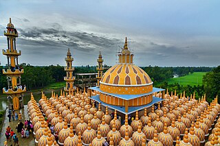
Madarganj is an Upazila in Jamalpur District, in the Division of Mymensingh, Bangladesh.The area is known for its rich cultural heritage, natural beauty, and agricultural productivity.

Melandaha is an upazila of Jamalpur District in the Division of Mymensingh, Bangladesh.

Sarishabari is an upazila of Jamalpur District in the Division of Mymensingh, Bangladesh.
The Jhenai River is located in Bangladesh. It forms as an offshoot of the old channel of the Brahmaputra River, most of the water of which now flows through the Jamuna. The Jhenai bifurcates, with the main branch joining the Jamuna south of Sarishabari in Jamalpur District and another branch flowing south in Tangail District.

Jamalpur Medical College is a government medical college in Bangladesh, established in 2014. It is located in Jamalpur. It is affiliated with University of Dhaka as a constituent college.

Mymensingh Division is one of the eight administrative divisions of Bangladesh. It has an area of 10,485 square kilometres (4,048 sq mi) and a population of 12,225,498 as of the 2022 census. It was formed in 2015 from districts previously composing the northern part of Dhaka Division. Its headquarters are in Mymensingh city in Mymensingh District. Mymensingh has four districts which it governs, Mymensingh District, Jamalpur District, Netrokona District, and Sherpur District.

The Tista Express is a high-speed inter-city train of the Bangladesh Railway, operating between Dhaka and Dewanganj Upazila every day of the week except Monday. It runs from Kamalapur railway station in Dhaka to Dewanganj railway station. The train is a red-green Indonesian air brake. The load of the train is 18/36. This train connects the 3 districts of Dhaka, Mymensingh and Jamalpur on a journey and sometimes Gazipur. Dhaka to Dewanganj train schedule Tista Express takes 5 hours and 10 minutes from Dhaka to Dewanganj.
Jamalpur Zilla School is a public high school in Jamalpur District and one of the oldest schools in Bangladesh.

Jamalpur-2 is a constituency represented in the Jatiya Sangsad of Bangladesh .Since 6 August 2024, The constituency is vacant.

Jamalpur-5 is a constituency represented in the Jatiya Sangsad of Bangladesh since 2024 by Md Abul Kalam Azad of the Awami League.

Jamalpur-1 is a constituency represented in the Jatiya Sangsad of Bangladesh since 2024 by Nur Mohammad of the Awami League.

Jamalpur-3 is a constituency represented in the Jatiya Sangsad of Bangladesh. Since 6 August 2024 the constituency is Vacant.


