
Interstate 64 (I-64) is an east–west Interstate Highway in the Eastern United States. Its western terminus is at I-70, U.S. Route 40 (US 40), and US 61 in Wentzville, Missouri. Its eastern terminus is at the Bowers Hill Interchange with I-264 and I-664 at Bower's Hill in Chesapeake, Virginia. I-64 connects Greater St. Louis, the Louisville metropolitan area, the Lexington–Fayette metropolitan area, the Charleston metropolitan area, the Greater Richmond Region, and Hampton Roads.

The James River is a river in Virginia that begins in the Appalachian Mountains and flows from the confluence of the Cowpasture and Jackson Rivers in Botetourt County 348 miles (560 km) to the Chesapeake Bay. The river length extends to 444 miles (715 km) if the Jackson River, the longer of its two headwaters, is included. It is the longest river in Virginia. Jamestown and Williamsburg, Virginia's first colonial capitals, and Richmond, Virginia's current capital, lie on the James River.
Shunpiking is the act of deliberately avoiding roads that require payment of a fee or toll to travel on them, usually by traveling on alternative "free" roads which bypass the toll road. The term comes from the word shun, meaning "to avoid", and pike, a term referring to turnpikes, which is another name for toll roads. People who often avoid toll roads sometimes call themselves shunpikers. Historically, certain paths around tollbooths came to be so well known they were called "shun-pikes".

The James River and Kanawha Canal was a partially built canal in Virginia intended to facilitate shipments of passengers and freight by water between the western counties of Virginia and the coast. Ultimately its towpath became the roadbed for a rail line following the same course.

West Virginia Route 480 is a 5.64-mile-long (9.08 km) state highway in the U.S. state of West Virginia. Known for most of its length as Kearneysville Pike, the highway extends from WV 115 in Kearneysville north to the Maryland state line at the Potomac River in Shepherdstown, from where the highway continues as Maryland Route 34. The route is one of the main north–south highways of northern Jefferson County and passes through the campus of Shepherd University. WV 480 was originally established in the early 1920s as West Virginia Route 48. The highway was paved in the mid-1920s, which included a different routing through Shepherdstown. WV 48's present routing through the town was established in the late 1930s when the first James Rumsey Bridge was completed; that bridge was replaced with the current bridge in the mid-2000s. WV 48 was renumbered to WV 480 in the mid-1970s after U.S. Route 48 was established in West Virginia and Maryland.

State Route 161 is a primary state highway in and near Richmond, Virginia, United States. It extends from an interchange with Interstate 95 (I-95) in the independent city of Richmond north to an intersection with U.S. Route 1 in the Lakeside area of central Henrico County.

Transportation in the Commonwealth of Virginia is by land, sea and air. Virginia's extensive network of highways and railroads were developed and built over a period almost 400 years, beginning almost immediately after the founding of Jamestown in 1607, and often incorporating old established trails of the Native Americans.

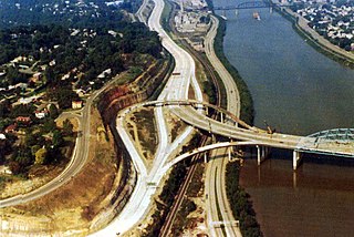
Transportation in Richmond, Virginia and its immediate surroundings include land, sea and air modes. This article includes the independent city and portions of the contiguous counties of Henrico and Chesterfield. While almost all of Henrico County would be considered part of the Richmond area, southern and eastern portions of Chesterfield adjoin the three smaller independent cities of Petersburg, Hopewell, and Colonial Heights, collectively commonly called the Tri-Cities area. A largely rural section of southwestern Chesterfield may be considered not a portion of either suburban area.
Transport in the U.S. state of West Virginia is handled by the West Virginia Department of Transportation (WVDOT) which employs more than 6,000 in West Virginia.

Covington and Ohio Railroad was part of a planned railroad link between Eastern Virginia and the Ohio River in the 1850s. The mountainous region of the Allegheny Front of the Appalachian Plateau between an existing canal, railroads and navigable rivers represented a formidable obstacle.

U.S. Route 52 (US 52) skirts the western fringes of the U.S. state of West Virginia. It runs from the Virginia state line near Bluefield, where it is concurrent with Interstate 77 (I-77), in a general northwest and north direction to I-64 at Kenova. There it turns east, overlapping I-64 for five miles (8.0 km) before splitting off onto the West Huntington Expressway into Ohio via the West Huntington Bridge. Despite having an even number, US 52 is signed north–south in West Virginia. In some other states along its route, it is signed east-west. The West Virginia segment is signed such that US 52 north corresponds to the general westward direction of the highway, and vice versa. For a while, US 52 parallels US 23, which is on the other side of the Big Sandy River in Kentucky. This continues into Ohio, where US 52 travels on the Ohio side of the Ohio River while US 23 travels on the Kentucky side.

U.S. Route 60 (US 60) runs northwest to southeast across the central and southern portions of West Virginia. It runs from the Kentucky state line at Catlettsburg, Kentucky, and Kenova. The road passes through Huntington, Charleston, and White Sulphur Springs. The route exits the state into Virginia, running concurrently with Interstate 64 (I-64) east of White Sulphur Springs. Most of US 60's route through West Virginia is part of and even signed in several areas as the Midland Trail, a National Scenic Byway.
The Charleston Metropolitan Statistical Area, as defined by the United States Census Bureau, is an area consisting of three counties in West Virginia, anchored by the city of Charleston. It is the largest metropolitan area entirely within the state of West Virginia. The Huntington Metro Area adds to the Charleston–Huntington, WV-OH-KY CSA and spans three states, while the core county of the Charleston area, Kanawha County, is more populous than the West Virginia portion of the Huntington area.

Interstate 77 (I-77) in the US state of West Virginia is a major north–south Interstate Highway. It extends for 187.21 miles (301.29 km) between Bluefield at the Virginia state line and Williamstown at the Ohio state line.

Interstate 64 (I-64) is an Interstate Highway in the US state of West Virginia. It travels east–west through the state for 189 miles (304 km) passing by the major towns and cities of Huntington, Charleston, Beckley, and Lewisburg.
U.S. Route 60 (US 60) in the Commonwealth of Virginia runs 303 miles (488 km) west to east through the central part of the state, generally close to and paralleling the Interstate 64 corridor, except for the crossing of the Blue Ridge Mountains, and in the South Hampton Roads area.
The roads of Charleston, West Virginia, include three major interstate highways, several U.S. highways and state routes, and numerous major thoroughfares.
The Staunton–Parkersburg Turnpike was built in what is now the U.S. states of Virginia and West Virginia during the second quarter of the 19th century to provide a roadway from Staunton, Virginia and the upper Shenandoah Valley to the Ohio River at present-day Parkersburg, West Virginia. Engineered by Claudius Crozet through the mountainous terrain, it was a toll road partially funded by the Virginia Board of Public Works. Control of this road became crucial during the American Civil War. Today, the Staunton-Parkersburg Turnpike can be largely traversed by following West Virginia Route 47 east from Parkersburg to Linn, then U.S. Route 33 east through Weston and Buckhannon to Elkins, then U.S. Route 250 southeast through Beverly, Huttonsville, crossing the West Virginia/Virginia state line to Staunton, Virginia.
The Atlantic and Pacific Highway was an auto trail in the United States, essentially eliminated by the U.S. Highway system in the late 1920s. It connected New York City on the Atlantic Ocean with Los Angeles on the Pacific Ocean.

The Appalachian region has always had to allocate much resources and time into transportation due to the region's notable and unique geography. Mountainous terrain and commonly occurring adverse weather effects such as heavy fog and snowfall made roads hazardous and taxing on the traveling vehicles. Initially, European settlers found gaps in the mountains, among them the Cumberland Gap and the Wilderness Road. Another notable challenge of Appalachian travel is the political elements of constructing transportation routes. Most travel systems are funded by municipalities, but since The Appalachian area has several different states it can be difficult for the various governments to agree on how to work on transportation. The most influential forms of travel in the Appalachian region are based on water trading routes, roads and railroads.