
Arrah is a city and a municipal corporation in Bhojpur district in the Indian state of Bihar. The name is also sometimes transliterated as Ara. It is the headquarters of Bhojpur district, located near the confluence of the Ganges and Sone rivers, some 24 mi (39 km) from Danapur and 36 mi (58 km) from Patna.

Dumraon is a nagar parishad city and corresponding community development block in Buxar district in the Indian state of Bihar. Dumraon is one of Bihar's oldest municipalities and one of India's oldest princely states also known as Dumraon Raj. It is located 1.5 km south of National Highway (NH) 84, 20 kilometres (12 mi)north from NH-30 (Patna-Ara-Mohania) and 80 kilometres (50 mi) from NH-2. It is known for its Sinhora. Sights include Jangali Shiv ka Mandir, Bihariji Ka Mandir, Dumrejani mai ka Mandir, Maa Dakshini bhavani ji ka Mandir and Kaliji Ka Mandir. The famous villages near by Dumraon are Purana Bhojpur, Amsari, Baisegaon (Fafadar), Kanjharua, Kopwaon, Koran Sarai, Nandan, Chaugain, Simari, Ariaon & Sowan.udianganj chhatanawar '

Koilwar is a nagar panchayat town and corresponding community development block in Bhojpur district in the Indian state of Bihar. As of 2011, the population of Koilwar town was 17,725, in 2,893 households. It lies on the Arrah-Patna railway route. It is one of the 14 blocks under Bhojpur district.

Bhojpur district is one of the thirty-eight districts of the Indian state of Bihar. Arrah town is the administrative headquarters of this district. Bhojpur district came into existence in 1972. Earlier it was the part of Shahabad district. This district is named "Bhojpur" after great Parmara King Bhoja as most early settlers were Rajput rulers of Parmara dynasty then called as Ujjainiya.
Balua is a village in Bhojpur Ara district in the Indian state of Bihar.
Hetampur is a large village in Jagdispur tehsil of Bhojpur district, Bihar, India.
Ekwari is a village in the Sahar Block of the Bhojpur district and belongs to the Patna division in the Indian state of Bihar.
Harpur Kalan is a small village of 1269 families located in Majorganj, Sitamarhi, Bihar, India. The Harpur Kalan village has a population of 5510 of which 2990 are males while 2520 are females as per Population Census 2011. In Harpur Kalan village the population of children between the ages of 0-6 is 1027, which makes up 18.64% of the total population. The average sex ratio of Harpur Kalan village is 843, lower than the Bihar state average of 918. The child sex ratio for Harpur Kalan as per census is 824, lower than the Bihar average of 935.
Rajepur Nawada is a village in the East Champaran District of Bihar.
Jalpa Chak is a village in Bihar state in India. It is located in Gurua of Gaya district, Bihar with total 147 families residing. The Jalpa Chak village has population of 978 of which 525 are males while 453 are females, according to the 2011 Census of India.

Mokar is a Village located in Sasaram tehsil of Rohtas district in Bihar, India. It is situated 5 km away from Sasaram, which is both district & sub-district headquarter of Mokar village. As per 2009 stats, Mokar village is also a gram panchayat.
Gangdwar is a large village located in Andharthaull Block of Madhubani district, Bihar, India with total 1142 families residing. The Gangdwar village has population of 5293 of which 2831 are males while 2462 are females as per Population Census 2011.
Akauna is a large village located in Sirdala block, Nawada district, Bihar, India.
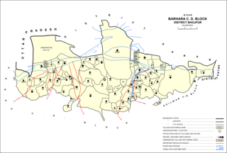
Barhara, also spelled Badahar, Barahara, or Barahra, is a village and corresponding community development block in Bhojpur District of Bihar, India. It is situated on the bank of the river Ganges. By the time of July–August most of the villages under this block are affected by deluge. As of 2011, its population was 6,889, in 927 households, while the total block population was 240,636, in 35,185 households.

Sahār is a village and community development block in Bhojpur district of Bihar, India. The sub-district contains 51 inhabited villages, including that of Sahar itself, with a total district population of 110,276 as of 2011. The village of Sahar has a population of 5,674, in 931 households. Sahar was a major center of conflict during the wider Naxalite insurgency in Bhojpur in the late 1960s and throughout the 1970s.

Udwantnagar is a village and corresponding community development block in Bhojpur district of Bihar, India. As of 2011, its population was 9,000, in 1,496 households. The total block population was 157,809, in 24,336 households.

Charpokhari is a village and corresponding community development block in Bhojpur district of Bihar, India. As of 2011, its population was 1,874, in 314 households. The total block population was 101,363, in 15,961 households.
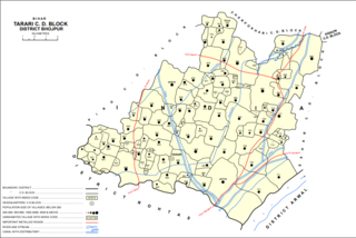
Tarari is a village and corresponding community development block in Bhojpur district of Bihar, India. As of 2011, its population was 3,586, in 393 households. The total block population was 182,631, in 28,316 households.

Agiaon is a village and corresponding community development block in Bhojpur district of Bihar, India. As of 2011, its population was 4,801, in 835 households. The total block population was 148,373, in 23,117 households.

Sandesh is a village and corresponding community development block in Bhojpur district of Bihar, India. As of 2011, its population was 6,874, in 1,037 households. The total block population was 109,712, in 17,011 households.


