Jazán | |
|---|---|
| Country | |
| Region | Amazonas |
| Province | Bongará |
| Time zone | UTC-5 (PET) |
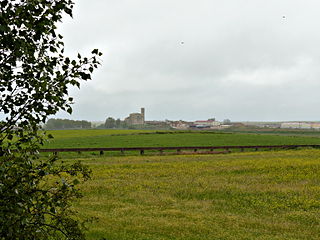
Jazán is a district of Bongará Province, Peru. [1]
Jazán | |
|---|---|
| Country | |
| Region | Amazonas |
| Province | Bongará |
| Time zone | UTC-5 (PET) |
Jazán is a district of Bongará Province, Peru. [1]

The Arctic Archipelago, also known as the Canadian Arctic Archipelago, is an archipelago lying to the north of the Canadian continental mainland, excluding Greenland and Iceland.
The Haines Mountains are a range of ice-capped mountains trending northwest–southeast for about 25 nautical miles and forming the southwest wall of Hammond Glacier, in the Ford Ranges of Marie Byrd Land, Antarctica.

Peque is a municipality in the Colombian department of Antioquia. The population was 7,155 at the 2018 census.

The Ford Ranges are a collection of mountain groups and ranges standing east of Sulzberger Ice Shelf and Block Bay in the northwest part of Marie Byrd Land, Antarctica.
Florida is one of the twelve districts of the Bongará Province in the Amazonas Region of Peru. Its seat is Pomacochas, also named Florida. It is located approximately 90 km from Bagua Grande, at the route of the Peruvian forest for the marginal highway of the forest, today called Fernando Belaunde Terry.
Colcamar is a district of Luya Province in Peru. Colcamar offers several attractive places for tourists like cataracts, ruins of the culture Chachapoya.
Inguilpata is a district in the Luya Province, Perú. Inguilpata is located in the high mountains, it offers several attractive places for tourists such as the ruins of the Chachapoya culture as well as a large variety of crafts are available.
Villanueva de San Mancio is a municipality located in the province of Valladolid, Castile and León, Spain. According to the 2004 census (INE), the municipality had a population of 125 inhabitants.
Lucma District is one of eight districts of the Mariscal Luzuriaga Province in Peru.
Cape Bexley is a headland in the northern Canadian territory of Nunavut. It is located on the mainland, on the south shore of Dolphin and Union Strait, and bounded on the south by Souths Bay. It was named after Nicholas Vansittart, 1st Baron Bexley.
Lagoa do Itaenga is a municipality located in the state of Pernambuco, Brazil. Located 78 km from Recife, capital of the state of Pernambuco. As of 2020, it has an estimated population of 21,460.
Pata is a village on the island of Upolu in Samoa. It is in the political district of A'ana.
The Clare Range is the range extending west-southwest from Sperm Bluff to the Willett Range on the south side of Mackay Glacier, in Victoria Land, Antarctica. It is south of the Convoy Range and north of the Olympus Range.
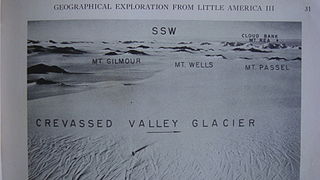
The Denfeld Mountains are a group of scattered mountains between Crevasse Valley Glacier and Arthur Glacier in the Ford Ranges of Marie Byrd Land, Antarctica.
Detour Island is an island lying 2.5 nautical miles (5 km) west of False Cape Renard, on the west side of Lemaire Channel in the Wilhelm Archipelago. It was first charted by the French Antarctic Expedition, 1903–05, under Jean-Baptiste Charcot, and was so named by the UK Antarctic Place-Names Committee in 1959 because the island lies near the entrance to the ships' passage west of Booth Island which provides an alternative route to Lemaire Channel when the latter is blocked by ice.
Granite Harbour is a bay in the coast of Victoria Land, Antarctica, about 14 nautical miles long, entered between Cape Archer and Cape Roberts. It was discovered and named by the British National Antarctic Expedition (BrNAE) of 1901–04 in the Discovery in January 1902, while searching for safe winter quarters for the ship. The name derives from the great granite boulders found on its shores.
Hobbs Ridge is a prominent arc-shaped ridge which circumscribes Hobbs Glacier to the north and northwest and forms the divide with the lower part of Blue Glacier, on the Scott Coast of Victoria Land, Antarctica. It was named in association with Hobbs Glacier. It forms the northernmost part of the Denton Hills.

Mackay Glacier is a large glacier in Victoria Land, descending eastward from the Antarctic Plateau, between the Convoy Range and Clare Range, into the southern part of Granite Harbour. It was discovered by the South magnetic pole party of the British Antarctic Expedition, 1907–09, and named for Alistair Mackay, a member of the party. The glacier's tongue is called Mackay Glacier Tongue. First mapped by the British Antarctic Expedition, 1910–13 and named for Alistair F. Mackay, a member of the party. Its mouth is south of the Evans Piedmont Glacier and the Mawson Glacier. It is north of the Wilson Piedmont Glacier and the Ferrar Glacier.
Lerchenfeld Glacier is a glacier flowing in a west-northwesterly direction between Bertrab Nunatak and the Littlewood Nunataks in Antarctica. It coalesces with the southern flank of Schweitzer Glacier before the combined flow discharges into the head of Vahsel Bay.
| |
|---|---|
| Bagua | |
| Bongará | |
| Chachapoyas | |
| Condorcanqui | |
| Luya | |
| Rodríguez de Mendoza | |
| Utcubamba | |
6°1′S77°55′W / 6.017°S 77.917°W
| | This Amazonas geography article is a stub. You can help Wikipedia by expanding it. |