Leimebamba District

Last updated

Leimebamba
Camp de futbol de Leimebamba des de les escales que pugen al Museu02.jpg
Football field of Leimebamba from the stairs that rise to the museum
CountryFlag of Peru.svg  Peru
Region Amazonas
Province Chachapoyas
Founded3 May 1955
Capital Leimebamba
Government
  MayorLaynes Silva Vigo [1]
Area
  Total373.14 km2 (144.07 sq mi)
Elevation
2,158 m (7,080 ft)
Population
 (2017)
  Total3,620
  Density9.7/km2 (25/sq mi)
Time zone UTC-5 (PET)
UBIGEO 010110

Leimebamba (or Leymebamba) is a district of the province of Chachapoyas, located in the northern Peruvian department of Amazonas, in the valley of the Utcubamba River, about 60 kilometers (37 miles) south of Chachapoyas.

Contents

Geography

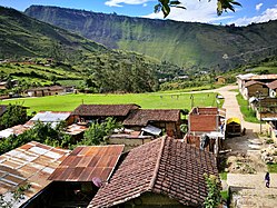
Leimebamba is at approximately 2,000 meters above sea level, and the area is warm with a lush tropical vegetation. Although it can rain anytime of the year, during June to September the weather tends to be dry.

To the north, the Leimebamba District is bordered by San Francisco del Yeso District and Montevideo District, to the east by San Martín Region, to the south by the District of Chuquibamba; and to the west by the District of Balsas.

Leimebamba is located on a mountain near the River Utcubamba.

Villages and hamlets

  • Palmira
  • Leymebamba
  • Bonda
  • Guilipe
  • Muyucsha
  • Ishpingo
  • Pomacochas
  • Cuensol
  • Dos De Mayo
  • Plaza Pampa
  • Chururco
  • Lluy
  • Llushpe
  • Puchicana
  • Checo
  • Teaben
  • Felipa
  • Miraflores
  • Santa Dionisia
  • Gramalote Rural
  • Amuch
  • Parajillo
  • Shalcapata
  • Shishuayco
  • Potrerillo
  • El Salto
  • Triguicsa
  • El Tambo
  • Shonie
  • Monticunga
  • Siogue
  • San Miguel
  • Timbo Yambo
  • Jinez
  • Las Escobas
  • Chorrera
  • Sinuno
  • Lugar Tranquilo
  • Quingrimachay
  • Ñushta
  • Torongil
  • Lajas Bamba
  • Tambillo
  • Shival
  • La Vaquería
  • Monteseco
  • La Joya
  • Tajopamba
  • Quishuar
  • Laguna-C0ndores
  • Churo Churo
  • Corral Conga
  • Pampas Verdes
  • Cabildo Pata
  • Atuen
  • El Jardín
  • Orfedon
  • Israel
  • Chilingote
  • Agua Loca
  • Conjul
  • Chinchango
  • Cashapata

The majority of the villages and hamlets of Leymebamba District are situated in the mountains, some of them are situated near the Utcubamba River.

History

Leimebamba District was legally created on May 3, 1955, during the government of President Manuel A. Odria.

The Incas accompanying Tupac Yupanqui celebrated Inti Raymi in the area, and so named it Raymipampa. From this, the name Leimebamba is derived.

Festivals

Our Lady of Mount Carmel is the patron saint of Leimebamba town, and a festival in her honour is held on July 16 every year. Celebrations include a special mass, a procession, a festival of local cuisine, street parties and fireworks. [2]

August 28, the Day of Saint Augustine sees another celebration.

Transport

There are two overland approaches to Leimebamba. It is located on the main road between Chachapoyas and Cajamarca, all of which is now paved.

Cajamarca has an airport, and from there it is an 8-hour bus ride to Leimebamba, taking in dramatic and ever-changing scenery, as the road, much of which is single-lane, climbs to a 3,200m (10,500 ft) pass after Celendin, then drops to the town of Balsas on the Marañon River at 850m (2,789 ft), before climbing again to the Barro Negro pass at 3,678m (12,068 ft), before descending again to reach Leimebamba (2,200m / 7,218 ft).

It is only 60 km (37 miles) from Chachapoyas to Leimembamba, along the Utcubamba valley, and public transport takes about two hours to make the journey. However, Chachapoyas does not have a commercial airport, with the nearest one being in Jaen, a 4-hour bus journey away.

Tourist Attractions

Leimebamba District is home to a large number of tourist attractions. The best known of these is the Leymebamba Museum, which contains many of the mummies found at the Laguna de los Condores site, along with their funerary offerings. It also has information about the region's flora and fauna, and a display of quipus found in the area.

The spectacular Laguna de los Condores itself can be visited, either by hike or on horseback. There are also many pre-Inca ruins in the region, such as Congona, Petaca and Diablo Wasi, most of which are thought to have belonged to the Chachapoya culture, but have been little studied. Reaching these ruins can be done on foot, with a selection of one-day and multi-day hikes. [3]

The town of Leimebamba has a small selection of accommodation, and can be used as a base to visit other attractions of Amazonas, such as Revash, Kuelap and Gocta Falls.

Religious

Leimebamba is a head office of a parish that is served by two Priests from the Roman Catholic Diocese of Chachapoyas.

6°40′59″S77°46′59″W / 6.68306°S 77.78306°W / -6.68306; -77.78306

Related Research Articles

<span class="mw-page-title-main">Amazonas (Peruvian department)</span> Departments of Peru

Amazonas is a department and region in northern Peru bordered by Ecuador on the north and west, Cajamarca on the west, La Libertad on the south, and Loreto and San Martín on the east. Its capital is the city of Chachapoyas.

<span class="mw-page-title-main">Chachapoya culture</span> Andean culture

The Chachapoyas, also called the "Warriors of the Clouds", was a culture of the Andes living in the cloud forests of the southern part of the Department of Amazonas of present-day Peru. The Inca Empire conquered their civilization shortly before the Spanish conquest in the 16th century. At the time of the arrival of the conquistadors, the Chachapoyas were one of the many nations ruled by the Incas, although their incorporation had been difficult due to their constant resistance to Inca troops.

Jaén, founded as San Leandro de Jaén and then known as Jerez de la Frontera and finally as Jaén de Bracamoros since April 1549, is a city which is the capital of the Jaén Province in the Cajamarca Region in Peru, located in the high jungle of northern Peru. It is the seat of the Catholic Apostolic Vicariate of St. Francis Xavier, also known as Apostolic Vicariate of Jaén en Peru.

<span class="mw-page-title-main">Jauja</span> Town and municipality in Junín, Peru

Jauja is a city and capital of Jauja Province in Peru. It is situated in the fertile Mantaro Valley, 45 kilometres (28 mi) to the northwest of Huancayo, at an altitude of 3,400 metres (11,200 ft). Its population in 2015 was 15,432.

<span class="mw-page-title-main">Chachapoyas, Peru</span> City in Amazonas, Peru

Chachapoyas is a city in northern Peru at an elevation of 2,335 meters (7,661 ft). The city has a population of 32,026 people (2017). Situated in the mountains far from the Peruvian coast, Chachapoyas remains fairly isolated from other regions of Peru. It is served by buses to Chiclayo and Cajamarca, and flights to domestic locations from Chachapoyas Airport.

<span class="mw-page-title-main">Chachapoyas Province</span> Province in Amazonas, Peru

Chachapoyas is a province of the Amazonas Region, Peru. The province of Chachapoyas was a part of the department of Trujillo being its capital the city of Chachapoyas.

<span class="mw-page-title-main">Bongará Province</span> Province

Bongará is a province of the Amazonas Region, Peru. It borders by the north with Condorcanqui Province, by the East with the San Martín Region and Loreto Region, by the south with Chachapoyas Province and by the west with the provinces of Luya and Utcubamba.

<span class="mw-page-title-main">Luya Province</span> Province in Amazonas, Peru

LuyaProvince is located in the south and west part of the Department of Amazonas in Peru.

<span class="mw-page-title-main">Kuélap</span> Archaeological site in Peru

Kuélap or Cuélap is a walled settlement located in the mountains near the towns of María and Tingo, in the southern part of the region of Amazonas, Peru. It was built by the Chachapoyas culture in the 6th century AD on a ridge overlooking the Utcubamba Valley.

Valera is a district of Bongará Province, in the Department of Amazonas, Peru. It includes the villages of San Pablo, Cocahuayco, Cocachimba-La Coca, Nuevo Horizontes and Tingorbamba. The Gocta waterfall, 771 m (2,530 ft) high, is easily accessible from either San Pablo or Cocachimba, which are both accessible by road. The waterfall is a 6 km (3.7 mi). walk on a hiking trail, or by horseback from San Pablo. The capital, San Pablo, is at 1,900 m (6,200 ft) above sea level, and has an idyllic climate. It is lush, with around 1 metre (39 in) of annual rainfall and an average high temperature of 25 °C. It is traversed by the Utcubamba River. It is situated between the cities of Pedro Ruiz Gallo and Chachapoyas.

<span class="mw-page-title-main">Huancas District</span>

Huancas is one of the 21 districts of Chachapoyas Province in the Amazonas Region of northern Peru. It is bounded to the north by Valera District, to the east by Sonche District, to the south by Chachapoyas District, and to the west by Luya District and Lámud District.

<span class="mw-page-title-main">Magdalena District, Chachapoyas</span> District in Amazonas, Peru

Magdalena is a district of the province of Chachapoyas in the Amazonas Region of Peru.

Soloco is one of twenty-one districts of Chachapoyas Province, in Peru.

<span class="mw-page-title-main">Cocabamba District</span> District in Amazonas, Peru

Cocabamba is a district of the province of Luya in the Amazonas Region of Peru.

<span class="mw-page-title-main">Santo Tomás District, Luya</span> District in Amazonas, Peru

Santo Tomás is one of 23 districts of the province of Luya in the Amazonas region of Peru. Santo Tomás is located in the mountains and can have a severe climate. The Saint Tomás region has beautiful cataracts and several ruins of the Chachapoya culture.

<span class="mw-page-title-main">Choquequirao</span> Archaeological site in Peru

Choquequirao is an Incan site in southern Peru, similar in structure and architecture to Machu Picchu. The ruins are buildings and terraces at levels above and below Sunch'u Pata, the truncated hill top. The hilltop was anciently leveled and ringed with stones to create a 30 by 50 m platform.

<span class="mw-page-title-main">Revash</span> Funerary complex in Luya Province, Peru

The Revash funerary complex is located in Peru's Santo Tomás District, part of Luya Province, which is approximately 60 km to the south of Chachapoyas. The funeral buildings are located at an altitude of 2,800 m above sea level. They are within the calcareous rock formation of Cerro Carbón, located in the margin left side of the vale of Alto Utcubamba. The San José de Laumar River serves as the Southeastern border.

Laguna de las Momias, also known as Laguna de los Cóndores is an archaeological site located in Leimebamba, Chachapoyas province, in the Amazonas Region of Peru, excavated by the archaeologist Federico Kauffmann Doig. The site is called Lagoon of the Condors because the people who found the lagoon would see these birds soar near the lagoon; it also obtained the name Lagoon of the Mummies because of the mummy findings around the area. The Chachapoyas were an old civilization that was located in the northern forest in the time of 900 a.c. This culture had been unknown by archaeologists for hundreds of years until the mummies appeared.

<span class="mw-page-title-main">2021 Northern Peru earthquake</span> 2021 earthquake in Peru

A major earthquake struck northern Peru on November 28, 2021, 5:52 a.m. local time with a magnitude of 7.5 on the moment magnitude scale between the Amazonas and Loreto departments of Peru. A maximum Modified Mercalli intensity (MMI) of VII was reported in the town of Santa Maria de Nieva according to the Geological Institute of Peru.

References

  1. "INFOgob". www.infogob.com.pe. Retrieved September 19, 2016.
  2. DePeru.com. "16 de julio – Fiesta Patronal de la Virgen del Carmen en el distrito de Leymebamba (Amazonas)". www.deperu.com. Retrieved September 19, 2016.
  3. "Leymebamba Hiking" . Retrieved September 19, 2016.
  4. Orden de Agustinos Recoletos Archived April 1, 2016, at the Wayback Machine .