Jumbilla | |
|---|---|
| Country | |
| Region | Amazonas |
| Province | Bongará |
| Time zone | UTC-5 (PET) |
Jumbilla is a district of Bongará Province, Peru. [1]
Jumbilla | |
|---|---|
| Country | |
| Region | Amazonas |
| Province | Bongará |
| Time zone | UTC-5 (PET) |
Jumbilla is a district of Bongará Province, Peru. [1]

Elmwood Township is a charter township of Leelanau County in the U.S. state of Michigan. The population was 4,892 at the 2020 census, making it the largest township in Leelanau County by population. The southeasternmost township of Leelanau County, Elmwood Township is suburbanized, as it is immediately adjacent Traverse City, the largest city in Northern Michigan.
Lyford South is an unincorporated community in Willacy County, Texas, United States. It was formerly classified as a census-designated place (CDP). The population was 172 at the 2000 census.
Low Moor is a census-designated place (CDP) in Alleghany County, Virginia. The population was 258 at the 2010 census.
Whitewater is a town in Walworth County, Wisconsin, United States. The population was 1,433 at the 2020 census.

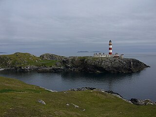
Eilean Glas is a peninsula of Scalpay in the Outer Hebrides, Scotland. Eilean Glas is home to a historic lighthouse. Eilean Glas means Grey/Green Island in Gaelic.

Bongará is a province of the Amazonas Region, Peru. It borders by the north with Condorcanqui Province, by the East with the San Martín Region and Loreto Region, by the south with Chachapoyas Province and by the west with the provinces of Luya and Utcubamba.
Sarecta was the first incorporated town in Duplin County, North Carolina, established in 1787. In 1736, Duplin County was the destination of several hundred Ulster Scots (Scotch-Irish) and a handful of Swiss Protestants. They settled on a plot of land, 71,160 acres between the N. E. Cape Fear River and Black River, obtained from the Crown by Henry McCulloh Esq. of London. Their first settlements were Soracta (Sarecta) on the Northeast Cape Fear, an area at the lower end of Goshen Swamp, and the grove where the Duplin County Courthouse now stands.

KROO was a radio station with a news/talk format, licensed to Breckenridge, Texas.

Baños de Montemayor is a spa town located in the north of the province of Cáceres, Extremadura, Spain. The village is known for its Roman-built baths. According to the 2017 census (INE), the village has a population of 774 inhabitants. Baños is located in the Ambroz Valley.
Bretzville is an unincorporated community in Jackson Township, Dubois County, in the U.S. state of Indiana.
Nash is an unincorporated community in Nelson County, Virginia, United States.

Stac Levenish or Stac Leibhinis is a sea stack in the St Kilda archipelago in Scotland. Lying 2.5 kilometres off Village Bay on Hirta, it is part of the rim of an extinct volcano that includes Dùn, Ruaival and Mullach Sgar.
Powellton is an unincorporated community located in Brunswick County, Virginia.
Chestnut Oaks is an unincorporated community in Powhatan County, in the U.S. state of Virginia.
The Rolling River First Nation is an Ojibwe First Nations community in Manitoba, located south of Riding Mountain National Park.
"Rajaolibanda Diversion Scheme" or "RDS" is an irrigation project located across River Tungabhadra in Jogulamba Gadwal district of Telangana, Kurnool district of Andhra pradesh and Raichur district of Karnataka. It is an inter-state barrage on the Tungabhadra river to supply water to Karnataka, Telangana and Andhra Pradesh states. The full reservoir level of this project is 332.32 m MSL.

KREI is a radio station licensed to Farmington, Missouri, United States. The station airs a News-Talk format, and is currently owned by Alpha Media, through licensee Alpha Media Licensee LLC.
Pargua is a village in the commune of Calbuco, in Los Lagos Region of Chile. It is located on the northeast side of the Chacao Channel. Pargua is on Route 5 and a ferry connects the village with the village of Chacao, Ancud Comuna at the northern end of Chiloé Island. There are plans to build the Chacao Channel bridge across the channel to replace the ferry.
Sundale is an unincorporated community in Muskingum County, in the U.S. state of Ohio.
Lawrence is an unincorporated community in Whatcom County, in the U.S. state of Washington.
5°51′27″S77°47′32″W / 5.85750°S 77.79222°W