The Regional Transportation District, more commonly referred to as RTD, is the regional agency operating public transit services in eight out of the twelve counties in the Denver–Aurora combined statistical area in the U.S. state of Colorado. It operates over a 2,342-square-mile (6,070 km2) area, serving 3.08 million people. RTD was organized in 1969 and is governed by a 15-member, publicly elected Board of Directors. Directors are elected to a four-year term and represent a specific district of about 180,000 constituents.

The 16th Street Mall is a pedestrian and transit mall in Denver, Colorado that opened in 1982. The mall, 1.25 miles long, runs along 16th Street in downtown Denver, from Wewatta Street to the intersection of 16th Avenue and Broadway. The intricate granite stone sidewalks and streets were designed by architect I.M Pei to resemble the scale pattern of the western diamondback rattlesnake. It is home to over 300 stores, 50 restaurants, and the Denver Pavilions shopping mall. In April 2022, construction started on a $149-million multi-year rebuild of the 40-year-old infrastructure, expected to finish in late 2024.

Colfax at Auraria station is a light rail station in Denver, Colorado, United States. It is served by the D and H Lines, operated by the Regional Transportation District (RTD), and was opened on October 8, 1994. It serves the eastern side of the Auraria academic campus, home to Metropolitan State College of Denver, the Community College of Denver, and the University of Colorado Denver.

Littleton–Downtown station is a RTD light rail station in Littleton, Colorado, United States. Operation as a light rail station began on July 14, 2000, with both bus and light rail run by the Regional Transportation District. The station initially saw service on the C Line and D Line, however C Line service ended in 2021. Today the station is only served by the D Line.

Arapahoe at Village Center station is a light rail station in Greenwood Village, Colorado, United States. It is served by the E and R Lines, operated by the Regional Transportation District (RTD), and was opened on November 17, 2006. In addition to numerous office buildings and corporate campuses, the station is the destination for people attending concerts at the Fiddler's Green Amphitheatre. The station also serves as the terminus for the SkyRide AT bus route, with service to Denver International Airport, and is also served by the Bustang Denver Technology Center (DTC) service. The station features a public art installation of a trio of sculptures entitled Nucleus. It was created by Michael Clapper and dedicated in 2010.
The W Line, also called the West Rail Line, is a light rail line in Denver, Lakewood, and Golden, Colorado, United States. The W Line was the first part of FasTracks to break ground, on May 16, 2007. The line, the only line to traverse the West Corridor, opened for service on Friday, April 26, 2013.

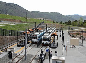
Red Rocks College is an at-grade light rail station on the W Line of the RTD Rail system. It is located alongside 6th Avenue at its intersection with Arbutus Drive in Lakewood, Colorado. The station is located approximately 1⁄2 mile (0.8 km) to the north of the Red Rocks Community College campus, after which the station is named.

Federal Center is an at-grade light rail station on the W Line of the RTD Rail system. It is located near the intersection of West 2nd Place and Routt Street, on the grounds of the Denver Federal Center, after which the station is named, in Lakewood, Colorado.
Oak is an at-grade light rail station on the W Line of the RTD Rail system. It is located near the intersection of West Colfax Avenue and Oak Street, after which the station is named, in Lakewood, Colorado. The station is located within the Lakewood Industrial Park.

Garrison is an at-grade light rail station on the W Line of the RTD Rail system. It is located near the intersection of West 13th Avenue and Garrison Street, after which the station is named, in Lakewood, Colorado.

Lakewood–Wadsworth is an elevated light rail station on the W Line of the RTD Rail system. It is located alongside West 13th Avenue on a bridge over Wadsworth Boulevard, in Lakewood, Colorado, after which the station is named.

Decatur–Federal is an at-grade light rail station on the W Line of the RTD Rail system. It is located alongside the banks of the Lakewood Gulch between its intersections with Decatur Street and Federal Boulevard, after which the station is named, in Denver, Colorado. The station is located in the Sun Valley neighborhood, near the point where Lakewood Gulch meets the South Platte River. It is one of two light rail stops that serve Empower Field at Mile High, the home stadium of the Denver Broncos. The stop is adjacent to Rude Park.

40th & Colorado station is a Regional Transportation District (RTD) commuter rail station on the A Line in the Elyria-Swansea neighborhood and adjacent to the Park Hill neighborhood of Denver, Colorado. The station is the second eastbound station from Union Station in Downtown Denver and fifth westbound from Denver International Airport. About nine minutes from Union Station and 28 minutes from Denver Airport station.

Peoria station, also known as Peoria/Smith station, is a Regional Transportation District (RTD) station in Aurora, Colorado. The station is served by the A Line, a commuter rail line from Union Station in Downtown Denver to Denver International Airport, and the R Line, a light rail line crossing through Aurora and South to Lone Tree. A Line travel times from the station to Downtown Denver and Denver International Airport are about 17 and 20 minutes, respectively. Peoria station is the northern terminus of the R Line with a travel time of 58 minutes to the southern terminus at Lincoln station.

61st & Peña station is a Regional Transportation District (RTD) commuter rail station on the A Line in Denver, Colorado. The station, accessible from Tower Road is located along Peña Boulevard, the sixth eastbound station from Union Station in Downtown Denver and first westbound from Denver Airport. It is about 28 minutes from Union Station and nine minutes from Denver Airport. 61st Avenue provides access from Tower Road to the station.

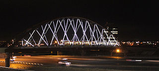
Colfax station is a Regional Transportation District (RTD) light rail station on the R Line in Aurora, Colorado. The station is located on the light rail bridge elevated above Colfax Avenue between Fitzsimons Parkway and Interstate 225.

Fitzsimons station is a Regional Transportation District (RTD) light rail station on the R Line in Aurora, Colorado. The station is located along the north side of Fitzsimons Parkway along Sand Creek Park and serves the University of Colorado Anschutz Medical Campus via a free shuttle bus.

13th Avenue station is a Regional Transportation District (RTD) light rail station on the R Line in Aurora, Colorado. The station is located alongside Interstate 225, a few blocks west of intersection of 13th Avenue and Sable Boulevard. It has a 262-stall park-and-ride lot and is planned to be the center of a transit-oriented development.

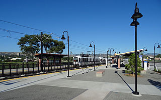
Arvada Ridge station is a Regional Transportation District (RTD) commuter rail station on the G Line between Denver Union Station and Wheat Ridge, Colorado. The station is located in western Arvada, Colorado, on the west side of Kipling Parkway and near Red Rocks Community College's Arvada campus. It includes bus bays, a 200-stall park and ride, and a pedestrian underpass connecting the platform to Ridge Road and the park and ride. Public art at the station includes "Chromatic Harvest", a kaleidoscopic mural wall with geometric imagery of agriculture. The station opened on April 26, 2019.