
Saaremaa(also called Ösel [ˈøːsel] ) is the largest and most populous island in Estonia. Measuring 2,673 km2 (1,032 sq mi), its population is 31,435. The main island of the West Estonian archipelago, it is located in the Baltic Sea, south of Hiiumaa island and northwest of the Gulf of Riga. The administrative centre of the island, and of the Saare County, is the town of Kuressaare, which in January 2018, had 13,276 inhabitants.

Samsø is a Danish island in the Kattegat 15 kilometers (9.3 mi) off the Jutland Peninsula. Samsø is located in Samsø municipality. The community has 3,724 inhabitants (2017) called Samsings and is 114 km² in area. Due to its central location, the island was used during the Viking Age as a meeting place. The etymology of the island's name is unknown.

Frederiksværk is a town with a population of 12,864 in Halsnæs Municipality on Zealand in Region Hovedstaden in Denmark.

Billund Municipality is a kommune in the centre of the Jutland Peninsula in Denmark. Formerly the municipality belonged to Ribe County. The new, merged municipality covers an area of 540.18 km², and has a total population of 27,119 (2024). Its mayor is Stephanie Storbank, a member of Venstre political party. The site of its municipal council is the town of Grindsted, which is the largest town in the municipality followed by the city of Billund.
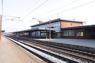
Brørup is a railway town, with a population of 4,554, in Vejen Municipality, Region of Southern Denmark in Denmark. It is located 10 km west of Vejen, 26 km northeast of Ribe, 33 km west of Kolding, 40 km south of Grindsted and 43 km east of Esbjerg.
Ribe is a town in south-west Jutland, Denmark, with a population of 8,295 (2024). It is the seat of the Diocese of Ribe. Until 1 January 2007, Ribe was the seat of both a surrounding municipality and county. It is now part of the enlarged Esbjerg Municipality in the Region of Southern Denmark. It is the oldest town in Denmark.

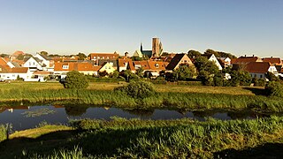
Rødding is a town with a population of 2,783 in Southern Denmark. It is located in Vejen municipality in Region of Southern Denmark on the Jutland peninsula.

Larvik is a municipality in Vestfold county, Norway. It is located in the traditional district of Vestfold. The administrative centre of the municipality is the city of Larvik. Other main population centres in the municipality include the town of Stavern and the villages of Gjone, Helgeroa, Hem, Kjose, Kvelde, Nevlunghavn, Skinmo, Svarstad, Ula, Verningen, and Tjøllingvollen.

Giżycko is a town in northeastern Poland with 28,597 inhabitants as of December 2021. It is situated between Lake Kisajno and Lake Niegocin in the region of Masuria, within the Warmian-Masurian Voivodeship. It is the seat of Giżycko County.

Sölvesborg is a locality and the seat of Sölvesborg Municipality in Blekinge County, Sweden with 10,024 inhabitants in 2013.

The province of L'Aquila is the largest, most mountainous and least densely populated province of the Abruzzo region of Italy. It comprises about half the landmass of Abruzzo and occupies the western part of the region. It has borders with the provinces of Teramo to the north, Pescara and Chieti to the east, Isernia to the south and Frosinone, Rome and Rieti to the west. Its capital is the city of L'Aquila.

Slagelse is a town on Zealand, Denmark. The town is the seat of Slagelse Municipality, and is the biggest town of the municipality. It is located 15 km east of Korsør, 16 km north-east of Skælskør, 33 km south-east of Kalundborg and 14 km west of Sorø.

Ajloun, also spelled Ajlun, is the capital town of the Ajloun Governorate, a hilly town in the north of Jordan, located 76 kilometers north west of Amman. It is noted for its impressive ruins of the 12th-century Ajloun Castle.

Ryn is a town in northeastern Poland located 19 km (12 mi) southwest of Giżycko, in the Warmian-Masurian Voivodeship, in Masuria. Until the reorganization of 1999 it had been assigned to Suwałki Voivodeship. It had a population of 3,062 inhabitants as of December 31, 2004.

The Kongeå is a watercourse in Southern Jutland in Jutland, Denmark. It rises southeast of Vejen and Vamdrup and after about 50 kilometres (31 mi) it flows through a sluice to tidal mudflats and sandbanks north of Ribe, and eventually into the North Sea. The eastern section is little more than a stream, while the western section is navigable by boat as far as the sluice. The Kongeå, however, passes no port or market town of any significance, and small boats use the Ribe Å.

Triangle Region Denmark is a cooperation consisting of seven Danish municipalities on the Danish peninsula of Jutland and the island of Funen: Billund, Fredericia, Haderslev, Kolding, Middelfart, Vejen and Vejle.
Vojens is a railway town in Denmark with a population of 7,545. It was the main town of the now abolished Vojens Municipality, now the second largest town of Haderslev Municipality in Region of Southern Denmark.

Grenaa is a Danish town and seaport on the east coast of the Jutlandic peninsula. Tourism, education and commerce are important sectors in the economy of Grenaa. It is the only larger town on Djursland. Grenaa is the municipal seat, and the largest town, in Norddjurs Municipality, which covers the northern half of Djursland.

Ryomgård is a Danish country town with a population of 2,729 located 29 kilometers north east of to the country’s second largest city Aarhus. As such Ryomgård is in part a pendler town to Aarhus.

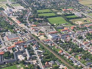
Lunderskov is a railway town, with a population of 2,994, in Kolding Municipality, Region of Southern Denmark in Denmark. It is situated 13 km west of Kolding, 8 km north of Vamdrup and 12 km east of Vejen.


