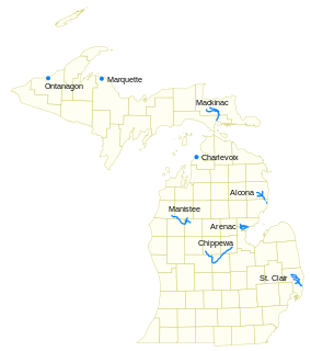
Pine River may refer to any of the following streams in the U.S. state of Michigan:
- Pine River. The main branch forms with the confluence of the East and West Branches of the Pine River at 44°29′38″N83°23′16″W in Alcona County. The South Branch joins approximately 1.5 miles (2.4 km) to the south and flows into Iosco County, where it empties into Van Etten Lake at 44°29′38″N83°23′16″W northwest of Oscoda.
- Pine River. The main branch is formed by the confluence of the North and Middle Branches northeast of Standish and flows into the Saginaw Bay of Lake Huron at 43°58′32″N83°51′16″W. The South Branch Pine River joins the main stream at 43°59′08″N83°53′17″W.
- Pine River is a short waterway, which along with Round Lake, connects Lake Charlevoix with Lake Michigan at Charlevoix.
- Pine River rises in Chippewa County and flows south through Mackinac County into the St. Martin Bay of Lake Huron at 46°03′09″N84°39′22″W The North Pine River, also known as the North Branch Pine River, joins at 46°12′20″N84°36′17″W. Another tributary, Hemlock Creek, is also known as Pine River.
- Pine River, also known as the South Branch Manistee River, rises in southeast Wexford County, flows southwest across northwest Osceola County, then west and north through the northeast corner of Lake County and back into southwest Wexford County, emptying into the Tippy Dam Pond on the Manistee River at 44°13′37″N85°54′27″W. The main stream is formed from the confluence of the East Branch Pine River with the North Branch Pine River at 44°06′02″N85°31′40″W. Another tributary, the Spaulding Creek, is also known as the Little Pine River
- Pine River, in Marquette County, is a very short stream draining Pine Lake into Lake Superior at 46°53′27″N87°52′13″W, north of the Huron Mountains.
- Pine River rises in from Pine Lake in eastern Mecosta County, flows mostly south and east through Isabella County, then south along eastern edge of Montcalm County, then east and north through Gratiot County and Midland County, emptying into the Chippewa River at 43°36′06″N84°17′33″W, just about two miles before it joins the Tittabawassee River near Midland. The South Branch Pine River joins the main stream at 43°30′37″N85°00′02″W Another tributary, Miller Creek, is also sometimes known as Pine River or the West Branch Pine River. The North Branch Pine River joins the main stream at 43°26′03″N84°50′18″W.
- Pine River empties into the St. Clair River at 42°49′13″N82°29′08″W on the south side of St. Clair. The South Branch Pine River joins the main stream at 42°58′11″N82°37′10″W. Another tributary, Quakenbush Drain, is also sometimes known as Pine River.
- Pine Creek empties into Lake Superior and is also known as the Pine River.
Pea Ridge is an unincorporated community in Washington County, North Carolina, United States, on the south side of the Albemarle Sound near the Albemarle Sound Bridge.
Ingleside is an unincorporated community in northern Franklin County, North Carolina, United States. It lies at the intersection of U.S. Route 401, and North Carolina Highway 39, north of Louisburg, at an elevation of 394 feet.
Bells is an unincorporated community in Chatham County, North Carolina, south of Farrington. It lies at an elevation of 226 feet.
Emit is an unincorporated community in Johnston County, North Carolina, at the intersection of North Carolina Highway 39 and North Carolina Highway 231. It lies at an elevation of 285 feet.
Jordan is an unincorporated community in Johnston County, North Carolina, off North Carolina Highway 42, and North Carolina Highway 96, east of Flowers. It lies at an elevation of 266 feet.
Hocutts Crossroads is an unincorporated community in Johnston County, North Carolina, centered at the intersection of North Carolina Highway 96 and North Carolina Highway 231, north of Emit. It lies at an elevation of 312 feet.
Stancils Chapel is an unincorporated community in Johnston County, North Carolina, United States on North Carolina Highway 42 and North Carolina Highway 222, east-southeast of Emit. It lies at an elevation of 239 feet.

Monticello is an unincorporated community in Guilford County, North Carolina, United States. It is northeast of Browns Summit and east of U.S. Route 29, on North Carolina Highway 150. Its elevation is 855 feet (261 m) above sea level.
Holland is an unincorporated community in Wake County, North Carolina, east of Five Points. It lies at an elevation of 410 feet (120 m).

Caldwell is an unincorporated community in northern Mecklenburg County, North Carolina, United States.
Royal is an unincorporated community in Beaufort County, North Carolina. It lies at an elevation of 3 feet .
Rimertown, also referred to as Rimer, is an unincorporated community in northeastern Cabarrus County, North Carolina, United States. Named after the Rimer family, one of the early settlers to the area, it is surrounded by Concord, Kannapolis, Rockwell, and Mount Pleasant and lies in the Mt. Pleasant school district.

Wagners is a former settlement in Butte County, California. It was located 9 miles (14 km) north-northwest of Clipper Mills, at an elevation of 4101 feet. It appears on maps as of 1897.
Last Chance is an unincorporated community in Hyde County, North Carolina, United States. The name was collected by the United States Geological Survey between 1976 and 1980, and entered into the Geographic Names Information System on June 17, 1980.
Andersons Mill is an unincorporated community in Pittsylvania County, in the U.S. state of Virginia.
Frying Pan is an unincorporated community in Tyrrell County, North Carolina, in the United States.
Benonine is an unincorporated community in Wheeler County, in the U.S. state of Texas.
Postboy is an unincorporated community in Tuscarawas County, in the U.S. state of Ohio.

Chambersburg Township is a township in Iredell County, North Carolina. The 2010 United States Census reported a total population of 11,344.


