Related Research Articles

Pisinemo is a census-designated place (CDP) in Pima County, Arizona, United States. The population was 340 as of the 2020 census.

Bruni is a census-designated place (CDP) in Webb County, Texas, United States. The population was 379 at the 2010 census.

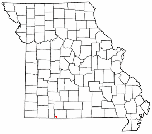
Pottersville is an unincorporated hamlet in Howell County, Missouri, United States. It is located approximately ten miles west of West Plains. Besides a few homes, only a post office and fire station are located there. The ZIP Code for Pottersville is 65790.
Ridgedale is an unincorporated community in southern Taney County, Missouri, United States. It lies approximately ten miles south of Branson on U.S. Route 65, about one-half mile north of the Arkansas state line. The community is part of the Branson, Missouri Micropolitan Statistical Area.

El Paso is an unincorporated community and census-designated place (CDP) in southwestern White County, Arkansas, United States. It was first listed as a CDP in the 2020 census with a population of 267. Its name is Spanish for "the pass", referring to a small gap in the hills on the community's northern edge. Once known as Peach Orchard Gap in its early settlement, the origin of El Paso's Spanish name is unknown.
Pleasant Valley is a neighborhood that is among the older western neighborhoods of the city of Little Rock, Arkansas. The area is to the northwest of Breckenridge and west of Colony West. Pleasant Valley lies to the south of the hillier Pleasant Ridge and Walton Heights areas, and mostly to the east of St. Charles.
Bucyrus is an unincorporated community in central Texas County, Missouri, United States. It is located on Route 17, approximately three miles northwest of Houston. The ZIP Code for Bucyrus is 65444.
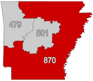
Area codes 870 and 327 are telephone area codes in the North American Numbering Plan (NANP) for southern, eastern, and most of northern Arkansas. 870 was created on April 14, 1997 in a split from area code 501, Arkansas's original area code of 1947 and 327 was added as part of an overlay complex in 2024.
Serena is an unincorporated community and census-designated place in LaSalle County, Illinois, United States. Serena has a post office with ZIP code 60549. Serena was the residence of Peg McDonnell Breslin, the first woman elected to the Illinois Appellate Court outside Cook County.
Timbo is an unincorporated community in Stone County, Arkansas, United States. It is in the Ozark Mountains region of the northern part of the state and is near the town of Mountain View.
West Berlin is an unincorporated community and census-designated place (CDP) located within Berlin Township in Camden County, in the U.S. state of New Jersey. The area is served as United States Postal Service ZIP Code 08091.
Doddridge is an unincorporated community in southern Miller County, Arkansas, United States, approximately five miles north of the Louisiana border. Doddridge is located at the junction of Arkansas Highway 160 and U.S. Route 71, and I-49 passes through the area, connecting it to Texarkana and Louisiana, as well as the confluence of the Sulphur and Red rivers. Although unincorporated, Doddridge has a post office, with the ZIP code of 71834.
Crocketts Bluff is an unincorporated community in Arkansas County, Arkansas, United States. It is the location of Crocketts Bluff Hunting Lodge, which is located at the end of the dirt road north of the point at which AR 153 turns south, and is listed on the National Register of Historic Places. Crocketts Bluff sits at an elevation of 171 feet the highest point in Arkansas County. The ZIP Code for Crocketts Bluff is 72038.
Tichnor is an unincorporated community in Arkansas County, Arkansas, United States. It is the location of the Tichnor Rice Dryer and Storage Building, and is the nearest community to the Roland Site, both listed on the National Register of Historic Places. The ZIP Code for Tichnor is 72166.
Tannenbaum is an unincorporated community in Cleburne County, Arkansas, United States. It shares a ZIP code 72530 with Drasco. Tannenbaum features chalet-like homes built on the northeast side of Greers Ferry Lake near Heber Springs. The community also has a boat dock and ramp, as well as recreational areas and an airfield.
Drasco is an unincorporated community and census-designated place (CDP) in Cleburne County, Arkansas, United States, with a ZIP code of 72530. Drasco lies just northeast of Greers Ferry Lake and includes the lakeside community of Tannenbaum.
Onia is an unincorporated community in Stone County, Arkansas, United States. It has an estimated population of approximately 30 civilians. The ZIP Code for Onia is 72663.
Gregory is an unincorporated community and census-designated place (CDP) in Woodruff County, Arkansas, United States. It was first listed as a CDP in the 2020 census with a population of 43. Gregory is located along Arkansas Highway 33, 9 miles (14 km) south of Augusta. Gregory has a post office with ZIP code 72059.
West Aurora is an unincorporated community in Miller County, in the U.S. state of Missouri.
References
- ↑ U.S. Geological Survey Geographic Names Information System: Jersey, Arkansas
- ↑ "Jersey ZIP Code". zipdatamaps.com. 2022. Retrieved November 11, 2022.
Municipalities and communities of Bradley County, Arkansas, United States | ||
|---|---|---|
| Cities | 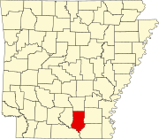 | |
| Town | ||
| Unincorporated communities | ||
33°25′42″N92°18′52″W / 33.42833°N 92.31444°W
| | This article about a location in Bradley County, Arkansas is a stub. You can help Wikipedia by expanding it. |