Related Research Articles

Union County is a county located on the central southern border of the U.S. state of Arkansas. As of the 2020 census, the population was 39,054. The county seat is El Dorado. The county was formed on November 2, 1829, and named in recognition of the citizens' petition for a new county, which said that they were petitioning "in the spirit of Union and Unity." The county is directly adjacent to the south to Union Parish in the state of Louisiana.
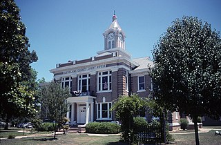
Cleveland County is a county located in the U.S. state of Arkansas. Its population was 7,550 at the 2020 U.S. census. The county seat and largest city is Rison.

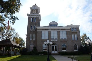
Cleburne County is a county located in the U.S. state of Arkansas. As of the 2020 census, the population was 24,711. The county seat and most populous city is Heber Springs. The county was formed on February 20, 1883, as the last of Arkansas's 75 counties to be formed. It is named for Confederate Major-General Patrick Cleburne. Cleburne is an alcohol prohibition or dry county.
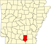
Calhoun County is a county located in the south central part of the U.S. state of Arkansas. As of the 2020 census, the population was 4,739, making it the least populous county in Arkansas. The county seat is Hampton. Calhoun County is Arkansas's 55th county, formed on December 6, 1850, and named for John C. Calhoun, a Vice President of the United States.

Bradley County is a county located in the U.S. state of Arkansas. As of the 2020 census, the population was 10,545. The county seat is Warren. It is Arkansas's 43rd county, formed on December 18, 1840, and named for Captain Hugh Bradley, who fought in the War of 1812.

Jacksonville is a city in Pulaski County, Arkansas, United States, and a suburb of Little Rock. As of the 2010 census, the population of the city was 28,364. It is part of the Little Rock–North Little Rock–Conway Metropolitan Statistical Area with 729,135 people as of 2014.

The Little Missouri River, or Little Mo, is a 147-mile-long (237 km) waterway that runs from the Ouachita Mountains of southwest Arkansas into the rolling hills area in the surrounding countryside.
The South Arkansas Arboretum is an arboretum and botanical garden owned by the local school system but operated as Arkansas's 50th state park by the South Arkansas Community College. It is located next to the former El Dorado High School in El Dorado, Arkansas, USA and open daily except for holidays.
Southern Arkansas University Tech is a public community college in Calhoun County, Arkansas.

South Arkansas lies within the southernmost portions of Arkansas Gulf Coastal Plain and Delta regions. It encompasses the lower 15 counties of the state.

Estero Bay is a bay located on the Pacific Coast in San Luis Obispo County, central California. It is about 15 miles (24 km) from its south end at Point Buchon/Montana de Oro State Park, to its north end at Point Estero, which is about 5 miles (8 km) northwest of Cayucos. It is indented about 5 miles (8 km) into the California coast.
There are several lakes named Mud Lake within the U.S. state of Arkansas.

The Arkansas Timberlands is a region of the U.S. state of Arkansas generally encompassing the area south of the Ouachita Mountains, south of Central Arkansas and west of the Arkansas Delta. With several different definitions in use by various state agencies, the Arkansas Timberlands is essentially a region known for dense pine and cypress forests covering hilly terrain and lining numerous rivers. Modern settlement created a significant logging industry and subsequent clearance agriculture which provided the basis of the local economy until the discovery of petroleum. Local tourism is largely based on the popularity of deer hunting and bass fishing. Attractions there include Marks' Mills Battleground Historical Monument, Jenkins' Ferry Battleground Historical Monument, Overflow National Wildlife Refuge, Felsenthal National Wildlife Refuge, South Arkansas Arboretum, Arkansas Museum of Natural Resources, White Oak Lake State Park, Poison Springs Battleground State Park, Millwood State Park, and Pond Creek National Wildlife Refuge. The Arkansas Timberlands is the birthplace of former President of the United States Bill Clinton.
Clay Bank is an unincorporated community in Gloucester County, in the U. S. state of Virginia.
L’Aigle Creek is a waterway in Bradley County, Arkansas. It is 44.2 miles long. It flows into the Saline River. The Saline River flows into the Ouachita River.
The Moro Bay ferry is a historic ferry site at Moro Bay State Park in southwestern Bradley County, Arkansas. A ferry operated across the Ouachita River at this site from 1828 until 1948, and then again from 1965 to 1992, providing a major crossing point of the river in the immediate region. The towboat and barge used by the 1965-1992 ferry service are now set up as a display in the state park, with historically appropriate signage to its ferry slip. Because the area is prone to flooding, the boats are installed in a way that they will float when flooded. The boats were built in 1948 by the Barbour Metal Boat Works of St. Louis, and were probably the last ferry boats built for public service in the state.