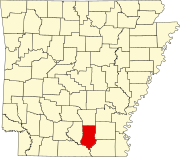
Bradley County is a county located in the U.S. state of Arkansas. As of the 2020 census, the population was 10,545. The county seat is Warren. It is Arkansas's 43rd county, formed on December 18, 1840, and named for Captain Hugh Bradley, who fought in the War of 1812.

Ashley County is a rural South Arkansas county with a culture, economy, and history based on timber and agriculture. Created as Arkansas's 52nd county on November 30, 1848, Ashley County has seven incorporated municipalities, including Hamburg, the county seat and Crossett, the most populous city. The county is also the site of numerous unincorporated communities and ghost towns. The county is named for Chester Ashley, a prominent lawyer in the Arkansas Territory and U.S. senator from the state from 1844 to 1848.
Warren is a city in and the county seat of Bradley County, Arkansas, United States. As of the 2010 census, the population was 6,003.

Ashdown is a city in Little River County, Arkansas, United States. The community was incorporated in 1892 and has been the county seat since 1906. Located within the Arkansas Timberlands between the Little River and the Red River, Ashdown's economy and development have historically been tied to the timber industry. Timber is still a major industry here.

Russellville is the county seat and largest city in Pope County, Arkansas, United States, with a 2021 estimated population of 29,338. It is home to Arkansas Tech University. Arkansas Nuclear One, Arkansas' only nuclear power plant is nearby. Russellville borders Lake Dardanelle and the Arkansas River.

Mount Jackson is a town in Shenandoah County, Virginia, United States. The population was 1,994 at the 2010 census.

Mount Olive is a town in Duplin and Wayne counties in the U.S. state of North Carolina. The population was 4,589 at the 2010 census. It is included in the Goldsboro, North Carolina Metropolitan Statistical Area. The town is home to the Mt. Olive Pickle Company and the University of Mount Olive.

The National Register of Historic Places in the United States is a register including buildings, sites, structures, districts, and objects. The Register automatically includes all National Historic Landmarks as well as all historic areas administered by the U.S. National Park Service. Since its introduction in 1966, more than 90,000 separate listings have been added to the register.

The Warren and Saline River Railroad is an 8-mile (13 km) short-line railroad connecting Cloquet, Arkansas to the Arkansas Midland Railroad at Warren. It has always been independent of larger carriers, and was previously owned by the Potlatch Corporation, a lumber company, until January 2010. WSR is currently operated by the Arkansas Midland Railroad and was sold by Pinsly Railroad Company to sold to Genesee & Wyoming Industries in 2014.

The Mount Hood Railroad is a heritage and shortline freight railroad located in Hood River, Oregon, 60 miles (97 km) east of Portland, Oregon, United States.
Vick is an unincorporated community in Bradley County, Arkansas, United States, near Hermitage. It is situated at 148 feet above mean sea level.

Batesville is an unincorporated community in Albemarle County, Virginia, United States. Its elevation is 620 feet (190 m).

U.S. Route 64 is a U.S. highway running from Teec Nos Pos, Arizona east to Nags Head, North Carolina. In the U.S. state of Arkansas, the route runs 246.35 miles (396.46 km) from the Oklahoma border in Fort Smith east to the Tennessee border in Memphis. The route passes through several cities and towns, including Fort Smith, Clarksville, Russellville, Conway, Searcy, and West Memphis. US 64 runs parallel to Interstate 40 until Conway, when I-40 takes a more southerly route.
Mount Auburn Cemetery is a historic African American cemetery and national historic district in Baltimore, Maryland, United States. Overlooking the Middle Branch of the Patapsco River to the east, Baltimore's Downtown to the north and railroad tracks to the south, Mt. Auburn Cemetery is surrounded by the Cherry Hill, Westport, Mt. Winans and Lakeland communities.

This is a list of the National Register of Historic Places listings in Saline County, Arkansas.

Twelve special routes of U.S. Route 63 currently exist. Arkansas and Missouri each contain five, with two in Iowa. There are also five former routings that have been removed from the system.

Mount Zion Cemetery/Female Union Band Society Cemetery is a historic cemetery located at 27th Street NW and Mill Road NW in the Georgetown neighborhood of Washington, D.C., in the United States. The cemetery is actually two adjoining burial grounds: the Mount Zion Cemetery and Female Union Band Society Cemetery. Together these cemeteries occupy approximately three and a half acres of land. The property fronts Mill Road NW and overlooks Rock Creek Park to the rear. Mount Zion Cemetery, positioned to the East, is approximately 67,300 square feet in area; the Female Union Band Cemetery, situated to the West, contains approximately 66,500 square feet. Mount Zion Cemetery, founded in 1808 as The Old Methodist Burial Ground, was leased property later sold to Mount Zion United Methodist Church. Although the cemetery buried both White and Black persons since its inception, it served an almost exclusively African American population after 1849. In 1842, the Female Union Band Society purchased the western lot to establish a secular burying ground for African Americans. Both cemeteries were abandoned by 1950.

The Mt. Olive Rosenwald School, on Bradley Rd. 45 in Mt. Olive, Bradley County, Arkansas is a wood frame Colonial Revival schoolhouse built in 1927. It is one of five buildings in the county that was funded by The Rosenwald Fund, established by philanthropist Julius Rosenwald to further the education of rural African Americans. It is not known when the building ceased to be used as a school, but classes were offered as late as 1949.
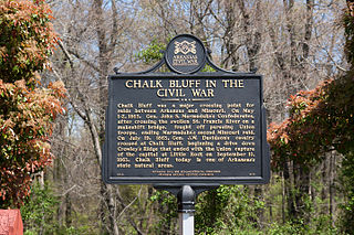
Chalk Bluff was an unincorporated community in Clay County, Arkansas, United States, approximately two miles (3 km) northwest of St. Francis. The town was formed in the 1820s at the point where the St. Francis River cuts through Crowley's Ridge from west to east. The name of the community was derived from the white clay bluff created by this crossing. The founder of the community was Abraham Seitz, who established and operated a ferry crossing and general store in the area from the 1830 until it was destroyed during the Civil War. The community occupied a strategic location and was often referred to in the reports of Union and Confederate forces vying for control of Northeast Arkansas during the war. Several skirmishes occurred near the ferry crossing, one of which was significant it enough to become known as the Battle of Chalk Bluff, which took place in early May 1863. The town was abandoned following the Civil War and most residents moved to the new railroad town, St. Francis, Arkansas. The location was listed on the National Register of Historic Places in 1974.
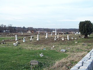
The Mount Olive-Bedford Chapel Cemetery is a historic cemetery in rural White County, Arkansas, northeast of Mount Vernon on Manning Road. It was founded in the 1880s, and is the only surviving remnant of an African-American community called "The Colony". It occupies 1.9 acres (0.77 ha) of basically level ground, and has 86 known burials. Of those, 58 are marked in some way, by some combination of head and foot stones. There are likely more burials on the property. The property includes the Mount Olive Baptist Church, a small clapboarded wood-frame building which has elements dating to the community's founding. The cemetery was listed on the National Register of Historic Places in 2019.