
Talpiot is an Israeli neighborhood in southeastern Jerusalem, established in 1922 by Zionist pioneers. It was built as a garden suburb on land purchased by the Tel Aviv-based Palestine Land Development Company and other Jewish building societies.

Nof HaGalil is a city in the Northern District of Israel with a population of 44,184.

Pisgat Ze'ev is an Israeli settlement in East Jerusalem and the largest residential neighborhood in Jerusalem with a population of over 50,000. Pisgat Ze'ev was established by Israel as one of the city's five Ring Neighborhoods on land effectively annexed after the 1967 Six-Day War.

Ein Karem is a historic mountain village southwest of Jerusalem, presently a neighborhood in the outskirts of the modern city, within the Jerusalem District. It is the site of the Hadassah Medical Center.

Har Nof is a neighborhood on a hillside on the western boundary of Jerusalem with a population of 20,000 residents, predominantly Orthodox Jews.

Givat Shaul is a neighborhood in West Jerusalem. The neighborhood is located at the western entrance to the city, east of the neighborhood of Har Nof and north of Kiryat Moshe. Givat Shaul stands 820 meters above sea level.

Beit HaKerem is a largely secular upscale neighborhood in southwest Jerusalem. It is located between Kiryat Moshe to the northwest and Bayit VeGan to the south. Beit HaKerem has a population of 15,000.

Kiryat HaYovel is a neighborhood in southwestern Jerusalem on Mount Herzl. It was built in the early 1950s to house Jewish refugees who fled the Arab world. Today, Kiryat HaYovel has a population of 25,000 residents.
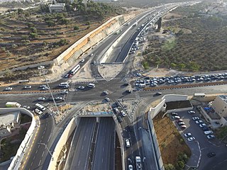
Highway 50, officially called Begin Boulevard and also referred to as Menachem Begin Expressway or Begin Highway, is a north-south urban freeway, through western Jerusalem, named after Israel's sixth Prime Minister, Menachem Begin. Local Jerusalemites simply refer to it as 'Begin'. It enters Area C of the West Bank on the north end and East Jerusalem on both ends.

Yad Kennedy, located in the Mateh Yehuda Region near Jerusalem, is a memorial to John F. Kennedy, the 35th President of the United States, who was assassinated in Dallas, Texas in 1963. The 60-foot high (18 m) memorial is shaped like the stump of a felled tree, symbolizing a life cut short. Inside is a bronze relief of Kennedy, with an eternal flame burning in the center. It is encircled by 51 concrete columns, one for each of the 50 states in the United States plus one for Washington, D.C., the United States capital. The emblems of the states are displayed on each of the columns, and the columns are separated by slim panels of glass. The monument measures approximately 250 feet (76 m) in circumference around its base, and there is space within the memorial for approximately 100 visitors at a time. The monument was built in 1966 with funds donated by American Jewish communities.
Mateh Yehuda Regional Council is a regional council in the Jerusalem District of Israel. In 2024 it was home to 51,125 people.

Beit Safafa is a Palestinian town along the Green Line, with the vast majority of its territory in East Jerusalem and some northern parts in West Jerusalem.
Yefeh Nof is a neighborhood in west Jerusalem, founded in 1929. Together with Ramat Beit HaKerem and Givat Beit HaKerem, it is part of the larger Beit HaKerem neighborhood. Its name is one of the seventy poetic names the Hebrew Bible uses for Jerusalem, and literally means "beautiful view".

Ramat Beit HaKerem is a Jewish neighborhood in Jerusalem. It was established in 1991 on a hill between Beit HaKerem to the north, the Givat Ram campus of the Hebrew University to the east, and Bayit VeGan to the southwest.
Givat Beit HaKerem is a Jewish neighborhood in Jerusalem. It is located in the west part of Jerusalem.

Route 386 is a road in Israel that runs from Tzur Hadassah to Jerusalem.
Kanfei Nesharim Street is a major east–west thoroughfare in the Givat Shaul neighborhood of western Jerusalem. Unlike most Jerusalem streets, Kanfei Nesharim is a wide thoroughfare with two traffic lanes in each direction, separated by a median, and spans 3 kilometres (1.9 mi) in a straight line. It connects the neighborhood of Kiryat Moshe on the east to Har Nof on the west, and includes the modern commercial strip of office buildings, stores and restaurants in what is termed Givat Shaul Bet.

Nof Zion is a Jewish religious neighborhood and an Israeli settlement inside of the Palestinian Arab neighborhood of Jabel Mukaber, East Jerusalem.

The Garden of the Righteous Among the Nations is part of the much larger Yad Vashem complex located on the Mount of Remembrance in Jerusalem. Along with some two dozen different structures within the Yad Vashem memorial – which is the second most-visited destination in the country after the Western Wall – the Garden of the Righteous is meant to honor those non-Jews who during the Holocaust risked their lives to save Jews from extermination by the Nazis.

Zikhron Tuvya, also spelled Zichron Tuvia, is a former courtyard neighborhood in Jerusalem. Founded in 1890, it was the twenty-third Jewish neighborhood to be established outside the Old City walls. The neighborhood consisted of parallel row-houses facing each other across a wide street, today named Zikhron Tuvya Street. Initially populated by tradesmen and workshops, it became a residential neighborhood after the 1920s. It is now part of the larger Nachlaot neighborhood.

