
The Andaman and Nicobar Islands, a union territory of India, are a group of 572 islands of which 38 are inhabited at the juncture of the Bay of Bengal and the Andaman Sea.

Odisha, formerly Orissa, is an Indian state located in Eastern India. It is the 8th largest state by area, and the 11th largest by population. The state has the third largest population of Scheduled Tribes in India. It neighbours the states of West Bengal and Jharkhand to the north, Chhattisgarh to the west, and Andhra Pradesh to the south. Odisha has a coastline of 485 kilometres (301 mi) along the Bay of Bengal. The region is also known as Utkala and is mentioned in India's national anthem, "Jana Gana Mana". The language of Odisha is Odia, which is one of the Classical Languages of India.

Mirzapurpronunciation (help·info) is a city in Uttar Pradesh, India, roughly 650 km from both Delhi and Kolkata, almost 84 km from Allahabad and 59 km from Varanasi. It is known for its carpets and brassware industries. The city is surrounded by several hills and is the headquarters of Mirzapur district. It is famous for the holy shrine of Vindhyachal, Ashtbhuja and Kali khoh and also Devrahwa Baba ashram. It has many waterfalls and natural spots.

An urban area, or built-up area, is a human settlement with a high population density and infrastructure of built environment. Urban areas are created through urbanization and are categorized by urban morphology as cities, towns, conurbations or suburbs. In urbanism, the term contrasts to rural areas such as villages and hamlets; in urban sociology or urban anthropology it contrasts with natural environment. The creation of early predecessors of urban areas during the urban revolution led to the creation of human civilization with modern urban planning, which along with other human activities such as exploitation of natural resources led to a human impact on the environment. "Agglomeration effects" are in the list of the main consequences of increased rates of firm creation since. This is due to conditions created by a greater level of industrial activity in a given region. However, a favorable environment for human capital development would also be generated simultaneously.

West Champaran is an administrative district in the state of Bihar in India, located just 60 km (37 mi) west of Birgunj. It is a part of Tirhut Division. The district headquarters are located in Bettiah. The district is known for its fluid border with Nepal. One of the major location in West Champaran is Kumar Bagh for SAIL Special Processing Unit and Bhitiharwa where Mahatma Gandhi started Satyagrah Aandolan.

Lakshadweep is a group of islands in the Lakshadweep Sea, 200 to 440 km off the southwestern coast of India. The archipelago is administered as a union territory and district of India. They were also known as the Laccadive Islands, although geographically this is only the name of the central subgroup of the group. Lakshadweep means "one hundred thousand islands" in Sanskrit, Marathi and Malayalam. The islands form the smallest Union Territory of India and their total surface area is just 32 km2 (12 sq mi). The lagoon area covers about 4,200 km2 (1,600 sq mi), the territorial waters area 20,000 km2 (7,700 sq mi) and the exclusive economic zone area 400,000 km2 (150,000 sq mi). The region forms a single Indian district with 10 subdivisions. Kavaratti serves as the capital of the Union Territory and the region comes under the jurisdiction of Kerala High Court. The islands are the northernmost of the Lakshadweep–Maldives–Chagos group of islands, which are the tops of a vast undersea mountain range, the Chagos-Lakshadweep Ridge.

Chennai district, formerly known as Madras district, is one of the 38 districts in the state of Tamil Nadu in India. It is the smallest and densest of all the districts in the state. The district is coterminous with the Greater Chennai City. As of 2011, the district had a population of 7,100,000 with a sex-ratio of 989 females for every 1,000 males.

The National Capital Region (NCR) is a central planning region centred upon the National Capital Territory (NCT) of Delhi in India. It encompasses Delhi and several districts surrounding it from the states of Haryana, Uttar Pradesh and Rajasthan. The NCR and the associated National Capital Region Planning Board were created in 1985 to plan the development of the region and to evolve harmonized policies for the control of land-uses and development of infrastructure in the region. Prominent cities of NCR include Faridabad, Ghaziabad, Gurgaon, New Delhi and Noida.

Darbhanga district is one of the thirty-eight districts of Bihar state in eastern India, and Darbhanga city is the administrative headquarters of this district and 5th largest city of Bihar as well. Darbhanga district is a part of Darbhanga Division. The district is bounded on the north by Madhubani district, on the south by Samastipur district, on the east by Saharsa district and on the west by Sitamarhi and Muzaffarpur districts. The district covers an area of 2,279 km2 (880 sq mi).

Ghazipur district (Ghāzīpur) is a district of Uttar Pradesh state in northern India. The city of Ghazipur is the district headquarters. The district is part of Varanasi Division. The region of Ghazipur is famous mainly for the production of its unique rose scented Spray called Gulab Jal, and for the tomb of the Governor General of British India, Lord Cornwallis, who died here. His tomb is situated in Western part of City, and is conserved by Archaeological Survey of India.
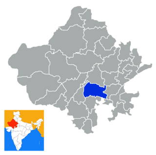
Bhilwara District is a district of the state of Rajasthan in western India. The town of Bhilwara is the district headquarters.
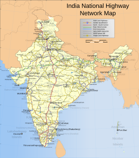
Roads are an important mode of transport in India. India has a network of over 5,897,671 kilometres (3,664,643 mi) of roads as of 31 March 2017. This is the second-largest road network in the world, after the United States with 6,645,709 kilometres (4,129,452 mi). At 1.80 kilometres (1.12 mi) of roads per square kilometre of land, the quantitative density of India's road network is equal to that of Germany, and substantially higher than the United States, China, Brazil and Russia. Adjusted for its large population, India has approximately 4.87 kilometres (3.03 mi) of roads per 1,000 people, which is much lower compared to developed countries. As of 31 March, 2017, 63.24% of Indian roads were paved. India's road network carries over 65 percent of its freight and about 85 percent of passenger traffic. It contributed 4.7% towards India's gross domestic product. This is in comparison to railways, which contributed 1% from 2009 to 2010.
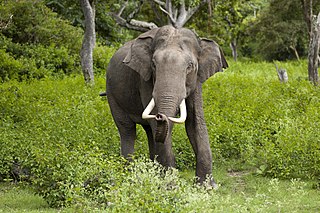
The Indian elephant is one of three extant recognised subspecies of the Asian elephant and native to mainland Asia.

Bhiwadi is a city in Alwar district of Rajasthan state in India. It is an industrial hub in Rajasthan.

Banga is a town and Municipal council in the Shahid Bhagat Singh Nagar district of Punjab, India. Banga is also one of the sub-division (tehsil) headquarters of the district. Banga located on Phagwara-Rupnagar section of National Highway 344A. It is currently estimated to have a population of about 23,000 and is classified as a class 2 Municipality. The town also incorporates the former village of Jindowal apart from Banga town.
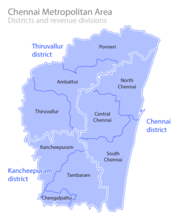
The Chennai Metropolitan Area (CMA) (or) Greater Chennai is the fourth-most populous metropolitan area in India, the 22nd-most in Asia, and the 40th-most in the world. The CMA consists of the central city of Chennai and its suburbs distributed in Kanchipuram, Chengpattu, Thiruvallur districts and Arakkonam in Ranipet district. The Chennai Metropolitan Development Authority (CMDA) is the nodal agency that handles town planning and development within the metro area. Since 1974, an area encompassing 1189 km2 around the city has been designated as the CMA and the CMDA has been designated as the authority to plan the growth of the city and the area around it.

Honnihalli is a village in Belagavi district in the southern state of Karnataka, India.