Related Research Articles

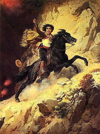
Joaquin Murrieta Carrillo, also called the Robin Hood of the West or the Robin Hood of El Dorado, was a Mexican-American figure of disputed historicity. The novel The Life and Adventures of Joaquín Murieta: The Celebrated California Bandit (1854) by John Rollin Ridge ostensibly recounts his story.

Henry W. Coe State Park is a state park of California, United States, preserving a vast tract of the Diablo Range. The park is located closest to the city of Morgan Hill, and is located in both Santa Clara and Stanislaus counties. The park contains over 87,000 acres (35,000 ha), making it the largest state park in northern California, and the second-largest in the state. Managed within its boundaries is a designated wilderness area of about 22,000 acres (8,900 ha). This is officially known as the Henry W. Coe State Wilderness, but locally as the Orestimba Wilderness. The 89,164-acre (36,083 ha) park was established in 1959.
The Five Joaquins (1850–1853) were an outlaw gang which the State of California said was led by:
Poso de Chane or Poso Chane is a former settlement in Fresno County, California situated around the waterhole of that name, northwest just below the confluence of the Jacalitos Creek with Los Gatos Creek, 6 miles (9.7 km) east of Coalinga and northwest of the Guijarral Hills.
Cantua Creek, formerly in Spanish Arroyo de Cantúa, was named for José de Guadalupe Cantúa, a prominent Californio Ranchero in the 19th-century Mexican era of Alta California.
Bitterwater Creek, originally named Arroyo de Matarano, is a stream in eastern San Luis Obispo County and northwestern Kern County, central California.
La Vereda del Monte was a backcountry route through remote regions of the Diablo Range, one of the California Coast Ranges. La Vereda del Monte was the upper part of La Vereda Caballo,, used by mesteñeros from the early 1840s to drive Alta California horses to Sonora for sale.
Blackbird Valley, earlier known as "Valle de Mocho", is a valley south of Mount Mocho in the Diablo Range in Santa Clara County, California. It lies at an elevation of 2,552 foot / 778 meters.
Isabel Valley is a valley in the Diablo Range in Santa Clara County, California. It is also known as Santa Ysabel Valley.
French Ranch is a locale northeast of Hollister in the Diablo Range, in San Benito County, California. It lies on a flat just south of Wildcat Canyon at an elevation of 1,821 feet at the foot of Frenchs Pass. It lies west of an unnamed stream that descends northward to its confluence with Wildcat Canyon Creek from the north slope of Antimony Peak.
Mustang Flat is a flat in the Diablo Range in Stanislaus County, California. It lies at an elevation of 1,329 feet south of the South Fork Orestimba Creek, north of Mustang Peak.
Fifield Ranch is a locale within the Diablo Range in Santa Clara County, California. It lies at an elevation of 1,512 feet, west of the head of Romero Creek and the Santa Clara County line, about a mile north of Hagerman Peak. It is at the source of a tributary canyon and stream to Chimney Gulch, itself a tributary of East Fork Pacheco Creek.
Joaquin Valenzuela was a Sonoran fortyniner who came to California in 1849, during the California Gold Rush, with a small band of people from the vicinity of their hometown with Joaquin Murrieta. He subsequently became one of the leaders of the Five Joaquins Gang. Descendants of his family and those of former gang members said he died in 1853, at the hands of the California Rangers on Cantua Creek. The San Luis Obispo Vigilantes claim he was still alive when they took him to be hanged for his crimes with the Five Joaquins Gang in San Luis Obispo in 1858.
Jesus Valenzuela, also known as Joaquin Ocomorenia, the alias used by him as a member of the Five Joaquins Gang, born in Pueblo de Murrieta, he was the brother of Joaquin and Teodoro Valezuela and a cousin of Joaquin Murrieta and his brothers and other Murrieta cousins. He came to California in 1849 with his brothers, Joaquin Murrieta and his brothers and cousins.
County Line Road is an unimproved road between the San Antonio Valley and Fifield Ranch that closely follows the east-west divide of the Diablo Range and the County boundary of Santa Clara County, and Stanislaus County, California. This road followed the route called La Vereda del Monte, used by Californio mesteñeros and the gang of Joaquin Murrieta and other bandits and horse-thieves, and sites of three of their camps along the route are found along it. Two sites are now state park campgrounds, the last is at ranch dating back to the 1860s.
Bullhead Canyon, is a canyon and tributary stream of the North Fork Pacheco Creek in Santa Clara County, California. Its mouth is on its confluence with North Fork Pacheco Creek at an elevation of 630 feet. Its source and its upper reach is at 37°10′08″N121°19′04″W within the boundary of Henry W. Coe State Park. It is overlooked to the north by the County Line Road,, that runs west to east along the divide of the Diablo Range and the boundary of Santa Clara and Stanislaus County, California.
Joaquin Ridge is a ridge in the Diablo Range in Fresno County, California. The ridge is named for Joaquin Murietta (1830-1853), a California Gold Rush bandit, leader of the Five Joaquins Gang, who used this region as a rendezvous and camp that overlooked the gangs base at the Rancho de Cantua. The ridge is ten miles long, running from its high point at 36°19′48″N120°34′09″W, east of Spanish Lake, eastward to Joaquin Rocks 36°19′11″N120°27′32″W, and then southwestward to 36°18′15″N120°24′11″W near 3,629-foot Black Mountain at 36°18′16″N120°24′12″W the high point on the south southeast trending Anticline Ridge. Joaquin Ridge is bound on the northeast by the Ragged Valley and the Big Blue Hills and on the southwest by Portuguese Canyon. Its highest elevation is 4,701 feet, 0.64 km (0.40 mi) east of Spanish Lake.
Murrieta Spring is a historic spring flowing from the south bank of Cantua Creek, about 100 yards above where El Camino Viejo crossed the Creek in the San Joaquin Valley. The Spring formed a pool in the arroyo where it emerged from the foot of the eastern mountains of the Diablo Range, a mile above where formerly California State Route 33, now South Derrick Avenue, crosses Cantua Creek. This is where Harry Love and his detachment of California Rangers found the gang of Joaquin Murrieta at the spring and attacked them on July 25, 1853.
Pedro Gonzales, origins unknown, possibly a Sonoran, was killed in July 1852 by Harry Love at what is now the Conejo Grade. He was a known member of the Five Joaquins Gang riding with Joaquin Murrieta's band, as published in newspapers of the time. Another Pedro Gonzales, also a member of the Gang, a Californio that rode with Joaquin Valenzuela, and was killed on July 25, 1853 at the battle of the Arroyo Cantua, was uncovered decades later by the research of Frank F. Latta.

Joaquin Rocks are a group of three pillars of rock, originally known as "Las Tres Piedras", located on Joaquin Ridge, in the Diablo Range, in Fresno County, California. The Joaquin Rocks are at an elevation of 4,121 feet, and are the most distinguishing feature of Joaquin Ridge. The three pillars of rock are clearly visible on the ridge for many miles from many directions in the San Joaquin Valley and from their summits have a view of much of the valley. It is located, 3 miles (4.8 km) west-northwest of Black Mountain and 3 miles (4.8 km) southwest of Ragged Valley.
References
- ↑ U.S. Geological Survey Geographic Names Information System: Joaquin Spring
- 1 2 Frank F. Latta, JOAQUIN MURRIETA AND HIS HORSE GANGS, Bear State Books, Santa Cruz, California. 1980.
Coordinates: 36°18′55″N120°27′11″W / 36.31528°N 120.45306°W