The Bay of Whales was a natural ice harbour, or iceport, indenting the front of the Ross Ice Shelf just north of Roosevelt Island, Antarctica, at the southernmost point of the world's ocean. While the Ross Sea stretches considerably further south – encompassing the Gould Coast, located around 320 kilometres from the South Pole – the majority of this expanse is covered by the Ross Ice Shelf, rather than open sea.
Arthur Harbour is a small harbour entered between Bonaparte Point and Amsler Island on the south-west coast of Anvers Island in the Palmer Archipelago of Antarctica.
The Trojan Range is a mountain range rising to 2,760 metres (9,055 ft), extending northward from Mount Francais along the east side of Iliad Glacier, Anvers Island, in the Palmer Archipelago of the British Antarctic Territory. It was surveyed by the Falkland Islands Dependencies Survey (FIDS) in 1955 and named by the UK Antarctic Place-Names Committee (UK-APC) for the Trojans, one of the opposing sides in the Trojan War in Homer's Iliad.

Larsen Harbour is a narrow 2.6 miles (4.2 km) long inlet of indenting volcanic rocks and sheeted dykes known as the Larsen Harbour Formation. It is a branch of Drygalski Fjord, entered 2.5 miles (4 km) west-northwest of Nattriss Head, at the southeast end of South Georgia Island. It was charted by the Second German Antarctic Expedition, 1911–12, under Filchner, who named it for Captain Carl Anton Larsen a Norwegian explorer, who made significant contributions to the exploration of Antarctica. The most significant of these was the first discovery of fossils on the continent, for which he received the Back Grant from the Royal Geographical Society. Larsen is also considered the founder of the Antarctic whaling industry and the settlement and whaling station of Grytviken, South Georgia.
Amsler Island is a small island off the south coast of Anvers Island in the Palmer Archipelago of Antarctica. It sits between Loudwater Cove and Arthur Harbour.
The Porthos Range is the second range south in the Prince Charles Mountains of Antarctica, extending for about 30 miles in an east-to-west direction between Scylla Glacier and Charybdis Glacier. First visited in December 1956 by the Australian National Antarctic Research Expeditions (ANARE) southern party under W.G. Bewsher (1956-57) and named after Porthos, a character in Alexandre Dumas, père's novel The Three Musketeers, the most popular book read on the southern journey.

Flask Glacier, is a gently-sloping glacier, 25 nautical miles long, flowing east from Bruce Plateau to enter Scar Inlet between Daggoo Peak and Spouter Peak in Graham Land, Antarctica. The lower reaches of this glacier were surveyed and photographed by the Falklands Islands Dependencies Survey (FIDS) in 1947. The entire glacier was photographed by the Falkland Islands and Dependencies Aerial Survey Expedition in 1955–56, and mapped by the FIDS in 1957. It was named by the UK Antarctic Place-names Committee after the third mate on the Pequod in Herman Melville's Moby-Dick; or, The White Whale.

Posadowsky Glacier is a glacier about 9 nautical miles long, flowing north to Posadowsky Bay immediately east of Gaussberg. Posadowsky Bay is an open embayment, located just east of the West Ice Shelf and fronting on the Davis Sea in Kaiser Wilhelm II Land. Kaiser Wilhelm II Land is the part of East Antarctica lying between Cape Penck, at 87°43'E, and Cape Filchner, at 91°54'E, and is claimed by Australia as part of the Australian Antarctic Territory. Other notable geographic features in this area include Drygalski Island, located 45 mi NNE of Cape Filchner in the Davis Sea, and Mirny Station, a Russian scientific research station.
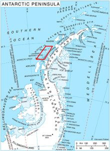
Wylie Bay is a bay 4 nautical miles (7 km) wide, lying between Cape Monaco and Norsel Point on the southwest coast of Anvers Island, in the Palmer Archipelago. First charted by the French Antarctic Expedition under Charcot, 1903–1905, it was named by the United Kingdom Antarctic Place-Names Committee (UK-APC) in 1959 for John P. Wylie, Falkland Islands Dependencies Survey (FIDS) surveyor at Arthur Harbor in 1956 and 1957.
Celsus Peak is a peak 2 nautical miles (4 km) west of D'Ursel Point in the southern part of Brabant Island, in the Palmer Archipelago. It was first mapped by the Belgian Antarctic Expedition, 1897–99, under Gerlache. It was photographed by Hunting Aerosurveys Ltd in 1956–57, mapped from these photos in 1959, and named by the UK Antarctic Place-Names Committee for Aulus Cornelius Celsus, a Roman who lived in the 1st century AD and was a great Latin classical medical writer. The estimated terrain elevation above sea level is 712 metres.
Wardle Entrance is a small southeast entrance to Johannessen Harbour, lying between Snodgrass and Weller Islands, Pitt Islands, in the Biscoe Islands. Photographed by Hunting Aerosurveys Ltd. in 1956 and mapped from these photos by the Falkland Islands Dependencies Survey (FIDS). Named by the United Kingdom Antarctic Place-Names Committee (UK-APC) after one of the central characters in Charles Dickens' Pickwick Papers.
D'Ursel Point is a headland which marks the south side of the entrance to Buls Bay on the southeast coast of Brabant Island, in the Palmer Archipelago.
Flint Glacier is a glacier which flows south into Whirlwind Inlet between Demorest Glacier and Cape Northrop, on the east coast of Graham Land, Antarctica. It was discovered by Sir Hubert Wilkins on his flight of December 20, 1928, and photographed from the air by the United States Antarctic Service in 1940. It was charted in 1947 by the Falkland Islands Dependencies Survey, who named it for glaciologist Richard F. Flint, professor of geology at Yale University.
The Fowler Islands are a group of small islands lying between the Bernal Islands and the Bragg Islands in Crystal Sound, off the coast of Antarctica. They were mapped from air photos obtained by the Ronne Antarctic Research Expedition (1947–48) and the Falkland Islands and Dependencies Aerial Survey Expedition (1956–57), and from surveys by the Falkland Islands Dependencies Survey (1958–59). They were named by the UK Antarctic Place-Names Committee for Sir Ralph H. Fowler (1889–1944), an English physicist, joint author with J.D. Bernal of a classic paper in 1933 on the structure of ice which suggested the location of the hydrogen atoms now known as the ice rules.
Morrell Point' is the northernmost point on the west coast of Thule Island in the South Sandwich Islands. It was named by the UK Antarctic Place-Names Committee in 1971 for Benjamin Morrell, a sealer of Stonington, Connecticut, who visited the island in the Wasp in 1823.

Mikkelsen Harbour is a small bay indenting the south side of Trinity Island between Skottsberg Point and Borge Point, in the Palmer Archipelago, Antarctica. It provides excellent anchorage for ships, and was frequently used by sealing vessels in the first half of the nineteenth century and by Norwegian whaling vessels at the beginning of the twentieth century.
Harbour Glacier is a through glacier 3 nautical miles (6 km) long and 1.5 nautical miles (3 km) wide, lying on the northwest side of Wiencke Island and extending in a northeast direction from Port Lockroy to the cove 1 nautical mile (2 km) east of Noble Peak, in the Palmer Archipelago, Antarctica. It was probably first seen by the Belgian Antarctic Expedition, 1897–99, under Gerlache. The glacier was charted in 1944 by the Falkland Islands Dependencies Survey, who so named it because of its proximity to the harbour of Port Lockroy.
Mount Mangin is a mountain, 2,040 metres (6,700 ft) high, standing 5 nautical miles (9 km) northeast of Mount Barre on Adelaide Island, Antarctica. It was discovered by the French Antarctic Expedition, 1908–10, and named by Jean-Baptiste Charcot for the noted French botanist Louis A. Mangin.

Mapple Glacier is a narrow glacier 15 nautical miles (28 km) long, flowing eastward between Arkovna Ridge and Stevrek Ridge in the Aristotle Mountains of Antarctica to enter Sexaginta Prista Bay on the east side of Graham Land. It lies 2 nautical miles (4 km) north of Melville Glacier and is separated from it by a line of small peaks. The glacier was surveyed by the Falkland Islands Dependencies Survey in 1961, and was named by the UK Antarctic Place-Names Committee after Father Mapple, the whalemen's Nantucket priest in Herman Melville's Moby-Dick.

MV Norsel was a Norwegian sealing ship home ported in Tromsø. Launched during the final weeks of the Second World War as Lyngdalsfjord and only completed in late 1949, the ship sailed in both Arctic and Antarctic waters for more than 53 years until shipwrecking off the coast of Norway in 1992.