
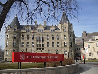
The University of Manitoba is a public research university in Winnipeg, Manitoba, Canada. Founded in 1877, it is the first university of Western Canada. Both by total student enrolment and campus area, the University of Manitoba is the largest university in the province of Manitoba. Its main campus is located in the Fort Garry neighbourhood of Winnipeg, with other campuses throughout the city: the Bannatyne Campus, the James W. Burns Executive Education Centre, the William Norrie Centre, and the French-language affiliate, Université de Saint-Boniface in the Saint Boniface ward.

St. John's College is an Anglican-based independent constituent college of the University of Manitoba, located on the university's Fort Garry campus in Winnipeg, Manitoba.

Charleswood is a residential community and neighbourhood in Winnipeg, Manitoba, Canada. It is located in the South-West of the city and is bordered by the neighbourhoods Tuxedo to the East, Fort Whyte to the South, and the Rural Municipality of Headingley on the West. Its boundaries are Roblin and the Assiniboine River to the north, Shaftesbury Boulevard on the East, Wilkes Avenue to the South and the Perimeter Highway to the West.

Niverville is a town in the Eastman Region, Manitoba, Canada. The town lies between the northwest corner of the Rural Municipality of Hanover and the southeastern portion of the Rural Municipality of Ritchot. Niverville's population as of the 2021 census is 5,947, making it the largest town and 10th-largest community in Manitoba.
East Kildonan is a primarily residential community in northeast Winnipeg, Manitoba, Canada. Commonly known by its initials EK, the suburb has a population of approximately 35,800 as of the 2016 Census.
Wesley College was a college that existed in Winnipeg, Manitoba, Canada, from 1888 to 1938. In 1924, Wesley College became part of the United Church of Canada. It was one of the University of Winnipeg's founding colleges.
Academy Road is a street in Winnipeg, Manitoba, Canada. It runs from the Maryland Bridge to Wellington Crescent, just west of Route 90, and actually intersects with Wellington at both its east and west ends. Academy Road is located in the residential neighbourhood of River Heights and has many retail stores along it.

Fort Rouge is a district of Winnipeg, Manitoba, in Canada. Located in the south-central part of the city, it is bounded on the north by the Assiniboine River, on the east and south by the Red River, and on the west by Stafford Street and Pembina Highway.
North Kildonan is a city ward in northern Winnipeg, and a former municipality in Manitoba, Canada. Its population as of 2016 was 44,664.

Neepawa is a town in Manitoba, Canada, on the Yellowhead Highway at the intersection with Highway 5.

The West End is a mostly residential area of Downtown Winnipeg, Manitoba, Canada. It includes the neighbourhoods of Armstrong's Point, Colony, Daniel McIntyre, Minto, Sargent Park, Spence, St. Matthews, West Broadway, and Wolseley.
Manitoba Centennial Centre is an arts and cultural district that covers a 34-acre area in the east Exchange District of the Point Douglas area in Winnipeg, Manitoba, linking several of Manitoba's important arts and cultural facilities.

Winnipeg's North End is a large urban area located to the north and northwest of Downtown Winnipeg. It is bordered by the Red River on the east, the Canadian Pacific Railway (CPR) mainline on the south, the City of Winnipeg boundary on the west and Jefferson Avenue, Keewatin Street, Carruthers Avenue, McGregor Street and the lane between McAdam and Smithfield Avenues on the north. It is the northern section of the City of Winnipeg as it existed prior to the 1972 municipal amalgamation. Winnipeg's northern suburbs such as West Kildonan and Old Kildonan are not considered part of the North End. The CPR mainline and its Winnipeg yards, which are one of the largest railway yards in the world, act as a physical barrier between the North End and the rest of Winnipeg to the south. This has resulted in the North End remaining a very distinct and unique part of Winnipeg.
Lac du Bonnet is a town in Manitoba, Canada located 115 km (71 mi) northeast of Winnipeg on the west shore of the Winnipeg River. It is surrounded by the Rural Municipality of Lac du Bonnet. The word "Bonnet" is pronounced by locals as "bonny."
Elm Park is a neighbourhood in the city of Winnipeg, Manitoba, Canada. Located in the northern section of the district of St. Vital, it is bounded to the north by the Red River, to the east by St. Mary's Road, to the south by Fermor Avenue, and to the west by Dunkirk Drive. As of the 2021 census, Elm Park had a population of 1,435.

Central Park is a large urban park located in downtown Winnipeg, and forms the heart of the neighbourhood of the same name.
Herbert Henry Gatenby Moody was a Canadian architect. He was born on 12 March 1903 to A. W. Moody and Elizabeth Jane Holland. He was educated at the Royal Military College of Canada in Kingston, Ontario. He graduated from the University of Manitoba with a degree in architecture in 1926.

Isadore "Issie" Coop (1926–2003) was a Canadian architect and a Fellow of the Royal Architectural Institute of Canada, with a reputation for highly functional, cost-effective architecture. A student of the famed American-German architect Ludwig Mies van der Rohe, Coop brought the Miesian style to Winnipeg, and changed the face of Winnipeg architecture, according to one writer.
Ernest John Smith was a Canadian architect.
The Gray Academy of Jewish Education is a pluralistic Jewish day school in Winnipeg, Manitoba, and the only K–12 Jewish day school in western Canada.
