Carabaya Province is a province of the Puno Region in the southern part of Peru. It is bounded on the north by the Madre de Dios Region, on the east by the Sandia Province, on the south by the provinces of Azángaro, Melgar and Putina and on the west by the Cusco Region. The capital of the province is the city of Macusani.
Corani is one of ten districts of the Carabaya Province in Peru.
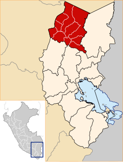
Ollachea District is one of ten districts of the province Carabaya in Peru.
Lake Chaupicocha is a lake in Peru located in the Puno Region, Carabaya Province, Macusani District. It lies in the Carabaya mountain range, south of Allincapac and southwest of Chichicapac.

Macho Ritti is a mountain in the Vilcanota mountain range in the Andes of Peru, about 5,200 metres (17,060 ft) high. It is located in the Puno Region, Carabaya Province, on the border of the districts Corani and Ollachea. Macho Ritti lies north-west of the lakes Mancacocha and Jomercocha and north of the mountain Ananta.
Riti Huasi is a mountain in the Vilcanota mountain range in the Andes of Peru, about 5,000 metres (16,404 ft) high. It is situated in the Puno Region, Carabaya Province, on the border of the districts Corani and Ollachea.
Jatuncucho is a mountain in the Vilcanota mountain range in the Andes of Peru, about 5,400 metres (17,717 ft) high. It is situated in the Cusco Region, Canchis Province, San Pablo District, in the Puno Region, Carabaya Province, Corani District, and in the Melgar Province, Nuñoa District. Jatuncucho lies between Pomanota in the north-west and Jonorana in the east and north-east of the mountain Cochacucho.
Llusca Ritti or Ayachincana is a mountain in the Vilcanota mountain range in the Andes of Peru, approximately 5,200 metres (17,060 ft) high. It is located in the Cusco Region, Quispicanchi Province, Marcapata District, and in the Puno Region, Carabaya Province, Ollachea District. Llusca Ritti lies south of Sullulluni and northwest of Jori Pintay.
Quello Cunca is a mountain in the Vilcanota mountain range in the Andes of Peru, about 5,100 metres (16,732 ft) high. It is situated in the Cusco Region, Quispicanchi Province, Marcapata District. Quello Cunca lies southwest of the mountains Sullulluni, Llusca Ritti and Jori Pintay, southwest of the mountain Tocllayoc and north of the mountain Condor Puñuna.
Taruca Sayana is a mountain in the Vilcanota mountain range in the Andes of Peru, about 5,200 metres (17,060 ft) high. It is located in the Puno Region, Carabaya Province, on the border of the districts Corani and Ollachea. Taruca Sayana lies southeast of the mountains Llusca Ritti (Cusco-Puno) and Jori Pintay, south of the mountain Ananta Cucho and northwest of the mountains Llusca Ritti and Quello Sallayoc.
Quello Sallayoc is a mountain in the Vilcanota mountain range in the Andes of Peru, about 5,000 metres (16,404 ft) high. It is located in the Puno Region, Carabaya Province, on the border of the districts Corani and Ollachea. Quello Sallayoc lies south-east of the mountains Llusca Ritti (Cusco-Puno), Jori Pintay and Taruca Sayana, west of the mountain Riti Huasi and northwest of the mountains Yana Sallayoc and Llusca Ritti. Its ridge stretches to the northeast.
Yurac Salla is a mountain in the Vilcanota mountain range in the Andes of Peru, about 5,000 metres (16,404 ft) high. It is lies in the Puno Region, Carabaya Province, Ollachea District. Yurac Salla is situated north-east of the mountains Jori Pintay, Taruca Sayana and Quello Sallayoc.
Tocllayoc is a 5,291-metre-high (17,359 ft) mountain in the Vilcanota mountain range in the Andes of Peru. It is located in the Cusco Region, Quispicanchi Province, Marcapata District, and in the Puno Region, Carabaya Province, Corani District. Tocllayoc lies southeast of Llusca Ritti, southwest of Jori Pintay, west of Taruca Sayana, northwest of Huarisayana and Huarachani Tojo, northeast of Quello Cunca and east of Huaman Lipani.

Unollocsina is a mountain in the Vilcanota mountain range in the Andes of Peru, about 5,300 metres (17,388 ft) high. It is located in the Cusco Region, Canchis Province, Checacupe District, and in the Puno Region, Carabaya Province, Corani District. Unollocsina lies north of the glaciated area of Quelccaya, east of Millo.
Jolpajaja is a mountain in the Vilcanota mountain range in the Andes of Peru, about 4,900 metres (16,076 ft) high. It is located in the Cusco Region, Quispicanchi Province, in the districts of Camanti and Marcapata, and in the Puno Region, Carabaya Province, Ollachea District. Jolpajaja is situated northeast of Puicutuni. Piqui Machay lies to the west.
Huarisayana is a mountain in the Vilcanota mountain range in the Andes of Peru, about 5,200 metres (17,060 ft) high. It is located in the Cusco Region, Quispicanchi Province, Marcapata District, and in the Puno Region, Carabaya Province, Corani District. Huarisayana lies south of Jori Pintay, southwest of Taruca Sayana, northeast of Viscachani and southeast of Tocllayoc.
Viscachani is a 5,065-metre-high (16,617 ft) mountain in the Vilcanota mountain range in the Andes of Peru. It is located in the Cusco Region, Quispicanchi Province, Marcapata District, and in the Puno Region, Carabaya Province, Corani District. Viscachani lies southwest of Taruca Sayana and southeast of Jori Pintay, Tocllayoc and Huarisayana.
Ananta Cucho is a mountain in the Vilcanota mountain range in the Andes of Peru, about 5,100 metres (16,732 ft) high. It is located in the Puno Region, Carabaya Province, on the border of the districts of Corani and Ollachea. Ananta Cucho lies southwest of Yurac Salla, northwest of Taruca Sayana and east of Llusca Ritti and Jori Pintay.
Huallota Huachana is a mountain in the Carabaya mountain range in the Andes of Peru, about 4,800 m (15,700 ft) high. It is located in the Puno Region, Carabaya Province, Ayapata District, southeast of Allincapac.
Tipajasa is a mountain in the Vilcanota mountain range in the Andes of Peru, about 4,800 metres (15,748 ft) high. It is situated in the Puno Region, Carabaya Province, Ollachea District. Tipajasa lies northwest of Tocra and north of Macho Ritti.


