Homs Governorate is one of the fourteen governorates (provinces) of Syria. It is situated in central Syria. Its geography differs in various locations in the governorate, from 40,940 km2 (15,807 sq mi) to 42,223 km2 (16,302 sq mi). It is geographically the largest governorate in Syria. Homs Governorate has a population of 1,763,000 as of 2010. The Homs governorate is divided into six administrative districts (mantiqah), with the city of Homs as a separate district. Homs is the capital city of the district of Homs. Its governor is Namir Habib Makhlouf.
Al-Mukharram, also known as Mukharram al-Fawqani is a small city in central Syria, capital of the al-Mukharram District, administratively part of the Homs Governorate, located 42 kilometres northeast of Homs.
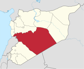
Talkalakh is a city in western Syria administratively belonging to the Homs Governorate as the capital of the Talkalakh District just north of the border with Lebanon and west of Homs. According to the Central Bureau of Statistics (CBS) Talkalakh had a population of 18,412 in 2004. Its inhabitants are predominantly Sunni Muslims, while the surrounding villages are mostly inhabited by Alawites. Most of the city's Sunni Muslim residents have fled as a result of the ongoing Syrian civil war.

Al-Mukharram District is a district of the Homs Governorate in central Syria. Administrative centre is the city of al-Mukharram. At the 2004 census, the district had a population of 52,068.

Wadi al-'Uyun is a town in northwestern Syria, administratively part of the Hama Governorate, located west of Hama.
Umm Jabab is a village in central Syria, administratively part of the Homs Governorate, south of Homs. Nearby localities include al-Mukharram to the north and Jubb al-Jarrah to the northeast. According to the Central Bureau of Statistics, Umm Jabab had a population of 1,209 in the 2004 census.
Al-Houz is a village in central Syria, administratively part of the Homs Governorate, located southwest of Homs. Situated at the southern edge of Lake Qattinah, nearby localities include Aqrabiyah to the southwest, Arjoun and al-Qusayr to the southeast, Kafr Mousa to the east and al-Ghassaniya to the northeast. According to the Central Bureau of Statistics (CBS), al-Houz had a population of 2,239 in the 2004 census. It is an Alawite village.
Sharqliyya is a village in central Syria, administratively part of the Homs Governorate, located northwest of Homs. Nearby localities include al-Qabu and al-Shinyah to the west, al-Taybah al-Gharbiyah to the northwest, Taldou to the northeast and Ghur Gharbiyah to the east.
Awj is a village in northern Syria, administratively part of the Hama Governorate, located in the Homs Gap southwest of Hama. Nearby localities include Aqrab and Tell Dahab to the east, Nisaf and Baarin to the north, Ayn Halaqim to the northwest, and Kafr Kamrah and Rabah to the south. According to the Syria Central Bureau of Statistics, Awj had a population of 4,222 in the 2004 census. Its inhabitants are predominantly Alawites.

Al-Mushrifah is a village in central Syria, administratively part of the Homs Governorate, located northeast of Homs, with a population of 14,868 in 2004. Nearby localities include Ayn al-Niser, Umm al-Amad and al-Mukharram to the east, and Talbiseh, al-Ghantu and Teir Maalah to the west. Outside the modern town is Tell el-Mishrife, the site of the ancient city-state of Qatna. It has a religiously mixed population of Sunni Muslims, Alawites and Christians. The village contains several mosques and two churches.
Al-Laqbah is a town in northwestern Syria, administratively part of the Hama Governorate, located west of Hama. It is situated along the edge of the Orontes River valley, on the main road between Masyaf and northern Syria. Nearby localities include Deir Mama to the south, Jubb Ramlah and Hanjur to the northeast, Deir Shamil to the north and al-Annazah to the west. According to the Syria Central Bureau of Statistics, al-Laqbah had a population of 1,908 in the 2004 census. Its inhabitants are predominantly Alawites.
Ayn al-Niser is a town in central Syria, administratively part of the Homs Governorate, located northeast of Homs. Nearby localities include al-Mishirfeh to the west, Ayn al-Dananir to the northwest, Izz al-Din to the north, al-Mukharram al-Fawqani to the east and Umm al-Amad to the southeast.

Abu Qubays is a former medieval castle and currently an inhabited village in northwestern Syria, administratively part of the Hama Governorate, located northwest of Hama. It is situated in the al-Ghab plain, west of the Orontes River. Nearby localities include Daliyah 21 kilometers to the west, al-Laqbah to the south, Deir Shamil to the southeast, Tell Salhab to the northeast and Nahr al-Bared further northeast. According to the Syria Central Bureau of Statistics (CBS), Abu Qubays had a population of 758 in the 2004 census. Its inhabitants are predominantly Alawites.
Al-Heraki is a village in central Syria, administratively part of the Homs Governorate, located northeast of Homs. Nearby localities include Umm al-Amad to the northwest, Umm Jbab and al-Mukharram to the north, Al-Sankari to the northeast, Furqlus to the southeast and al-Sayyid to the south. According to the Syria Central Bureau of Statistics (CBS), al-Heraki had a population of 2,238 in the 2004 census.
Al-Mukharram al-Tahtani is a village in central Syria, administratively part of the Homs Governorate, located northeast of Homs. Nearby localities include Ayn al-Niser to the west, Umm al-Amad to the southwest, al-Mukharram to the southeast and Danibah and Khunayfis to the north. According to the Syria Central Bureau of Statistics (CBS), al-Mukharram al-Tahtani had a population of 3,035 in the 2004 census.
Mas'udiyah is a village in central Syria, administratively part of the Homs Governorate, located northeast of Homs. Nearby localities include subdistrict center Jubb al-Jarrah to the south and Barri Sharqi to the northwest. According to the Syria Central Bureau of Statistics (CBS), Mas'udiyah had a population of 1,755 in the 2004 census. Its inhabitants are predominantly Alawites.
Mahrusah is a village in northern Syria, administratively part of the Hama Governorate, located west of Hama. Nearby localities include Jubb Ramlah to the north, Hanjur and Asilah to the northeast, Maarin to the east, Deir al-Salib to the southeast, Rabu to the south, Masyaf to the southwest and Deir Mama and al-Laqbah to the west. According to the Syria Central Bureau of Statistics, Mahrusah had a population of 6,579 in the 2004 census, making it the largest locality in the Jubb Ramlah subdistrict which consisted of 20 localities with a collective population of 39,814 in 2004. Its inhabitants are predominantly Alawites.
Tell al-Nabi Mando, known in archaeological literature as Tell Nebi Mend and also known as Qadesh after the Bronze-Age city which stood at almost the same location, is a village in central Syria, administratively part of the Homs Governorate, located southwest of Homs. It is situated on the eastern banks of the Orontes River. Nearby localities include al-Houz to the north, Kafr Mousa to the northeast, Arjoun to the east, al-Qusayr to the southeast, Zita al-Gharbiyah to the southwest, al-Aqrabiyah to the southwest and al-Naim to the northwest. According to the Syria Central Bureau of Statistics (CBS), Tell al-Nabi Mando had a population of 1,068 in the 2004 census. The village is adjacent to the ancient site of Qadesh, a name sometimes also used for the village, which abuts it to the north. It is an Alawite village.
Umm al-Amad is a village in central Syria, administratively part of the Homs Governorate. Nearby towns include al-Mukharram to the east, al-Mukharram al-Tahtani to the northeast, Danibah to the north, and al-Mishirfeh to the east. According to the Central Bureau of Statistics, Umm al-Amad had a population of 2,851. Its inhabitants are predominantly Shia Muslims.
Maksar al-Hisan is a village in northern Syria located east of Homs in the Homs Governorate. According to the Syria Central Bureau of Statistics, Maksar al-Hisan had a population of 811 in the 2004 census. Its inhabitants are predominantly Alawites.


