Jubbal

Last updated

Jubbal
Tehsil
Jubbal Palace.jpg
Jubbal Palace
India Himachal Pradesh location map.svg
Red pog.svg
Jubbal
Location in Himachal Pradesh, India
India location map.svg
Red pog.svg
Jubbal
Jubbal (India)
Coordinates: 31°06′34″N77°39′47″E / 31.1094667°N 77.6629967°E / 31.1094667; 77.6629967
CountryFlag of India.svg  India
State Himachal Pradesh
District Shimla
Founded byRaja Ugar Chand
Elevation
1,901 m (6,237 ft)
Population
 (2011)
  Total37,682 [1]
Languages
  Official Hindi
Time zone UTC+5:30 (IST)
Vehicle registration HP-10

Jubbal is a tehsil, town and a nagar panchayat [2] in Shimla district in the Indian state of Himachal Pradesh which shares its boundary with the state of Uttrakhand towards south-east. Jubbal is recognised as a major apple producing area in Shimla district along with Kotgarh, Kumarsain, Kotkhai and Chopal. It is famous for its Hindu temples, picturesque mountains and its royal palace situated in the town.

Contents

Geography

Jubbal, located at 31°06′34″N77°39′47″E / 31.1094667°N 77.6629967°E / 31.1094667; 77.6629967 [3] has an average elevation of 2200 metres (7220 feet). A small hill town, it is famous for its apple orchards and the Jubbal Palace. Jubbal has a combination of vast landscapes, thick woods, and buildings. It is located at an elevation of 1901 meters.

History

The history of Jubbal State goes back to the 12th century. Among the 18 Thakuries located in the valleys of Sutlej, Pabbar and Giri this Thakurai was of considerable importance. Rulers of Jubbal belong to the Rathore clan. During 12th century Ugar Chand, the Raja of Sirmoor State, had a summer palace in Soonpur, modern day Hatkoti, which is overlooked by the plateau of Sonnpur, on the right bank of the Pabbar river. While he was having pleasant company with his family he had to go back to Sirmaur leaving royal family behind. Due to heavy rainfall river Giri got flooded and capital of the state was swept away and the royal family lost its ancestral possessions the Sirmur State forever to a prince of Jaisalmer.

The princely state of Jubbal was founded in 1800. It was occupied by Nepal from 1803 to 1815 and by the British from 1832 to 1840. The rulers who belonged to the Rathore clan took the title of Rana. The last ruler Rana Baghat Chandra took the title of Raja in 1918.

Amongst all the rulers Rana Karam Chand was the most aggressive, who after being granted full ruling powers in 1854 started the expansionist approach by burning down the Kotis (large palatial wooden houses) and killing the local chieftains of the nearby adjoining areas mainly Bushahar state. The most important massacre being the burning down of 14 houses of the Khadola clan of nearby Kaina village which belonged to the Bushahar state. It was predominantly a warrior clan owning hundreds of acres of land and one day Rana Karam Chand got the news that the Khoonds (warriors) of the Kaina village has large reserves of food, silver, and gold. One fine day he sent his ministers to see whether the information is correct or not. To his surprise when the ministers came back from Kaina they brought down silverware with them in which they had eaten food. As a token of gratitude they were given every piece of silverware in which they have had their food. Seeing this Rana got angry and at the stroke of midnight burnt down all the 14 houses of Khadola clan. Only a single member of their clan survived.

Jubbal State had an area of 288 square miles and was famous for its dense forests of deodar trees. Today, Jubbal is reputed for its apple orchards which provide its residents their main source of income. The town of Jubbal is about 100 kilometres from Shimla.

Jubbal has also given the state of Himachal Pradesh a Chief Minister. Ram Lal Thakur of Barthata village was the Chief Minister [4] from 1975 to 1977 and again from 1980 to 1982.

Rulers of Jubbal State

The rulers of the princely state of Jubbal were: [5]

Demographics

Pahari is the native language here. Hindi and English are the official languages and are also spoken here.

Climate

Jubbal shows wide and sweeping variations in its landscape, ranging from lush green and thick woods to dry lands bereft of vegetation. The valley is also famous for its apple orchards. The region is generally cool throughout the year with temperatures ranging from 15 degrees to 30 °C during the summer and falling below zero degrees during the winter. The winters are especially harsh and snowfall is frequent.

Tourism

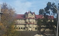
Major attractions in Jubbal include the namesake Jubbal Palace, [6] the Hateshwari mata temple, Chunjar peek, apple lodges of Badhal, Chhajpur, Nandpur region and Mahasu devta temple Hanol of Tiuni which is just 38 km from Jubaal town. The Jubbal Palace is best known for its architecture and citadel. A part of the palace, called the Rana's abode, is built in Chinese style with suspended attics and structures carved out of deodar timber. The modern wing of the palace has an Indo-European design and feel with convoluted wooden ceilings and the works. This palace which was the residence of the ruling Jubbal family has been turned into a heritage spot now.

The Hateshwari temple, is a two storied pagoda style structure believed to have been built by the Pandavas. Constructed around 800-1000 AD, the temple was renovated by the Jubbal rulers in the 19th century; the main idol of Hatkeshwari and the inner sanctum sanctorum were barely affected though.

Getting there

Traveling to Jubbal by road is the most preferred mode, because many state owned buses ply from Shimla to Jubbal. Buses and cabs are available for travel within the city. Private vehicles are also available from Shimla to Jubbal for moderate prices around 1000-2000 INR. The nearest narrow gauge railway line is at Shimla again, which is connected to Delhi by train. Jubbar Hatti airport provides irregular services, mainly due to fluctuating weather. You can obtain a more reliable service at Shimla airport which has direct flights to New Delhi.

See also

Nearby Cities and Towns :-

Related Research Articles

<span class="mw-page-title-main">Kullu</span> Town in Himachal Pradesh, India

Kullu is a municipal council town that serves as the administrative headquarters of the Kullu district of the Indian state of Himachal Pradesh. It is located on the banks of the Beas River in the Kullu Valley about 10 kilometres (6.2 mi) north of the airport at Bhuntar, Kullu.

The Hill States of India were princely states lying in the northern border regions of the British Indian Empire.

Katoch is a Chandravanshi Rajput clan. Their traditional areas of residence was Trigarta Kingdom, Jalandhar, Multan i.e. the areas of residence are mainly in the Indian states of Punjab, Uttarakhand, Himachal Pradesh and Jammu. and at Kangra Fort. They descent from the Trigarta dynasty mentioned in the Mahabharata. Historically, they ruled from Multan, Jalandhar, and Kangra. The Multan Fort (1000-800 B.C and Kangra fort were also built by Katoch clan, establishing their antiquity. Katochs have only 4 sub-clans that came into existence from Katoch Rajputs are Dadwal Dynasty, Guleria Dynasty, Sibaia Dynasty, Jaswal Dynasty.

<span class="mw-page-title-main">Arki, India</span> Town in Himachal Pradesh, India

Arki is a town, tehsil and Nagar panchayat in Solan district of Himachal Pradesh, India. The town is known for its fort built in the late 18th century when Arki was the capital of the erstwhile princely hill state of Baghal.

Kotkhai is a town and a Nagar Panchayat in Shimla district in the Indian state of Himachal Pradesh.The name Kotkhai is derived from Hindi and Urdu language where the name "Kot" means Kings Palace and "Khai" means depth, therefore "Kotkhai" means "Kings palace situated in depth". It is a tehsil with around 40 villages under its administration. The whole tehsil is known for quality apple production. Kotkhai is also known for its fairs and traditional values, people of Kotkhai are really devotional towards Devtas where each villages believes in different forms of Devtas.

<span class="mw-page-title-main">Sarahan</span>

Sarahan is a small town in Himachal Pradesh of India. It is the site of the Bhimakali Temple, originally known as Bhimadevi Temple, dedicated to the mother goddess Bhimakali, presiding deity of the rulers of the former Bushahr State. The temple is situated about 170 kilometres from Shimla and is one of 51 Shakti Peethas. The town is known as the "gateway of Kinnaur" it being near the old Indo-Tibetan Road. Seven kilometers below Sarahan is the river Satluj. Sarahan is identified with the Shonitpur mentioned in Puranas. Sarahan Bushahr has been the summer capital of Bushahr kingdom, with Rampur Bushahr considered the winter capital. The former Chief Minister of Himachal Pradesh Shree Virbhadra Singh is a member of royal family and is popularly known as "Raja Sahab" at Sarahann. He has been member of the Assembly/Parliament since 1962 and has held the post of Chief Minister six times. His wife Rani Pratibha Devi is also a member of Assembly.

<span class="mw-page-title-main">Sirmur State</span> Princely state of India

Sirmur was an independent kingdom in India, founded in 1616, located in the region that is now the Sirmaur district of Himachal Pradesh. The state was also known as Nahan, after its main city, Nahan. The state ranked predominant amongst the Punjab hill States. It had an area of 4,039 km2 and a revenue of 300,000 rupees in 1891.

<span class="mw-page-title-main">Chanshal Pass</span>

The Chanshal Pass, or Chanshal Valley, links Dodra Kwar and Rohru (Chirgaon) in the Shimla district of the Indian state of Himachal Pradesh. The pass sits atop Chanshal Peak, which at 4,520 metres (14,830 ft) is the highest peak in the Shimla district. The pass remains open from May to november and is covered with snow for the rest of the year.

<span class="mw-page-title-main">Thakur Ram Lal</span> Indian politician

Thakur Ram Lal was an Indian politician and a leader of the Indian National Congress in Himachal Pradesh.

<span class="mw-page-title-main">Karsog</span> Town/village in Himachal Pradesh, India

Karsog is a town and municipal area in the state of Himachal Pradesh in northern India.

<span class="mw-page-title-main">Hatkoti</span> Village in Himachal Pradesh, India

Hatkoti is a village in Shimla district of Himachal Pradesh, India. It is a village located at the banks of Pabbar River and it is about 102 kilometres away from Shimla city. Hatkoti is also famous for Hateshwari temple and Sawra Kuddu Hydro Electric Project.

Bamta is a panchayat in Chopal in the district of Shimla, Himachal Pradesh, India.

<span class="mw-page-title-main">Kumarsain</span> Town in Himachal Pradesh, India

Kumarsain, also known as Kumharsain, is a sub-division, a tehsil and a town in Shimla District in the Indian state of Himachal Pradesh. Formerly under the British Raj, it was the capital of princely state of Kumharsain, which was one of the several states of the Punjab States Agency.It is about 80 km from Shimla and famous for apple and cherry orchards.

<span class="mw-page-title-main">Kuthar</span>

Kuthar, formerly Krishangarh, is located in the Solan district of Himachal Pradesh. Krishangarh (Kuthar) is situated on the MDR-75 i.e. Shalaghat-Arki-Kunihar-Kuthar-Patta-Brotiwala adjoining Sabathu, Kasauli area. Krishangarh is an administrative division of Solan district having sub-tehsil status.

<span class="mw-page-title-main">Tourism in Himachal Pradesh</span> Tourism in the Indian state of Himachal Pradesh

Tourism in Himachal Pradesh relates to tourism in the Indian state of Himachal Pradesh. This is popularly renowned for its Himalayan landscapes and popular hill-stations. Many outdoor activities such as rock climbing, mountain biking, paragliding, ice-skating, trekking, rafting, and heli-skiing are popular tourist attractions in Himachal Pradesh.

Tikkar is a sub-tehsil which falls under Rohru tehsil in Shimla district of Himachal Pradesh state, India. It is 92 km (57 mi) east of the district headquarters and the state capital Shimla city. The area pin code is 171203 and the postal head office is situated at Tikkar town. Tikkar is surrounded by Nankhari Tehsil towards the west, Chauhara Tehsil towards the north, Jubbal Kotkhai Tehsil towards the west. Shimla, Solan, Nahan, Kalka are the nearby cities from here. It comes under Shimla parliamentary constituency for Lok Sabha and Jubbal Kotkhai assembly constituency for Himachal Pradesh Vidhan Sabha.

Mangal is a former princely state in north India ruled by Chandravanshi Sen Rajputs.Mangal state like Mandi State was an off shoot of Suket State. Rana Surender Singh is its present head.

His Highness Raja Sir Anand Chand was the 44th Raja of Bilaspur. He was a Member of Parliament, representing Bihar in the Rajya Sabha, the upper house of India's Parliament as a member of the Indian National Congress.

Jubbal State was a non-salute state of the Simla Hill States Superintendency of the Punjab States Agency. Thought to have been founded in the twelfth century, it merged with the Indian Union in 1948.

The Rajputs in Himachal Pradesh are members of the Rajput community living in the North Indian Himalayan state of Himachal Pradesh. They ruled a majority of kingdoms of the region and even dominate in Himachal Pradesh politics. The kingdoms of the Hill States of India were mostly in the present day state of Himachal Pradesh, and mostly had Rajput rulers. All of the Chief Ministers who served Himachal Pradesh except for Shanta Kumar belong to the Rajput caste. The Rajputs of Himachal Pradesh fought battles with Tughlaq, Mughal, and Sikh forces, most notable being the Battle of Bhangani, when the Hill States made an alliance against the Sikhs. While some Rajput kingdoms and clans have a long history in Himachal Pradesh, others were established due to the Rajput migrations to the hill regions mostly due to the Islamic invasions.

References

  1. "Census India". Archived from the original on 14 May 2007. Retrieved 10 March 2013.
  2. "List of Municipalities / Urban Local Bodies in Himachal Pradesh". Archived from the original on 2 August 2013. Retrieved 2 December 2013.
  3. Falling Rain Genomics, Inc - Jubbal
  4. "Himachal Pradesh Legislative Assembly". Legislative Bodies in India website. Archived from the original on 1 March 2012. Retrieved 10 January 2010.
  5. Rulers
  6. "HP Tourism Development Corporation Ltd". Archived from the original on 19 July 2013. Retrieved 21 June 2013.