
Himachal Pradesh is a state in the northern part of India. Situated in the Western Himalayas, it is one of the eleven mountain states and is characterized by an extreme landscape featuring several peaks and extensive river systems. Himachal Pradesh is the northernmost state of India and shares borders with the union territories of Jammu and Kashmir and Ladakh to the north, and the states of Punjab to the west, Haryana to the southwest, Uttarakhand to the southeast and a very narrow border with Uttar Pradesh to the South. The state also shares an international border to the east with the Tibet Autonomous Region in China. Himachal Pradesh is also known as 'Dev Bhoomi' or 'Land of God' and 'Veer Bhoomi' which means 'Land of Braves'.

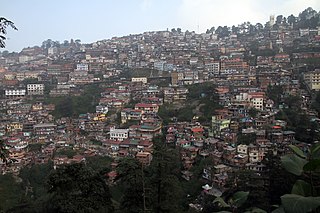
Shimla is the capital and the largest city of the Northern Indian state of Himachal Pradesh. In 1864, Shimla was declared as the summer capital of British India. After independence, the city became the capital of Punjab and was later made the capital city of Himachal Pradesh. It is the principal commercial, cultural and educational centre of the state. It was the capital city in exile of British Burma from 1942 to 1945.

Solan is a city in the Indian state of Himachal Pradesh and the district headquarters of Solan district. The 3rd largest Municipal Corporation of Himachal Pradesh after Shimla and Dharamshala, it is located 45.5 kilometres (28 mi) south of the state capital, Shimla, and at an average elevation of 1,550 metres (5,090 ft). The hill-town is named after the Hindu goddess Shoolini Devi ~ who is a manifestation of Goddess Durga in Her warrior aspect. Shoolini literally means 'the goddess wielding the spear'.. Every year in June, a fair venerating the Goddess is held, featuring a 3-day mela at the central Thodo ground. Solan was the capital of the erstwhile princely state, Baghat.

Manali is a town in the Indian state of Himachal Pradesh. It is situated in the northern end of the Kullu Valley, formed by the Beas River. The town is located in the Kullu district, approximately 270 kilometres (170 mi) north of the state capital of Shimla and 544 kilometres (338 mi) northeast of the national capital of Delhi. With a population of 8,096 people recorded in the 2011 Indian census Manali is the beginning of an ancient trade route through Lahaul and Ladakh, over the Karakoram Pass and onto Yarkand and Hotan in the Tarim Basin of China. Manali is a popular tourist destination in India and serves as the gateway to the Lahaul and Spiti district as well as the city of Leh in Ladakh.
Shimla is a district in the state of Himachal Pradesh in northern India. Its headquarters is the state capital of Shimla. Neighbouring districts are Mandi and Kullu in the north, Kinnaur in the east, Uttarakhand in the southeast, Solan to the southwest and Sirmaur in the south. The elevation of the district ranges from 987 metres (3,238 ft) to 4,500 metres (14,764 ft).
Ghumarwin is a town and a municipal council in Bilaspur district in the North Indian Hill State of Himachal Pradesh and is the second largest town of the entire district. The town is an anchor point for commuters between Bilaspur and Hamirpur and other parts of the state. Situated primarily between the Hills of Lower Central Himalayas, Ghumarwin is situated at an average elevation of 700 metres or about 2300 ft. above sea level. It is one of the biggest commercial centres of Bilaspur District and one can find all kinds of shops, stores, services etc. here.

Jubbal is a tehsil, town and a nagar panchayat in Shimla district in the Indian state of Himachal Pradesh which shares it's boundary with the state of Uttrakhand towards south-east. Jubbal is recognised as a major apple producing tehsil in Shimla district along with Kotgarh, Kumarsain, Kotkhai and Chopal. It is famous for its Hindu temples, picturesque mountains and its royal palace situated in the town.
Rohru is a town and a municipal committee in Shimla district in the Indian state of Himachal Pradesh. It is at the banks of the Pabbar River, and it is about 115 km from Shimla city. Rohru is famous for its apples, treking and trout fishing. The hatchery is at Dhamwari, 25 km upstream of Rohru town. The Nazeru Devta's temple is in Shakli, 15 km from Rohru. Devta Morish temple is in Rantari, 17 km upstream and Devta Shikru Maharaj's temple in middle of the town.
Sundar Nagar is a town and a municipal council in Mandi district in the Indian state of Himachal Pradesh. Formerly it was a princely state, known as Suket.
Rampur Bushahr is a town and a municipal council in Shimla district in the Indian state of Himachal Pradesh. It is about 130 km from Shimla and is well connected with NH 5 which passes through Theog, Narkanda and Kumarsain.

Chandar Nahan is a high altitude lake which is located in district Shimla, tehsil Rohru, about 4,260 m (13,980 ft) above sea level. It is surrounded by snow for a long time and is the source of the river Pabbar.
Jogindernagar, or Jogindar Nagar, is a municipality in Mandi district in the Indian state of Himachal Pradesh. Named after Raja Joginder Sen, the hill station is the terminus of the 163-kilometre-long (101 mi) Kangra Valley narrow-gauge railway. Jogindernagar is the third-largest city in the district. The only city in Asia with three hydro-electric power stations, its nickname is "The City of Powerhouses".

Himachal Pradesh is extremely rich in its hydroelectricity resources. The state has about twenty five percent of the national potential. About 27,436 MW of hydroelectric power can be generated in the state by the construction of various hydroelectric projects on the five perennial river basins. Out of total hydroelectric potential of the state, 10,519 MW is harnessed so far, out of which only 7.6% is under the control of Himachal Pradesh Government while the rest is exploited by the Central Government. The state government has been giving the highest priority for its development, since hydroelectric generation can meet the growing need of power for industry, agriculture and rural electrification. It is also the biggest source of income to the state as it provides electricity to other states.

State Highway 10, commonly referred to as HP SH 10 or Theog-Hatkoti road, is a normal state highway that runs through Shimla district in the state of Himachal Pradesh, India. This state highway touches the cities of Theog, Kotkhai, Jubbal, Hatkoti, Rohru. The length of State Highway 10 is 80 km. The road is considered as a lifeline for apple producing areas like Jubbal, Kotkhai and Rohru.

Hatkoti is a village in Shimla district of Himachal Pradesh, India. It is a village located at the banks of Pabbar River and it is about 102 kilometres away from Shimla city. Hatkoti is also famous for Hateshwari temple and Sawra Kuddu Hydro Electric Project.
Arhal is a village in Shimla district in the Indian state of Himachal Pradesh. It is a located near the town of Rohru and is about 125 kilometres (78 mi) away from Shimla and 8 km from Rohru. On 1–3 January 2016, there was the celebration of the festival Shaant Maha Yagya of Devi jaga mata of Arhal which came after 47 years. The valley of Arhal is known for its natural environment and sites.
Bamta is a panchayat in Chopal in the district of Shimla, Himachal Pradesh, India.

Kumarsain, also known as Kumharsain, is a town in Shimla District in the Indian state of Himachal Pradesh. Formerly it was a princely state of the British Raj and was one of the several states of the Punjab States Agency. It is about 80 km from Shimla and famous for apple and cherry orchards.
Lower Koti is a small village within the town of Rohru, in the Indian state of Himachal Pradesh.
Rohru is one of the 68 constituencies in the Himachal Pradesh Legislative Assembly of Himachal Pradesh a northern state of India. Rohru is also part of Shimla Lok Sabha constituency.

