Jubilee Bridge (Innisfail)

Last updated

Jubilee Bridge
Coordinates 17°31′31″S146°01′59″E / 17.5252°S 146.0330°E / -17.5252; 146.0330 Coordinates: 17°31′31″S146°01′59″E / 17.5252°S 146.0330°E / -17.5252; 146.0330
CarriesVehicle, bicycle and pedestrian traffic
Crosses South Johnstone River
Locale Innisfail, Queensland, Australia
Characteristics
Width15.8 m (52 ft)
History
Construction costA$21.6 million
Opened3 September 2011 (2011-09-03)
ReplacesJubilee Bridge (1923-2010)

The Jubilee Bridge spans the South Johnstone River connecting Innisfail and East Innisfail, Queensland, Australia. The bridge was constructed in 2011, replacing an earlier bridge built in 1923 which marked the 50th anniversary of the establishment of Innisfail. [1]

Contents

History

Johnstone River Ferry

Johnstone River Ferry at Geraldton Johnstone River Ferry at Geraldton.jpg
Johnstone River Ferry at Geraldton
Early construction of the Jubilee Bridge Early construction of the Jubilee Bridge.jpg
Early construction of the Jubilee Bridge

The idea of constructing a bridge in this location was first raised in 1907 by the Johnstone Shire Chairman, Charles Edward Joddrell. The emerging timber and agricultural industry was hampered by poor shipping service associated with difficulties maintaining the nearby harbour at Mourilyan. The proposal was met with fierce opposition within the community, and sparked an ongoing debate over the development of Mourilyan Harbour, and the merits of a connecting tramline to Geraldton Wharf – Geraldton being the earlier name for Innisfail.

The Queensland government had already promised funds for the construction of a bridge at the end of Rankin Street, and for some; the plan for a composite road and tramway bridge leading to East Geraldton from the ferry site became more important than the planned harbour facilities. Lack of bridges was a continuing problem for residents of the district. While the use of ferries was common, it was not without its share of accidents and tragedies.

Just as support for the bridge proposal appeared at its lowest, the last ferryman, Larry Breen – an East Geraldton resident – and his wife, scoured the district with a petition asking for the construction of the bridge. [2]

Jubilee Bridge, 1923

There were ongoing concerns regarding a loan to construct a bridge over the south branch of the river at Innisfail. In 1911 the Home secretary said the Shire must reduce its indebtedness in order for the Government to consider a fresh application next year. [3]

The Jubilee Bridge was officially opened on 28 September 1923 by the Queensland Premier Ted Theodore who was driven in a car through the ribbon. The bridge was decorated with flags, streamers and palms. The Chairman of the Johnstone Shire Council, Leontine Joseph Duffy, announced the bridge had cost £32,000 of which £20,000 was spent in Innisfail. One of the bridge piers was 72 feet (22 m) deep, the deepest on any traffic bridge in Australia. [4]

Looking west towards town and the bridge, Innisfail, 1930 StateLibQld 1 258849 Looking west towards town and the bridge, Innisfail, 1930.jpg
Looking west towards town and the bridge, Innisfail, 1930

However, with a few years, the bridge showed signs of sinking with a report by engineers confirming subsidence of the piers in 1928. A 4-tonne (4-short-ton) weight limit was introduced on the bridge. [5] Repairs costing £2000 were required. [6]

As there was no footbridge, there were soon demands from as early as 1933 for a footbridge to be added to separate the pedestrians from the vehicles and horses. [7] However, it was not until 1940 that the Shire Council attempted to borrow £7140 for the Queensland Government to fund bridge strengthening and the addition of a footbridge. Funding must not have been available as it was not until 1949 that the council attempted to build the footbridge but was then unable to obtain the required steel in post-World War II Australia. [8] In 1952, another engineer's report suggested that the bridge was nearing the end of its life and the loan funds to be expended to do more repairs to keep the bridge open, while plans and funding were sought to build a replacement bridge. [9]

However, no replacement bridge was built and by February 2010, Councillor Bill Shannon announced that the bridge was sinking at a time when adequate funding for a new bridge was uncertain. [10] The Jubilee Bridge was closed on 21 May 2010 after a review found the bridge to be unsafe. [11] The bridge's closure created a 6 kilometres (3.7 mi) detour for those travelling between Innisfail and East Innisfail. [12]

Jubilee Bridge, 2011

The new bridge was opened on 3 September 2011 with a ceremony attended by the then Premier, Anna Bligh, Queensland MP, Curtis Pitt and local Mayor Bill Shannon. [13] [14] The new bridge faithfully reproduces the Art deco features of the original bridge. [12]

Related Research Articles

Innisfail, Queensland Town in Queensland, Australia

Innisfail is a town and locality in the Cassowary Coast Region in Far North Queensland, Australia. The town was originally called Geraldton until 1910. It is the major township of the Cassowary Coast Region and is well renowned for its sugar and banana industries, as well as for being one of Australia's wettest towns. In March 2006, Innisfail gained worldwide attention when severe Tropical Cyclone Larry passed over causing extensive damage. In the 2016 census, the town of Innisfail had a population of 7,236 people.

North Coast railway line, Queensland railway line in Queensland, Australia

The North Coast railway line is a narrow gauge railway line in Queensland, Australia. It commences at Roma Street station, Brisbane, and largely parallels the Queensland coast to Cairns in Far North Queensland. The line is electrified between Brisbane and Rockhampton. Along the way, the 1680 km railway passes through the numerous towns and cities of eastern Queensland including Nambour, Bundaberg, Gladstone, Rockhampton, Mackay and Townsville. The line though the centre of Rockhampton runs down the middle of Denison Street.

Shire of Mareeba Local government area in Queensland, Australia

The Shire of Mareeba is a local government area at the base of Cape York Peninsula in Far North Queensland, inland from Cairns. The shire, administered from the town of Mareeba, covered an area of 53,491 square kilometres (20,653.0 sq mi), and existed as a local government entity from 1879 until 2008, when it amalgamated with several councils in the Atherton Tableland area to become the Tablelands Region.

Shire of Eacham Local government area in Queensland, Australia

The Shire of Eacham was a local government area of Queensland. It was located on the Atherton Tableland, a plateau forming part of the Great Dividing Range west of the city of Cairns. The shire, administered from the town of Malanda, covered an area of 1,126.4 square kilometres (434.9 sq mi), and existed as a local government entity from 1910 until 2008, when it amalgamated with several other councils in the Tableland area to become the Tablelands Region.

Shire of Johnstone Local government area in Queensland, Australia

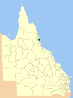
The Shire of Johnstone was a local government area of Queensland. It was located on the Coral Sea coast about 90 kilometres (56 mi) south of the city of Cairns. The shire, administered from the town of Innisfail, covered an area of 1,639.1 square kilometres (632.9 sq mi), and existed as a local government entity from 1881 until 2008, when it amalgamated with the Shire of Cardwell to form the Cassowary Coast Region.

Shire of Cardwell Local government area in Queensland, Australia

The Shire of Cardwell was a local government area of Queensland. It was located on the Coral Sea coast about halfway between the cities of Cairns and Townsville. The shire, administered from the town of Tully, covered an area of 3,062.2 square kilometres (1,182.3 sq mi), and existed as a local government entity from 1884 until 2008, when it amalgamated with the Shire of Johnstone to form the Cassowary Coast Region.

Cassowary Coast Region Local government area in Queensland, Australia

The Cassowary Coast Region is a local government area in the Far North Queensland region of Queensland, Australia, south of Cairns and centred on the towns of Innisfail, Cardwell and Tully. It was created in 2008 from a merger of the Shire of Cardwell and the Shire of Johnstone.

Innisfail Court House

Innisfail Court House is a heritage-listed court house at 10 Edith Street, Innisfail, Cassowary Coast Region, Queensland, Australia. It is the town’s third court house. It was designed in the inter-war classical style by the Department of Public Works (Queensland) and built in 1939 by day labour. The current court house is a two-storeyed brick building with a corrugated-iron roof. It was added to the Queensland Heritage Register on 13 January 1995.

Johnstone River river in Queensland, Australia

The Johnstone River, comprising the North Johnstone River and the South Johnstone River, is a river system located in Far North and North Queensland, Australia.

East Innisfail, Queensland Suburb of Cassowary Coast Region, Queensland, Australia

East Innisfail is a suburban locality in the Cassowary Coast Region, Queensland, Australia. In the 2016 census, East Innisfail had a population of 1,855 people.

Michael Martin Clancy Australian priest

Father Michael Martin Clancy OSA (1868–1931) was an Irish-Australian Roman Catholic priest. He was the first resident Parish Priest in Geraldton, a town and parish in North Queensland, Australia. He was an inspirational parish priest who developed the Parish, established Catholic education in the Johnstone River district and built Innisfail's present Mother of Good Counsel Church. He played an important part in the development in the town and the district. Father Clancy was enthusiastically involved in the life of the town, local committees and governing bodies. He was instrumental in the changing of Geraldton's name to Innisfail in 1910. He also advocated for forging a link to the Atherton Tableland and the use of Mourilyan Harbour by shipping. Mount Father Clancy Garreth McGonnell near the Beatrice River was named in his honour.

'Sugar Lighters in the Johnstone River, Queensland' In the early days of settlement at Geraldton [now Innisfail], the Johnstone River had a sand bar at the mouth and several shallow stretches in the river. This caused difficulties for shipping. Large ships had to either anchor at the mouth of the river and wait for a suitable high tide so that the bar could be crossed or anchor in Mourilyan Harbour to the south. The problem of large ships being unable to enter the river made it difficult for bags of sugar from the district sugar mills to be transported to southern refineries. To overcome this problem, shallow draft steam ships and lighters [often called sugar lighters] were used to carry the bags of sugar down the Johnstone and out to meet larger ships standing off the coast. or in nearby ports, mainly Cairns. These larger ships then transported the cargo to its destination. These small ships became known as "The Mosquito Fleet".

Tom See Poy Chinese-Australian storekeeper

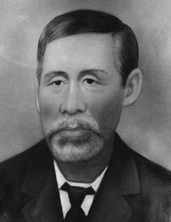
Tom See Poy, also known as Taam Sze-Pui, was a Chinese Australian storekeeper in Innisfail, Queensland, Australia. At its peak, his department store See Poy & Sons was one of the foremost department stores in north Queensland.

Cardstone is a rural locality in the Cassowary Coast Region in Queensland, Australia. It is 50 kilometres (31 mi) south-west of Innisfail.

Mourilyan Harbour Suburb of Cassowary Coast Region, Queensland, Australia

Mourilyan Harbour is a coastal locality and harbour within the Cassowary Coast Region, Queensland, Australia. In the 2016 census, Mourilyan Harbour had a population of 156 people.

Patrick Leahy (Australian politician) Australian politician

Patrick James Leahy was a journalist, and member of both the Queensland Legislative Council and the Queensland Legislative Assembly.

Innisfail Advocate

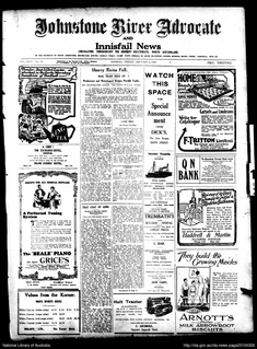
The Innisfail Advocate is a newspaper published in Innisfail, Queensland, Australia.

McCowats Farm

McCowat's Farm is a heritage-listed plantation at McCowat Road, Garradunga, Cassowary Coast Region, Queensland, Australia. It was built in 1920 by William Purdy. It is also known as Koodla. It was added to the Queensland Heritage Register on 21 October 1992.

Johnstone Shire Hall

Johnstone Shire Hall is a heritage-listed town hall at 70 Rankin Street, Innisfail, Cassowary Coast Region, Queensland, Australia. It was designed by Hill & Taylor and built from 1935 to 1938 by Van Leeuwen Brothers. It was added to the Queensland Heritage Register on 13 January 1995.

St Saviours Anglican Church, South Johnstone church building in Queensland, Australia

St Saviour's Anglican Church is a heritage-listed former church building at 26 Hynes Street, South Johnstone, Cassowary Coast Region, Queensland, Australia. It was built from 1938 to 1939 by Mose Romano. It was added to the Queensland Heritage Register on 24 September 2004.

References

  1. Dixon, Natalie (5 September 2011). "Innisfail's Jubilee Bridge opens". Cairns Post. Retrieved 20 April 2012.
  2. Dorothy Jones. Hurricane Lamps and Blue Umbrellas: A history of the Shire of Johnstone to 1973. pp. ?–?. ISBN   9780909920043.
  3. "?". Courier Mail. 1911.
  4. "INNISFAIL BRIDGE". The Queenslander . Brisbane: National Library of Australia. 29 September 1923. p. 40. Retrieved 3 February 2015.
  5. "INNISFAIL JUBILEE BRIDGE". Townsville Daily Bulletin . Qld.: National Library of Australia. 25 July 1928. p. 4. Retrieved 3 February 2015.
  6. "OPPORTUNITY REPORT". Construction and Local Government Journal (Sydney, NSW : 1913–1930) . Sydney: National Library of Australia. 2 January 1929. p. 16. Retrieved 3 February 2015.
  7. "JUBILEE BRIDGE". The Cairns Post . Qld.: National Library of Australia. 29 April 1933. p. 8. Retrieved 3 February 2015.
  8. "STEEL SUPPLIES". The Cairns Post . Qld.: National Library of Australia. 8 November 1949. p. 4. Retrieved 3 February 2015.
  9. "INNISFAIL SENSATION". The Cairns Post . Qld.: National Library of Australia. 26 May 1952. p. 6. Retrieved 3 February 2015.
  10. Julie Lightfoot (6 February 2010). "Rates rise to pay for Innisfail bridge". The Cairns Post. Retrieved 20 April 2012.
  11. Jessica Mawer (21 May 2010). "Jubilee Bridge to close tonight". ABC News. Australian Broadcasting Corporation. Retrieved 20 April 2012.
  12. 1 2 "Jubilee Bridge, Innisfail" (PDF). Humes. Retrieved 3 February 2015.
  13. "Innisfail's Jubilee Bridge is Open to Traffic". Cassowary Coast Regional Council. 2 September 2011. Retrieved 20 April 2012.[ dead link ]
  14. Bligh, Anna (3 September 2011). "Innisfail unites with new Jubilee Bridge". Archived from the original on 3 August 2017. Retrieved 3 August 2017.

Bibliography

Further reading