
Frankfort is the capital of the U.S. state of Kentucky and the seat of Franklin County. It is a home rule-class city. The population was 28,602 at the 2020 census, making it the thirteenth-most populous city in Kentucky. Located along the Kentucky River, Frankfort is the principal city of the Frankfort, Kentucky Micropolitan Statistical Area, which includes all of Franklin and Anderson counties.
Carrollton is a home rule-class city in—and the county seat of—Carroll County, Kentucky, United States, at the confluence of the Ohio and Kentucky rivers. The population was 3,938 at the 2010 census.

Cumberland is a home rule-class city in Harlan County, Kentucky, in the United States. The population according to the 2010 Census was 2,237, down from 2,611 at the 2000 census. The city sits at the confluence of Looney Creek and the Poor Fork Cumberland River.

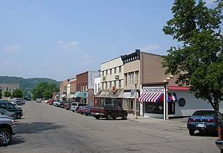
Harlan is a home rule-class city in and the county seat of Harlan County, Kentucky, United States. The population was 1,745 at the 2010 census, down from 2,081 at the 2000 census.

Cynthiana is a home rule-class city in Harrison County, Kentucky, in the United States. The population was 6,402 at the 2010 census. It is the seat of its county.

Madisonville is a home rule-class city in and the county seat of Hopkins County, Kentucky, United States, located along Interstate 69 in the state's Western Coal Fields region. The population was 19,591 at the 2010 census. Madisonville is a commercial center of the region and is home to Madisonville Community College.
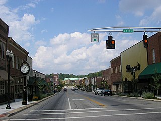
London is a home rule-class city in Laurel County, Kentucky, in the United States. It is the seat of its county. The population was 8,053 at the time of the 2020 census. It is the second-largest city named "London" in the United States and the fourth-largest in the world. It is part of the London, Kentucky micropolitan area. Of the seventeen micropolitan areas in Kentucky, London is the largest; the London micropolitan area's 2010 Census population was 126,368. London is also home to the annual World Chicken Festival that celebrates the life of Colonel Sanders and features the world's largest skillet.

Beattyville is a home rule class city in, and the county seat of, Lee County, Kentucky, United States. The city was formally established by the state assembly as "Beatty" in 1851 and incorporated in 1872. It was named for Samuel Beatty, a pioneer settler. The population was 1,307 at the 2010 census and an estimated 1,206 in 2018.

Hazard is a home rule-class city in, and the county seat of, Perry County, Kentucky, United States. The population was 5,263 at the 2020 census.

Somerset is a home rule-class city in Pulaski County, Kentucky, United States. The city population was 11,924 according to the 2020 census. It is the seat of Pulaski County.

Northern Kentucky is an urban area in the U.S. Commonwealth of Kentucky consisting of the southern part of the Cincinnati metropolitan area. The three main counties of the area are Boone, Kenton, and Campbell, all along the Ohio River across from Cincinnati, Ohio. Other counties frequently included in Northern Kentucky include Bracken, Grant, Gallatin and Pendleton. Of Greater Cincinnati's over two million residents, over 450,000 of them live in Northern Kentucky as of 2020, primarily in the northernmost counties. The largest cities in the region are Covington, Florence, and Independence.

Oneida is an unincorporated community and census-designated place (CDP) in Clay County, Kentucky, United States. Its population was 238 at the 2020 census. It is the home of Oneida Baptist Institute. Goose Creek, the Red Bird River, and Bullskin Creek confluence to form the South Fork of the Kentucky River a few hundred yards from the center of the town.

Breaks Interstate Park, also known as "the Breaks," is a bi-state state park located partly in southeastern Kentucky and southwestern Virginia in the Jefferson National Forest, at the northeastern terminus of Pine Mountain. The land is managed by an interstate compact between the states of Virginia and Kentucky. It is one of two interstate parks in the United States operated jointly under a compact rather than as two separate state park units. The Virginia Department of Conservation and Recreation and the Kentucky Department of Parks are still major partner organizations.

Adolphus is an unincorporated community in southern Allen County, Kentucky, United States. The community is due south of Scottsville. The community is primarily a rural area on farmland.
Fedscreek is an unincorporated community and coal town in Pike County, Kentucky, United States.

Freeburn is a census-designated place, unincorporated community and coal town in Pike County, Kentucky, United States.

Meta is an unincorporated community in Pike County, Kentucky. Meta is located at the junction of Kentucky Route 1426 and Kentucky Route 2169 7.7 miles (12.4 km) northeast of Pikeville. The community had a post office from 1896 to 1959.
Raccoon City is an unincorporated community located in Pike County, Kentucky, United States.
Dunmor is an unincorporated community and census-designated place (CDP) in Muhlenberg and Logan counties, Kentucky, United States. As of the 2020 census it had a population of 322.

The Cincinnati metropolitan area is a metropolitan area with its core in Ohio and Kentucky. Its largest city is Cincinnati and includes surrounding counties in the U.S. states of Ohio, Kentucky, and Indiana.


