
Garhwal is the western region and administrative division of the Indian state of Uttarakhand which is home to the Garhwali people. Lying in the Himalayas, it is bounded on the north by Tibet, on the east by Kumaon region, on the south by Uttar Pradesh state, and on the northwest by Himachal Pradesh state. It includes the districts of Chamoli, Dehradun, Haridwar, Pauri Garhwal, Rudraprayag, Tehri Garhwal, and Uttarkashi. The people of Garhwal are known as Garhwali and speak the Garhwali language. The administrative center for Garhwal division is the town of Pauri. The Divisional Commissioner is the administrative head of the Division, and is a senior Indian Administrative Service officer. As the administrative head of the division, the Commissioner is overall incharge of the 7 districts in the Garhwal region of Uttarakhand, and is aided in his duties by an Additional Commissioner and the District Magistrates. Vinod Sharma is currently the Divisional Commissioner of the Garhwal Division.
Champawat is a town and a Nagar Palika Parishad in Champawat district in the state of Uttarakhand, India. It is the administrative headquarters of Champawat district. The town was the former capital of the Kumaon Kingdom.
Didihat is a town and a Nagar Palika in Pithoragarh District in the state of Uttarakhand, India. It is one of the eleven administrative subdivisions of Pithoragarh district and also serves as its administrative headquarters. With a population of 6522, Didihat is located at a distance of 520 km (320 mi) from the state capital Dehradun.

Nainital district is a district of Uttarakhand state, India. The headquarters is at Nainital.

Bageshwar District is a district of Uttarakhand state in northern India. The town of Bageshwar is the district headquarters. The district of Bageshwar was established in the year 1997. Prior to this, Bageshwar was part of Almora district.

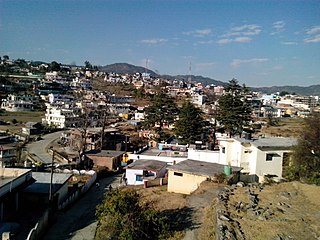
Almora is a municipal board and a cantonment town in the Almora district in the state of Uttarakhand, India. It is the administrative headquarters of Almora district. Almora is located on a ridge at the southern edge of the Kumaon Hills of the Himalaya range, at a distance of 363 km from the national capital New Delhi and 415 km via Saharanpur Rd, 351 km via NH109 and 388.6 km via Ambala- Dehradun- Haridwar Rd from the state capital Dehradun. According to the provisional results of the 2011 national census of India, Almora has a population of 35,513. Nestled within higher peaks of the Himalaya, Almora enjoys a year-round mild temperate climate.

Kirtinagar is a town and a Nagar Panchayat and a Taluk in Tehri Garhwal district in the Indian state of Uttarakhand.
Kotdwar is a tehsil in Pauri Garhwal district in Indian state of Uttarakhand. Its old name was Khohdwar, which means the gateway of the river Khoh: as Kotdwar is located on the bank of river Khoh so it was named Kotdwar. It is situated in the south-western part of state and is one of the main entrance points in the state of Uttarakhand. Kotdwar Railway station, established in 1890 by the Britishers is one of the oldest railway stations of the country. Being the gateway of Himalayan Region, Kotdwar rail route was used for timber transportation from Himalayan Region. First Passenger train ran in the year 1901.
Landhaura is a town and a nagar panchayat in Haridwar district in the Indian state of Uttarakhand.
Dehradun Cantonment is a cantonment town in Dehradun district in the state of Uttarakhand, India. It was established in 1913.

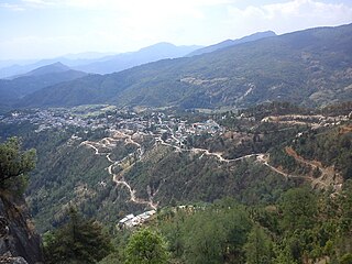
Kausani is a hill station and Village situated in Bageshwar district in the state of Uttarakhand, India. It is famous for its scenic splendour and its spectacular 300 km-wide panoramic view of Himalayan peaks like Trisul, Nanda Devi and Panchchuli. Mahatma Gandhi called this place the 'Switzerland of India', due to similarity in landscapes.
Raipur is the capital city of the Indian state of Chhattisgarh.
Harak Singh Rawat is a member of the Legislative assembly of the Uttarakhand Legislative Assembly in India. He belongs to the Bhartiya Janta Party. He became the youngest Minister of U.P State in 1991 won assembly election from Pauri. He was the candidate of INC from Garhwal in Indian general election, 2014.
Anukriti Gusain is an Indian model, television host and presenter of Planet Bollywood News. Gusain is crowned Miss Asia Pacific World India 2014 and represented India at Miss Asia Pacific World 2014 an International beauty pageant and finished as 4th Runner Up. She is winner of Femina Miss India Delhi 2013 Crown and Bride Of The World India 2013. She made a comeback to pageantry in 2017, when she won Femina Miss India Uttarakhand 2017 and she represented her home state Uttarakhand among top 30 finalists under the new format of Femina Miss India 2017 pageant She was appointed as Miss Grand India 2017 and represented India at Miss Grand International 2017 which was held in Vietnam where she was in top 20.
Kotdwar District is a newly proposed district in the state of Uttarakhand, India. Its district head quarter at town Kotdwar It is divided part of district Pauri Garhwal district. Area of Kotdwar district is 1426 sq km and population is 365,850.
Sani Udiyar is a Village situated in Kanda Tehsil in Bageshwar district in the State of Uttarakhand, India. It is located at a distance of 15 kilometres (9.3 mi) from Kanda and 36 kilometres (22 mi) from Bageshwar. Sani Udiyar is a medium-sized village with total 88 families residing. It has substantial population of people belonging to Schedule Caste.


