
The Coral Sea is a marginal sea of the South Pacific off the northeast coast of Australia, and classified as an interim Australian bioregion. The Coral Sea extends 2,000 kilometres (1,200 mi) down the Australian northeast coast. Most of it is protected by the French Natural Park of the Coral Sea and the Australian Coral Sea Marine Park. The sea was the location for the Battle of the Coral Sea, a major confrontation during World War II between the navies of the Empire of Japan, and the United States and Australia.

The greater crested tern, also called crested tern, swift tern, or great crested tern, is a tern in the family Laridae that nests in dense colonies on coastlines and islands in the tropical and subtropical Old World. Its five subspecies breed in the area from South Africa around the Indian Ocean to the central Pacific and Australia, all populations dispersing widely from the breeding range after nesting. This large tern is closely related to the royal and lesser crested terns, but can be distinguished by its size and bill colour.

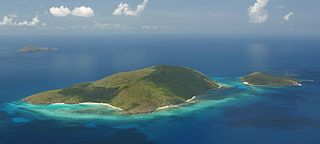
Buck Island Reef National Monument protects Buck Island, a small, uninhabited 176-acre island about 1.5 miles (2.4 km) north of the northeast coast of Saint Croix, U.S. Virgin Islands, and 18,839 acres of submerged lands, totaling 19,015 acres. It was first established as a protected area by the U.S. Government in 1948, with the intention of preserving “one of the finest marine gardens in the Caribbean Sea.” The U.S. National Monument was created in 1961 by John F. Kennedy and greatly expanded in 2001 by Bill Clinton, over the opposition of local fishermen. Buck Island National Monument is one of few places in the Virgin Islands where brown pelicans and threatened least terns nest.
Platte Island or Île Platte is an island in the Southern Coral Group that is part of the Outer Islands of the Seychelles.
Rose Atoll, sometimes called Rose Island or Motu O Manu by people of the Manu'a Islands, is an oceanic atoll within the U.S. territory of American Samoa. An uninhabited wildlife refuge, it is the southernmost point belonging to the United States, about 170 miles to the east of Tutuila, the principal island of American Samoa. The land area is just 0.05 km2 at high tide. The total area of the atoll, including lagoon and reef flat amounts to 6.33 km2. Just west of the northernmost point is a channel into the lagoon, about 80 metres (260 ft) wide. There are two islets on the northeastern rim of the reef, larger Rose Island, 3.5 metres (11 ft) high, in the east and the non-vegetated Sand Island, 1.5 metres (5 ft) high, in the north.

Marine National Park in the Gulf of Kutch is situated on the southern shore of the Gulf of Kutch in the Devbhumi Dwarka district of Gujarat state, India. In 1980, an area of 270 km2 from Okha to Jodiya was declared Marine Sanctuary. Later, in 1982, a core area of 110 km2 was declared Marine National Park under the provisions of the Wildlife (protection) Act, 1972 of India. There are 42 islands on the Jamnagar coast in the Marine National Park, most of them surrounded by reefs. The best-known island is Pirotan. The park protects two major ecosystems, corals and mangroves.

Ras Muhammad is a national park in Egypt at the southern extreme of the Sinai Peninsula, overlooking the Gulf of Suez on the west and the Gulf of Aqaba to the east. The park is becoming a center of eco-tourism in the region.

The Faial-Pico Channel is an 8.3 kilometres (5.2 mi) long channel that separates the islands of Faial and Pico in the central group of the archipelago of the Azores. The strait is divided into various depressions, calderas and micro-systems, referred to as Baixas.
The Hans Lollik Islands are two islands in the U.S. Virgin Islands owned by Larry Page. In 2014, Page bought Great Hans Lollik Island ("GHL") and its smaller neighbor, Little Hans Lollik, for $23 million.

The white-cheeked tern is a species of tern in the family Laridae. It is found around the coasts on the Red Sea, around the Horn of Africa to Kenya, in the Persian Gulf and along the Iranian coast to Pakistan and western India.

Washington Slagbaai National Park is a national park and ecological reserve on the northwestern part of the island of Bonaire in the Caribbean Netherlands. The 5,643 hectares (21.79 sq mi) park covering approximately a fifth of the island of Bonaire is managed by STINAPA Bonaire, a non-profit foundation, on behalf of the Bonaire government. Established in 1969, Washington Slagbaai National Park was the first nature reserve to be established in the former Netherlands Antilles.

Gladden Spit and Silk Cayes Marine Reserve (GSSCMR) is a protected marine reserve in the central part of Belize's Barrier Reef. It covers approximately 25,980 acres (10,510 ha) lying 36 kilometres (22 mi) off the coast of Placencia. Established in 2003, The reserve comes under the authority of the government's Fisheries Department, but is managed by the Southern Environmental Association, a community-based organisation.
Mnemba Island is a single small island located about 3 km off the northeast coast of Unguja, the largest island of the Zanzibar Archipelago, Tanzania, opposite Muyuni Beach. It is roughly triangular in shape, about 500 metres (1,640 ft) in diameter and about 1.5 kilometres (0.9 mi) in circumference. It is surrounded by an oval reef seven by four kilometres in extent. These reefs have been declared a marine conservation area. Mnemba Island and its reef are sometimes called Mnemba Atoll which is incorrect because an atoll is an island that encircles a lagoon, which is not the case for Mnemba Island.
Cape Byron Marine Park is one of four marine parks in New South Wales, Australia, and is the most recently sanctioned. The Cape Byron Marine Park is located in Northern NSW and extends 37 kilometres (23 mi) from the Brunswick River to Lennox Head. The marine park extends out to 3 nautical miles which dictates the border between state and federal jurisdiction. The marine park covers an area of 220 square kilometres (85 sq mi) and includes a variety of marine terrain including beaches, rocky shores, open ocean and the tidal waters of the Brunswick River and its tributaries, the Belongil Creek and Tallow Creek. The Cape Byron Marine Park was declared in 2002 and the zoning plan was implemented in April 2006. Of the 15 distinct marine ecosystems identified within the Tweed-Moreton bioregion, the Cape Byron Marine Park supports 10 of these.

The fauna of the United States Virgin Islands consists of 144 species of birds, 22 species of mammals, 302 species of fish and 7 species of amphibians. The animals include numerous native species of tropical birds, fish, and land reptiles as well as sea mammals. The only native land mammals are six species of native bats: the greater bulldog bat, Antillean fruit-eating bat, red fruit bat, Brazilian free-tailed bat, velvety free-tailed bat and the Jamaican fruit bat. Some of the nonnative land mammals roaming the islands are the white-tailed deer, small Asian mongoose, goats, feral donkeys, rats, mice, sheep, hogs, dogs and cats.

Solitary Islands Marine Park (SIMP) is a marine park in New South Wales State waters, Australia. It adjoins the Solitary Islands Marine Reserve and was declared under the Marine Parks Act 1997 (NSW) in January 1998. Prior to this it was declared a marine reserve in 1991. The Park was one of the first declared in NSW and stretches along the northern NSW coast, from Muttonbird Island, Coffs Harbour, to Plover Island near Sandon River, 75 kilometres to the north. It includes coastal estuaries and lakes and extends from the mean high water mark, to three nautical miles out to sea, covering an area of around 72,000 hectares. There are five main islands in the Park, North Solitary Island, North West Solitary Island, South West Solitary Island, South Solitary Island and Split Solitary Island, as well as other significant outcrops such as Muttonbird Island and submerged reefs.
Qatar is a peninsula on the northeastern coast of the Arabian Peninsula, facing mainland Saudi Arabia to the south and surrounded elsewhere by the Persian Gulf. A strait separates Qatar from the island kingdom of Bahrain.
Alibijaban is a small island located off the southeastern coast of Bondoc Peninsula in the island of Luzon. It belongs administratively to the municipality of San Andres, Quezon province, and is coterminous with the barangay of the same name. With a population of 1,738 inhabitants in 2020, it is the smallest of seven barangays in San Andres.
The wildlife of Bahrain is the flora and fauna of the archipelago of Bahrain. Apart from a strip of the north and west of the main island, where crops such as potatoes are grown with irrigation, the land is arid. With a very hot dry summer, a mild winter, and brackish groundwater, the plants need adaptations in order to survive. Nevertheless, 196 species of higher plant have been recorded here, as well as about seventeen species of terrestrial mammals, many birds and reptiles, and many migratory birds visit the islands in autumn and spring.
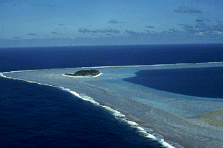
The Coral Sea Marine Park is an Australian marine park located in the Coral Sea off the coast of Queensland. The marine park covers an area of 989,836 km2 (382,178 sq mi) and is assigned IUCN category IV. It is Australia's largest single marine park and together with the French Natural Park of the Coral Sea form the largest protected area in the World.


 .
. .
. .
.


