
Clayoquot Sound is located on the west coast of Vancouver Island in the Canadian province of British Columbia. It is bordered by the Esowista Peninsula to the south, and the Hesquiaht Peninsula to the North. It is a body of water with many inlets and islands. Major inlets include Sydney Inlet, Shelter Inlet, Herbert Inlet, Bedwell Inlet, Lemmens Inlet, and Tofino Inlet. Major islands include Flores Island, Vargas Island, and Meares Island. The name is also used for the larger region of land around the waterbody.

Port Alberni is a city located on Vancouver Island in the province of British Columbia, Canada.
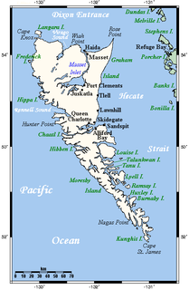
Graham Island is the largest island in the Haida Gwaii archipelago, lying off the coast of British Columbia, Canada. It is separated only by a narrow channel from the other principal island of the group, Moresby Island. It has a population of 4,475, an area of 6,361 km2 (2,456 sq mi), and is the 101st largest island in the world and Canada's 22nd largest island.

Ucluelet is a district municipality on the Ucluelet Peninsula on the west coast of Vancouver Island in British Columbia, Canada. Ucluelet means "people of the safe harbour" in the indigenous Nuu-chah-nulth (Nootka) language. As of 2016, its population was 1,717, a 5.5% increase from 1,627 in 2011.

Rivers Inlet is a fjord in the Central Coast region of the Canadian province of British Columbia, its entrance off Fitz Hugh Sound, about 125 km (78 mi) southwest of the community of Bella Coola and about 65 km (40 mi) north of the northern tip of Vancouver Island and the western entrance of the Queen Charlotte Strait.
The District Municipality of Sechelt is located on the lower Sunshine Coast of British Columbia. Approximately 50 km northwest of Vancouver, it is accessible from mainland British Columbia by a 40-minute ferry trip between Horseshoe Bay and Langdale, and a 25-minute drive from Langdale along Highway 101, also known as the Sunshine Coast Highway. The name Sechelt is derived from the Sechelt language word, shishalh, the name of the First Nations people who first settled the area thousands of years ago.
Texada Island is a large island located in the Strait of Georgia of British Columbia, Canada. With an area of 300.45 km2 (116.00 sq mi), it is the largest island of the Gulf Islands and the third largest island in the Salish Sea after Quadra Island of the Discovery Islands and Whidbey Island in Washington.

Jervis Inlet is one of the principal inlets of the British Columbia Coast, about 95 km (59 mi) northwest of Vancouver, and the third of such inlets north of the 49th parallel, the first of which is Burrard Inlet, Vancouver's harbour.
Butedale is a ghost town on Princess Royal Island, in British Columbia, Canada. It was founded in 1918 as a fishing, mining and logging camp. Initially the salmon cannery was established by Western Packers which was purchased and operated by the Canadian Fishing Company until it ceased operating in the 1950s. At its peak the summertime population of Butedale was over 400 people.

Zeballos is a village located on the northwest coast of Vancouver Island in British Columbia, Canada. While legend suggests Spanish gold seekers may have explored the area in the late 16th century, Zeballos is now known for its ecotourism and sport fishing.
Port Clements is an incorporated village situated at the east end of Masset Inlet in Haida Gwaii off the coast of the Province of British Columbia in Canada. Known as Gamadiis in HlG̱aagilda X̱aayda kil, it is one of seven village sites that flourished in the rich waters at the mouth of Yakoun River, where an estuary shelters nine Pacific salmonid species and many kinds of birds. Founded by Eli Tingley in 1907, it was once known under the name Queenstown, but renamed to Port Clements in 1914 after Herb S. Clements, the local MP at the time, when the name "Queenstown" duplicated and therefore became unusable for the post office.

The Village of Queen Charlotte, more commonly known by its residents as Charlotte, is a village municipality on Haida Gwaii in the province of British Columbia, Canada. It is located on the southern end of Graham Island at Skidegate Inlet and is a member municipality of the North Coast Regional District.

Princess Louisa Inlet on the British Columbia Coast is 6 km (3.7 mi) in length and lies at the north east end of Jervis Inlet. It is entered through Malibu Rapids off Queens Reach past Malibu, a former private resort and now youth camp. A portion of the area makes up Princess Louisa Marine Provincial Park. James Bruce Falls and Chatterbox Falls are on Loquilts Creek, a large stream that enters the head of the inlet.

West Thurlow Island is an island in British Columbia, Canada. It is part of the Discovery Islands, an archipelago between Vancouver Island and the mainland, whose waters connect the Strait of Georgia with Johnstone Strait and Queen Charlotte Strait.

Skidegate Channel is a strait located in the Haida Gwaii archipelago of British Columbia, Canada. It divides the archipelago's two main islands, Graham Island to the north and Moresby Island to the south.

Louise Island is a 275-square-kilometre (106 sq mi) island in Haida Gwaii, in British Columbia, Canada, off the east coast of Moresby Island. It was named for Princess Louise, Duchess of Argyll, fourth daughter of Queen Victoria. Louise Island is located east of Moresby Island and Carmichael Passage, and south of Cumshewa Inlet.
Sewall, sometimes incorrectly spelled Sewell, is an unincorporated locality located on the north shore of Masset Inlet, on Graham Island in the Haida Gwaii archipelago off the North Coast of British Columbia, Canada. It is located 21 miles up Masset Inlet.

Cuneah, also Gunia, Cunneah, Cunnyha, Cunniah, Coneehaw, Connehaw, Cunneaw (Haida: Gəniyá, was the chief of Kiusta, a town at the northwestern tip of Graham Island during the era of the Maritime Fur Trade in Haida Gwaii off the North Coast of British Columbia, Canada. This town was an important port of call for acquiring sea otter skins in the early years of the maritime fur trade. Cuneah seems to have avoided the violence that plagued other Haida chiefs, like Koyah.

Checleset Bay is a bay on the northwest coast of Vancouver Island, British Columbia, Canada. It is located southeast of Brooks Peninsula and northwest of Kyuquot Sound. Much of the land around the bay is part of Brooks Peninsula Provincial Park. Checleset Bay has three large inlets, Nasparti Inlet, Ououkinsh Inlet, and Malksope Inlet.

