U.S. Route 56 is an east–west United States highway that runs for 640 miles (1,030 km) in the Midwestern United States. The highway's eastern terminus is at U.S. Route 71 in Kansas City, Missouri. Its western terminus is at Interstate 25 Business in Springer, New Mexico. Much of it follows the Santa Fe Trail.

State Highway 99, abbreviated SH-99, is a north–south state highway through central Oklahoma. It runs from the Texas border at Lake Texoma to the Kansas border near Lake Hulah. It is 241.5 miles (388.7 km) long. The highway overlaps US-377 for over half its length.

K-26 is a 3.601-mile-long (5.795 km) state highway located entirely within Cherokee County, Kansas. It runs from an intersection with U.S. Route 166 (US-166) and US-400 northwest of the Missouri/Kansas/Oklahoma tripoint north to K-66 in Galena. The highway is maintained by the Kansas Department of Transportation (KDOT).

State Highway 8, also abbreviated as SH-8 or OK-8, is a highway maintained by the U.S. state of Oklahoma. Because it runs mainly north–south, it has an even number. Highway 8 runs from U.S. Highway 277 in Cyril, Oklahoma to the state line south of Kiowa, Kansas, for a total length of 179.1 miles (288.2 km) The highway has two lettered spur routes.

State Highway 108 is a minor state highway in Payne, Noble, and Pawnee counties in north-central Oklahoma. It runs for 24.1 miles (38.8 km), from SH-33 south of Ripley to U.S. Route 64 (US-64) in Lela. SH-108 has no lettered spurs.

State Highway 23 is a state highway in Oklahoma. It runs 36.2 miles south-to-north through the center of Beaver County, in the Panhandle, running from the Texas state line to the Kansas state line.

State Highway 58 is the name of two state highways in Oklahoma. One of them runs for 72.7 miles (117.0 km) from Medicine Park to the Blaine–Custer County line near Hydro, and the other connects US-270/281/SH-3/33 to the Kansas state line, a length of 105.9 mi (170.4 km). The northern section has one lettered spur route, SH-58A.
K-8 is the name of two separate state highways in Kansas, United States. The southern highway is a 1.3-mile-long (2.1 km) road, linking Oklahoma State Highway 8 (SH-8) to the town of Kiowa. The northern highway links U.S. Route 36 (US-36) near Athol to Nebraska Highway 10 (N-10) near the town of Franklin.
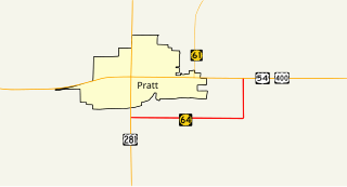
K-64 was a 3.574-mile-long (5.752 km) state highway in Pratt County, Kansas. The highway was a partial bypass of Pratt that ran from U.S. Route 281 (US-281) just south of the city limits to US-54/US-400 east of them. The route was maintained by the Kansas Department of Transportation until July 10, 2015 when the road was turned over to Pratt County. K-64 was not part of the National Highway System. K-64 was designated at around 1932 and paved in 1937.

K-3 is a 43.262-mile-long (69.623 km) state highway in southeastern Kansas that runs through Crawford, Bourbon and Linn counties from K-47 near Girard to K-31 near Blue Mound. It was designated around 1932, and the entire route was paved by 1958. The road is maintained by the Kansas Department of Transportation (KDOT), and is a two-lane road for its entire length. The route's concurrency with U.S. Route 54 (US-54) is a part of the National Highway System.

State Highway 95 is a state highway in the Panhandle region of the U.S. state of Oklahoma. This route, which is 42.1 miles (67.8 km) long, runs entirely through western Texas County. SH-95 does not have any lettered spur routes.
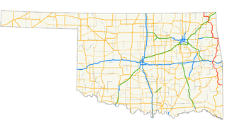
U.S. Highway 59 (US-59) heads along the eastern portion of the state of Oklahoma. US-59's 216.47-mile (348.37 km) route through Oklahoma takes it through the mountainous terrain of the eastern Oklahoma Ouachitas and Ozarks. US-59 serves several lakes and towns through Oklahoma's Green Country, including Grand Lake, a major recreation center. The route enters the state from Arkansas near Fogel, Arkansas, and ends at the Kansas state line south of Chetopa, Kansas.

K-17 was a 21.138-mile-long (34.018 km) state highway in Kansas that served Kingman and Reno counties. The route originated at an intersection with U.S. Route 54 (US-54) and US-400 south of the unincorporated community of Waterloo and ended at K-96 south of South Hutchinson. The road was maintained by the Kansas Department of Transportation (KDOT), and was a two-lane road for its entire length. The entirety of this portion of the route is now designated as a part of K-14.

K-43 is a 20.718-mile-long (33.342 km) state highway in the U.S. state of Kansas. The highway runs from K-4 in Hope north to Interstate 70 (I-70) and U.S. Route 40 (US-40) north of Detroit. The entire highway is located within Dickinson County. K-43 is maintained by the Kansas Department of Transportation (KDOT), and is a relatively minor highway. K-43 is not part of the National Highway System. The highway was established around 1932, with the northern terminus being the now decommissioned US-40S. In 1962, the route was extended north a bit to a new diamond interchange with I-70.

K-22 is a 3-mile-long (4.8 km) highway in the U.S. state of Kansas. Located entirely within Washington County, the route runs from U.S. Route 36 (US-36) north to the city limit of Haddam. A previous designation of the route existed in the 1930s from Wichita to Topeka, but was deprecated. The current alignment was designated in the 1940s.

K-60 is a 4.284-mile-long (6.894 km) state highway in the U.S. state of Kansas. It runs from U.S. Route 36 north to K-383 near Almena. The route was established around 1930.
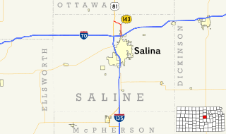
K-143 is a state highway in Saline County, Kansas. The route runs 4.658 miles (7.496 km) in a general north-south direction through lands mostly used for agriculture from an interchange at Interstate 70 (I-70) in northern Salina, Kansas to a junction with U.S. Route 81 (US-81). The southern part of the route is a four-lane divided highway while the rest is a two-lane highway. It has an annual average daily traffic (AADT) between 1,580 and 4,133 vehicles. The route is paved with three different pavement types, and is not a part of the National Highway System. It was first designated as US-81 Alternate in the early 1970s with the designation being changed to K-143 in the early 1980s.

K-146 is a state highway in eastern Kansas that runs 15.564 miles (25.048 km) from U.S. Route 59 (US-59) in Neosho County to K-3 in Crawford County. The main purpose of the route is to serve the small community of Walnut. The highway is two lanes for its entire length, and no part of it is included in the National Highway System.
