Anthony, Kansas

Last updated

Anthony, Kansas
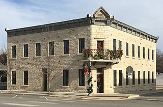
Harper County Courthouse.png
Harper County Courthouse (2015)
Harper County Kansas Incorporated and Unincorporated areas Anthony Highlighted.svg
Location within Harper County and Kansas
Map of Harper Co, Ks, USA.png
Coordinates: 37°09′32″N98°02′31″W / 37.15889°N 98.04194°W / 37.15889; -98.04194 [1]
Country United States
State Kansas
County Harper
Founded1870s
Platted 1878
Incorporated 1879
Named for George Anthony
Area
[2]
  Total3.21 sq mi (8.31 km2)
  Land3.03 sq mi (7.85 km2)
  Water0.18 sq mi (0.46 km2)
Elevation
[1]
1,352 ft (412 m)
Population
 (2020) [3]
  Total2,108
  Density660/sq mi (250/km2)
Time zone UTC-6 (CST)
  Summer (DST) UTC-5 (CDT)
ZIP code
67003
Area code 620
FIPS code 20-01975
GNIS ID 485540 [1]
Website anthonykansas.org

Anthony is a city in and the county seat of Harper County, Kansas, United States. [1] As of the 2020 census, the population of the city was 2,108. [3]

Contents

History

The Anthony townsite was laid out in 1878. [4] The city was named after the 7th governor of Kansas, George T. Anthony who was in office at the time. [5] Following the reorganization of Harper County in 1878 following the original fraudulent organization in 1873, Anthony was designated the temporary county seat, as Bluff City, designated county seat of the fraudulent county organization, did not exist at the time. In 1879, a county seat election was held, and Anthony won over Harper City even though 2,960 ballots were cast with 800 legal voters in the county. [6]

Anthony existed at the intersection of the St. Louis-San Francisco Railroad and the Missouri Pacific Railway since at least 1891. [7] Three additional railroads came through town by 1912: the Choctaw Northern Railroad (by then owned by the Chicago, Rock Island and Pacific Railroad), the Kansas City, Mexico and Orient Railroad and the Kansas Southwestern Railway (the latter two becoming part of the Atchison, Topeka and Santa Fe Railway. [7] [8] However, rail abandonments began around 1986, leaving Anthony without any rail service by 2000. [7] [9]

Geography

According to the United States Census Bureau, the city has a total area of 3.31 square miles (8.57 km2), of which, 3.13 square miles (8.11 km2) is land and 0.18 square miles (0.47 km2) is water. [10]

Climate

The climate in this area is characterized by hot, humid summers and generally mild to cool winters. According to the Köppen Climate Classification system, Anthony has a humid subtropical climate, abbreviated "Cfa" on climate maps. [11]

Climate data for Anthony, Kansas, 1991–2020 normals, extremes 1906–present
MonthJanFebMarAprMayJunJulAugSepOctNovDecYear
Record high °F (°C)80
(27)
90
(32)
98
(37)
99
(37)
106
(41)
113
(45)
115
(46)
115
(46)
111
(44)
100
(38)
88
(31)
85
(29)
115
(46)
Mean maximum °F (°C)67.4
(19.7)
72.8
(22.7)
80.9
(27.2)
86.6
(30.3)
92.9
(33.8)
98.7
(37.1)
103.1
(39.5)
102.1
(38.9)
97.5
(36.4)
89.2
(31.8)
76.8
(24.9)
66.7
(19.3)
104.4
(40.2)
Mean daily maximum °F (°C)44.7
(7.1)
49.2
(9.6)
59.1
(15.1)
68.3
(20.2)
77.5
(25.3)
88.0
(31.1)
92.9
(33.8)
90.9
(32.7)
83.3
(28.5)
70.7
(21.5)
57.4
(14.1)
46.0
(7.8)
69.0
(20.6)
Daily mean °F (°C)33.6
(0.9)
37.4
(3.0)
46.8
(8.2)
55.9
(13.3)
66.4
(19.1)
76.6
(24.8)
81.4
(27.4)
79.5
(26.4)
71.6
(22.0)
58.8
(14.9)
45.8
(7.7)
35.6
(2.0)
57.5
(14.1)
Mean daily minimum °F (°C)22.4
(−5.3)
25.6
(−3.6)
34.5
(1.4)
43.6
(6.4)
55.2
(12.9)
65.1
(18.4)
69.9
(21.1)
68.0
(20.0)
59.8
(15.4)
46.9
(8.3)
34.3
(1.3)
25.2
(−3.8)
45.9
(7.7)
Mean minimum °F (°C)7.5
(−13.6)
10.4
(−12.0)
17.8
(−7.9)
29.6
(−1.3)
41.9
(5.5)
54.7
(12.6)
61.8
(16.6)
59.7
(15.4)
46.1
(7.8)
31.1
(−0.5)
19.0
(−7.2)
10.4
(−12.0)
3.2
(−16.0)
Record low °F (°C)−15
(−26)
−20
(−29)
−3
(−19)
13
(−11)
26
(−3)
43
(6)
49
(9)
43
(6)
30
(−1)
12
(−11)
7
(−14)
−15
(−26)
−20
(−29)
Average precipitation inches (mm)1.00
(25)
1.23
(31)
2.47
(63)
3.28
(83)
4.79
(122)
4.96
(126)
3.68
(93)
3.23
(82)
2.56
(65)
2.89
(73)
1.63
(41)
1.42
(36)
33.14
(840)
Average snowfall inches (cm)2.4
(6.1)
2.8
(7.1)
2.1
(5.3)
0.1
(0.25)
0.0
(0.0)
0.0
(0.0)
0.0
(0.0)
0.0
(0.0)
0.0
(0.0)
0.1
(0.25)
0.5
(1.3)
3.1
(7.9)
11.1
(28.2)
Average precipitation days (≥ 0.01 in)3.74.86.87.39.78.87.67.75.76.34.65.078.0
Average snowy days (≥ 0.1 in)1.61.60.80.10.00.00.00.00.00.10.41.76.3
Source 1: NOAA [12]
Source 2: National Weather Service [13]

Demographics

Historical population
CensusPop.Note
1880 345
1890 1,806423.5%
1900 1,179−34.7%
1910 2,669126.4%
1920 2,7402.7%
1930 2,9477.6%
1940 2,873−2.5%
1950 2,792−2.8%
1960 2,744−1.7%
1970 2,653−3.3%
1980 2,6610.3%
1990 2,516−5.4%
2000 2,440−3.0%
2010 2,269−7.0%
2020 2,108−7.1%
U.S. Decennial Census

2020 census

The 2020 United States census counted 2,108 people, 922 households, and 538 families in Anthony. [14] [15] The population density was 654.3 per square mile (252.6/km2). There were 1,217 housing units at an average density of 377.7 per square mile (145.8/km2). [15] [16] The racial makeup was 90.28% (1,903) white or European American (87.62% non-Hispanic white), 0.62% (13) black or African-American, 2.09% (44) Native American or Alaska Native, 0.43% (9) Asian, 0.09% (2) Pacific Islander or Native Hawaiian, 0.95% (20) from other races, and 5.55% (117) from two or more races. [17] Hispanic or Latino of any race was 5.22% (110) of the population. [18]

Of the 922 households, 25.9% had children under the age of 18; 41.1% were married couples living together; 30.7% had a female householder with no spouse or partner present. 36.3% of households consisted of individuals and 17.7% had someone living alone who was 65 years of age or older. [15] The average household size was 2.5 and the average family size was 3.1. [19] The percent of those with a bachelor’s degree or higher was estimated to be 11.7% of the population. [20]

22.9% of the population was under the age of 18, 7.4% from 18 to 24, 22.6% from 25 to 44, 24.3% from 45 to 64, and 22.8% who were 65 years of age or older. The median age was 41.7 years. For every 100 females, there were 105.5 males. [15] For every 100 females ages 18 and older, there were 109.1 males. [15]

The 2016-2020 5-year American Community Survey estimates show that the median household income was $51,023 (with a margin of error of +/- $7,977) and the median family income was $54,779 (+/- $12,527). [21] Males had a median income of $36,636 (+/- $3,235) versus $23,951 (+/- $2,661) for females. The median income for those above 16 years old was $31,958 (+/- $4,258). [22] Approximately, 12.4% of families and 15.4% of the population were below the poverty line, including 17.9% of those under the age of 18 and 15.9% of those ages 65 or over. [23] [24]

2010 census

As of the census [25] of 2010, there were 2,269 people, 977 households, and 631 families residing in the city. The population density was 724.9 inhabitants per square mile (279.9/km2). There were 1,217 housing units at an average density of 388.8 per square mile (150.1/km2). The racial makeup of the city was 94.0% White, 0.5% African American, 1.3% Native American, 0.2% Asian, 0.3% Pacific Islander, 1.5% from other races, and 2.2% from two or more races. Hispanic or Latino of any race were 4.0% of the population.

There were 977 households, of which 28.5% had children under the age of 18 living with them, 48.0% were married couples living together, 12.1% had a female householder with no husband present, 4.5% had a male householder with no wife present, and 35.4% were non-families. 31.7% of all households were made up of individuals, and 16.6% had someone living alone who was 65 years of age or older. The average household size was 2.26 and the average family size was 2.79.

The median age in the city was 43.1 years. 23.8% of residents were under the age of 18; 6.1% were between the ages of 18 and 24; 22% were from 25 to 44; 25.5% were from 45 to 64; and 22.5% were 65 years of age or older. The gender makeup of the city was 48.1% male and 51.9% female.

2000 census

As of the census [26] of 2000, there were 2,440 people, 1,059 households, and 659 families residing in the city. The population density was 1,597.4 inhabitants per square mile (616.8/km2). There were 1,215 housing units at an average density of 795.4 per square mile (307.1/km2). The racial makeup of the city was 96.19% White, 0.29% African American, 0.98% Native American, 0.20% Asian, 0.53% from other races, and 1.80% from two or more races. Hispanic or Latino of any race were 1.48% of the population.

There were 1,059 households, out of which 28.7% had children under the age of 18 living with them, 51.0% were married couples living together, 7.7% had a female householder with no husband present, and 37.7% were non-families. 34.8% of all households were made up of individuals, and 21.5% had someone living alone who was 65 years of age or older. The average household size was 2.25 and the average family size was 2.91.

In the city, the population was spread out, with 25.8% under the age of 18, 7.5% from 18 to 24, 21.9% from 25 to 44, 20.7% from 45 to 64, and 24.1% who were 65 years of age or older. The median age was 41 years. For every 100 females, there were 90.9 males. For every 100 females age 18 and over, there were 84.3 males.

The median income for a household in the city was $24,730, and the median income for a family was $37,321. Males had a median income of $27,042 versus $17,604 for females. The per capita income for the city was $14,540. About 12.8% of families and 16.4% of the population were below the poverty line, including 24.8% of those under age 18 and 8.4% of those age 65 or over.

Education

The community is served by Chaparral USD 361 public school district. [27] USD 361 was created through school unification that consolidated Anthony and Harper schools.

Both Anthony and Harper have elementary schools. The district high school, Chaparral High School, is located halfway between the two towns. The Chaparral High School mascot is Roadrunners. [28]

Anthony High School was closed through school unification. The Anthony High School mascot was Pirates. [29]

Notable people

Related Research Articles

<span class="mw-page-title-main">Everest, Kansas</span> City in Brown County, Kansas

Everest is a city in Brown County, Kansas, United States. As of the 2020 census, the population of the city was 265.

<span class="mw-page-title-main">Augusta, Kansas</span> City in Butler County, Kansas

Augusta is a city in Butler County, Kansas, United States. As of the 2020 census, the population of the city was 9,256.

<span class="mw-page-title-main">Aurora, Kansas</span> City in Cloud County, Kansas

Aurora is a city in Cloud County, Kansas, United States. As of the 2020 census, the population of the city was 56.

<span class="mw-page-title-main">Cambridge, Kansas</span> City in Cowley County, Kansas

Cambridge is a city in Cowley County, Kansas, United States. As of the 2020 census, the population of the city was 92.

<span class="mw-page-title-main">Cherokee, Kansas</span> City in Crawford County, Kansas

Cherokee is a city in Crawford County, Kansas, United States. As of the 2020 census, the population of the city was 590.

<span class="mw-page-title-main">Baldwin City, Kansas</span> City in Kansas, United States

Baldwin City is a city in Douglas County, Kansas, United States, about 12 miles (19 km) south of Lawrence. As of the 2020 census, the population of the city was 4,826. The city is home to Baker University, the state's oldest four-year university.

<span class="mw-page-title-main">Altamont, Kansas</span> City in Labette County, Kansas

Altamont is a city in Labette County, Kansas, United States. As of the 2020 census, the population of the city was 1,061.

<span class="mw-page-title-main">Barnard, Kansas</span> City in Lincoln County, Kansas

Barnard is a city in Lincoln County, Kansas, United States. As of the 2020 census, the population of the city was 64.

<span class="mw-page-title-main">Admire, Kansas</span> City in Lyon County, Kansas

Admire is a city in Lyon County, Kansas, United States. As of the 2020 census, the population of the city was 130.

<span class="mw-page-title-main">Allen, Kansas</span> City in Lyon County, Kansas

Allen is a city in Lyon County, Kansas, United States. As of the 2020 census, the population of the city was 160.

<span class="mw-page-title-main">Americus, Kansas</span> City in Lyon County, Kansas

Americus is a city in Lyon County, Kansas, United States. As of the 2020 census, the population of the city was 776. It is located northwest of the city of Emporia. Americus is often a waypoint in some Unbound Gravel bike races.

<span class="mw-page-title-main">Axtell, Kansas</span> City in Marshall County, Kansas

Axtell is a city in Marshall County, Kansas, United States. As of the 2020 census, the population of the city was 399.

<span class="mw-page-title-main">Cherryvale, Kansas</span> City in Montgomery County, Kansas

Cherryvale is a city in Montgomery County, Kansas, United States. As of the 2020 census, the population of the city was 2,192.

<span class="mw-page-title-main">Agra, Kansas</span> City in Phillips County, Kansas

Agra is a city in Phillips County, Kansas, United States. As of the 2020 census, the population of the city was 208.

<span class="mw-page-title-main">Arlington, Kansas</span> City in Reno County, Kansas

Arlington is a city in Reno County, Kansas, United States. As of the 2020 census, the population of the city was 435.

<span class="mw-page-title-main">Alden, Kansas</span> City in Rice County, Kansas

Alden is a city in Rice County, Kansas, United States. As of the 2020 census, the population of the city was 122.

<span class="mw-page-title-main">Assaria, Kansas</span> City in Saline County, Kansas

Assaria is a city in Saline County, Kansas, United States. As of the 2020 census, the population of the city was 428.
<span class="mw-page-title-main">Andale, Kansas</span> City in Sedgwick County, Kansas

Andale is a city in Sedgwick County, Kansas, United States. As of the 2020 census, the population of the city was 941.

<span class="mw-page-title-main">Alma, Kansas</span> City in Wabaunsee County, Kansas

Alma is a city in and the county seat of Wabaunsee County, Kansas, United States. As of the 2020 census, the population of the city was 802.

<span class="mw-page-title-main">Alta Vista, Kansas</span> City in Wabaunsee County, Kansas

Alta Vista is a city in Wabaunsee County, Kansas, United States. As of the 2020 census, the population of the city was 409.

References

  1. 1 2 3 4 U.S. Geological Survey Geographic Names Information System: Anthony, Kansas
  2. "2019 U.S. Gazetteer Files". United States Census Bureau. Retrieved July 24, 2020.
  3. 1 2 "Profile of Anthony, Kansas in 2020". United States Census Bureau. Archived from the original on March 24, 2022. Retrieved March 24, 2022.
  4. History of the State of Kansas: Containing a Full Account of Its Growth from an Uninhabited Territory to a Wealthy and Important State. A. T. Andreas. 1883. p. 365.
  5. Blackmar, Frank Wilson (1912). Kansas: A Cyclopedia of State History, Embracing Events, Institutions, Industries, Counties, Cities, Towns, Prominent Persons, Etc. Standard Publishing Company. p. 78. ISBN   9780722249055.
  6. Cutler, William G. (1883). History of the State of Kansas. A.T. Andreas. Archived from the original on February 17, 2003.
  7. 1 2 3 "Anthony, Kansas: The Town Forgotten By The Railroads". Forgotten Railways, Roads & Places, September 7, 2018. Retrieved March 11, 2023.
  8. "Choctaw Northern Railroad Company". Railroads of Oklahoma, June 6, 1870-April 1, 1978 (accessed on Oklahoma Digital Prairie), pp. 42-44. Retrieved March 11, 2023.
  9. "Kansas Railroad Map 2022" (PDF). Kansas Department of Transportation. Retrieved March 13, 2023.
  10. "US Gazetteer files 2010". United States Census Bureau. Archived from the original on January 25, 2012. Retrieved July 6, 2012.
  11. Climate Summary for Anthony, Kansas
  12. "U.S. Climate Normals Quick Access – Station: Anthony, KS". National Oceanic and Atmospheric Administration. Retrieved November 26, 2023.
  13. "NOAA Online Weather Data – NWS Wichita". National Weather Service. Retrieved November 26, 2023.
  14. "US Census Bureau, Table P16: HOUSEHOLD TYPE". data.census.gov. Retrieved December 31, 2023.
  15. 1 2 3 4 5 "US Census Bureau, Table DP1: PROFILE OF GENERAL POPULATION AND HOUSING CHARACTERISTICS". data.census.gov. Retrieved December 31, 2023.
  16. Bureau, US Census. "Gazetteer Files". Census.gov. Retrieved December 30, 2023.
  17. "US Census Bureau, Table P1: RACE". data.census.gov. Retrieved December 31, 2023.
  18. "US Census Bureau, Table P2: HISPANIC OR LATINO, AND NOT HISPANIC OR LATINO BY RACE". data.census.gov. Retrieved December 31, 2023.
  19. "US Census Bureau, Table S1101: HOUSEHOLDS AND FAMILIES". data.census.gov. Retrieved December 31, 2023.
  20. "US Census Bureau, Table S1501: EDUCATIONAL ATTAINMENT". data.census.gov. Retrieved December 31, 2023.
  21. "US Census Bureau, Table S1903: MEDIAN INCOME IN THE PAST 12 MONTHS (IN 2020 INFLATION-ADJUSTED DOLLARS)". data.census.gov. Retrieved December 31, 2023.
  22. "US Census Bureau, Table S2001: EARNINGS IN THE PAST 12 MONTHS (IN 2020 INFLATION-ADJUSTED DOLLARS)". data.census.gov. Retrieved December 31, 2023.
  23. "US Census Bureau, Table S1701: POVERTY STATUS IN THE PAST 12 MONTHS". data.census.gov. Retrieved December 31, 2023.
  24. "US Census Bureau, Table S1702: POVERTY STATUS IN THE PAST 12 MONTHS OF FAMILIES". data.census.gov. Retrieved December 31, 2023.
  25. "U.S. Census website". United States Census Bureau . Retrieved July 6, 2012.
  26. "U.S. Census website". United States Census Bureau . Retrieved January 31, 2008.
  27. "Anthony-Harper". USD 361. Retrieved January 7, 2017.
  28. "Anthony-Harper". USD 361. Retrieved January 4, 2017.
  29. "Anthony Into First With Win", The Hutchinson News, 13 January 1945, p.2.
  30. Dennis Moore, Biographical Directory of the United States Congress . Retrieved 23 August 2016.
  31. Virgil Richard-obituary

Further reading