
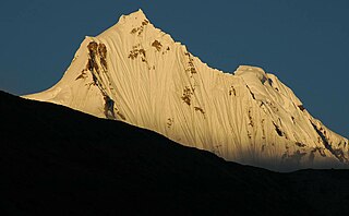
Sikkim is a state in Northeastern India. It borders the Tibet Autonomous Region of China in the north and northeast, Bhutan in the east, Province No. 1 of Nepal in the west and West Bengal in the south. Sikkim is also close to the Siliguri Corridor, which borders Bangladesh. Sikkim is the least populous and second smallest among the Indian states. Situated in the Eastern Himalaya, Sikkim is notable for its biodiversity, including alpine and subtropical climates, as well as being a host to Kangchenjunga, the highest peak in India and third highest on Earth. Sikkim's capital and largest city is Gangtok. Almost 35% of the state is covered by Khangchendzonga National Park – a UNESCO World Heritage Site.
Sikkim National Party was a political party in the Kingdom of Sikkim, formed in 1950. The Sikkim National Party was in favour of the monarchy and advocated independence for Sikkim. The party was founded to counter the growing influence of the pro-Indian parties Sikkim State Congress and Rajya Praja Sammelan, that had been formed after the independence of India in 1947.

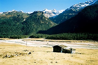
West Sikkim is a district of the Indian state of Sikkim. Its headquarter is Geyzing, also known as Gyalshing. The district is a favourite with trekkers due to the high elevations. Other important towns include Pelling and Yuksom. Local people also call it as Pallo-Sikkim and Sano-Sikkim commonly.
North Sikkim is a district of the Indian state of Sikkim. Its district headquarters is Mangan. It is the seventh least populous district in the country.

Namchi District is a district of the Indian state of Sikkim. Its headquarters is at Namchi.

Bagdogra is a settlement in the Naxalbari CD block in the Siliguri subdivision of the Darjeeling district, in the Indian state of West Bengal. It is a part of the Greater Siliguri Metropolitan Area. The Bagdogra is well connected by air to six major cities of India – Delhi, Mumbai, Bengaluru, Hyderabad, Kolkata and Chennai through the Bagdogra Airport. The Bagdogra railway station is also well connected.
Kabi or KABI may refer to:
The indigenous people of Sikkim are the Lepchas; the naturalized ethnic populations of Limbus, Bhutias, Kiratis, Indian Gorkhas or Indian Nepali/Nepalese who have an enduring presence in shaping the history of modern Sikkim.

Kabi Lungchok is a historic site of significance, which is located 17 kilometres (11 mi) north of Gangtok on the Northern Highway in northeastern Indian state of Sikkim. The historicity of the site is attributed to the fact that the Lepchas, the ethnic tribals of Sikkim and Bhutias, the immigrants from southern Bhot who settled down in Sikkim from the 14th century onwards, ceremonially signed a "Treaty of Blood Brotherhood" with religious fervour. Stone pillars mark the location where the treaty was signed. The Treaty was signed at Kabi Lungchok by the Bhot King, Khye Bumsa representing the Bhutias and the Lepcha Chief Thekong Tek. The literal meaning of 'Kabi Lungchok', pronounced ‘Kayu sha bhi Lungchok’, is "stone erected by our blood." Life-size statues of the Lepcha and Bhutia 'blood-brothers' who signed the treaty has been erected here.
Murarai is a census town in Murarai I CD block in Rampurhat subdivision of Birbhum district in the Indian state of West Bengal.
Tung is a village in the Chungthang subdivision of North Sikkim district in the north Indian state of Sikkim. The Ministry of Home Affairs has given it a geographical code of 260863.

Chungthang subdivision is one of the two sub-districts of North Sikkim district, in the state of Sikkim, India. Chungthang is the headquarters. It contains nine census-designated villages:
Mangan subdivision is one of the two sub-districts of North Sikkim district, in the state of Sikkim, India. Mangan is the headquarters. It contains 46 census-designated villages:
Salim Pakel is a village in Mangan subdivision, North Sikkim district, Sikkim, India. The Ministry of Home Affairs has given it a geographical code of 260874.
Lingthem is a village in Mangan subdivision, North Sikkim district, Sikkim, India. The Ministry of Home Affairs has given it a geographical code of 260875.
Lingdem is a village in Mangan subdivision, North Sikkim district, Sikkim, India. The Ministry of Home Affairs has given it a geographical code of 260876.
Chawang is a village in Mangan subdivision, North Sikkim district, Sikkim, India. The Ministry of Home Affairs has given it a geographical code of 260901.
Kabi Forest Block is a village in Mangan subdivision, North Sikkim district, Sikkim, India. The Ministry of Home Affairs has given it a geographical code of 260913.

The following outline is provided as an overview of and topical guide to Sikkim:
Kabi Lungchok Assembly constituency is one of the 32 assembly constituencies of Sikkim, It lies on East Sikkim district and North Sikkim district. This constituency falls under Sikkim Lok Sabha constituency.

