
Palamu district is one of the twenty-four districts of Jharkhand, India. It was formed in 1892. The administrative headquarters of the district is Medininagar, situated on the Koel River. Palamu district lies in north-western part of Jharkhand. It shares border with Chatra, Garhwa & Latehar Districts of Jharkhand state and Aurangabad, Gaya & Rohtas Districts of Bihar state.
Hoshiarpur district is a district of Punjab state in northern India. Hoshiarpur, one of the oldest districts of Punjab, is located in the North-east part of the Punjab state and shares common boundaries with Gurdaspur district in the north-west, Jalandhar district and Kapurthala district in south-west, Kangra district and Una district of Himachal Pradesh in the north-east. Hoshiarpur district comprises 4 sub-divisions, 10 community development blocks, 9 urban local bodies and 1417 villages. The district has an area of 3365 km2. and a population of 1,586,625 persons as per census 2011.

Siwan district is one of the districts of Bihar state, India. Siwan town is the administrative headquarters of this district. Siwan district is a part of Saran division since 1972. The district was previously also known as Aliganj Siwan after the name of Raja Ali Bux Khan. Siwan has historical and mythological importance attached to it. There is ancient ashram of sage Dronacharya in the Don village. It is believed that Dronacharya had spent his time here. The Member of Parliament from Siwan is Vijaylakshmi Devi.

Ghazipur district is a district of Uttar Pradesh state in northern India. The city of Ghazipur is the district headquarters. The district is part of Varanasi Division. The region of Ghazipur is famous mainly for the production of its unique rose-scented Spray called Gulab Jal, and for the tomb of the Governor General of British India, Lord Cornwallis, who died here. His tomb is situated in Western part of City, and is conserved by Archaeological Survey of India.
Sherghati is a town in the Gaya district in Bihar, India. The Morhar River surrounds it. A meteorite that came from Mars fell here on 25 August,1865; it is now kept in a London museum, and is known as the Shergotty meteorite.

Dumraon is a town, near Buxar city and nagar parishad corresponding community development block in Buxar district in the Indian state of Bihar. Historically, it was the capital of the Dumraon Raj.

Ballabgarh, officially Balramgarh, is a large town, nearby Faridabad city and a tehsil (subdistrict) in Faridabad district of Haryana, India, and is part of the Delhi National Capital Region or Delhi NCR.

Mahmudabad, also known as Mahmudabad Awadh is a town and a municipal board in Sitapur district in the Indian state of Uttar Pradesh.
Dildarnagar Kamsar is a pargana (region) and a mashra comprising 34 settlements located around the Karamnasa River in the Ghazipur district of Uttar Pradesh and the Kaimur district of Bihar, India. Of these, 18 mouzas are the primary settlements. It is a prominent settlement of Khanzadas, also known as Kamsari Pathans, as well as Afghan Pathans, primarily of the Niazi and Yusufzai clans. The original name of the region was Kamsar, but due to close and historical ties with the family of Bara Pathans, the region is often referred to as Kamsar-O-Bar. It was established in 1542 by Raja Narhar Khan.
Usia is a village in Kamsaar, Uttar Pradesh, India. It is located southeast of Ghazipur and east of Dildarnagar, near the Bihar State border. The village has a population of 24,786 residents living in 3,471 households. Usia is approximately 7 km from Dildarnagar. Around 8500 Kamsar Pathans lived here as of 2011.
Amir Chak is a village in Kamsaar in the Indian state of Uttar Pradesh.

Saraila is a village in Kamsaar in the Indian state of Uttar Pradesh.Saraila is a village in Seorai Tehsil in Ghazipur District of Uttar Pradesh, India. It belongs to Varanasi Division. It is located 30 km to the south of District headquarters Ghazipur. 11 km from Seorai. 372 km from State capital Lucknow. The village was also a part of Daudpur Estate which had its capital at Dewaitha during Mughal and early British era.

Akhini, on the banks of the Karmanasa River, is a village of Kamsaar in the Indian state of Bihar. It is a bordering village of Kaimur district of Bihar. As of 2011 census the main population of the village lived in an area 72.5 acres and 741 house holds.
Mania is a village in Kamsaar in the Indian state of Uttar Pradesh. It is located in Seorai Tehsil in the Ghazipur district. It is situated 22 km (14 mi) from the sub-district headquarters Seorai and from the district headquarters Ghazipur. Its total area is 428.68 hectares and a total population of 5736. Mania village was established in the early 1590 a.d. by Khizir Khan, who was a grandson of Narhar Khan.

Jaburna is a village in Kamsaar in the Indian state of Uttar Pradesh.
Fufuao or Rampur Phuphuaon is a village in Dildarnagar Kamsar in the Indian state of Uttar Pradesh.
Karmahari is a village in Zamania Tehsil's Ghazipur district, Uttar Pradesh, India. Zamindar Qasim Khan established it in 1606. In 1763, most of Qasim Khan's family relocated to Daltonsganj and almost emptied the village. The family of Qasim Khan had 1542 Hectares of ancestral land, which they gave to other people and established Baraura, Karmahari, and Nonar village when they relocated to Daltonsganj. Later, some of his friends and family also relocated to Daltonsganj. The village is a part of Dewaitha Gram Panchayat.
Jalalpur is a village located in Zamania tehsil of Ghazipur district of Uttar Pradesh, India. The village was originally a part of Dewaitha but was later made into a separate village. The village derived its name from Jalaluddin Khan who was a child of Wasil Khan. Wasil Khan was referred to as the most charitable and helping person of Dewaitha and nearby villages. The name Jalalpur was kept in honour of Wasil Khan who was father of Jalaluddin Khan. It is said that Wasil Khan and his brothers bought land and after some year donated almost 150 acres of land to poor people for the establishment of this village so the people named the village after Wasil Khan's son, Jalaluddin Khan. Jalaluddin Khan also served as the Pradhan of Dewaitha. The village of Jalalpur was previously known as Babhanpura, a large population of Brhaman family's also here who shifted here in 1950s and bought land from poor families who went to the cities. Much of the land donated by Wasil Khan and his brother was owned by Braahman and Rajput families of nearby villages.
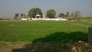
Dewaitha is a village of Dildarnagar Kamsar,in Zamania tehsil of Ghazipur, India, located on the banks of the Karmanasa River and it's tributary Eknaiya, The village had a population of 7,104 as of the 2011 Census of India. The place is inhabited by Kamsar Pathans..
