Dewaitha, formerly known as Daudpur is a historic village established by Dewan Sarkar Raja Daud Khan Zamindar a great-grandson of Narhar Khan the founder of Kamsar region. Narhar's third son, Bahbal Khan had five sons who founded several villages in the Kamsar region. His youngest son Chand Khan receiving his share of estate, established Jaburna. He later distributed his estate among his five sons name as Daud Khan, Hateem Khan, Tajat Khan, Qasim Khan, and Taj Khan .His sons, Hateem & Tajat Khan settled at Jaburna, Qasim Khan founded, nearby Karmahari and Baraura, although his descendants moved to Daltonganj and founder 11 villages there, abandoning the place, they are known as Kamisara Pathans. Taj Khan founded the hamlet, Kesruva. Taj Khan was without issue so his estate was transferred to his brothers. Daud Khan founded Dewaitha in 1605 AD.
A letter of Mughal era, written by Raja Kuttul Khan in farsi, to Man singh Rai of Reotipur, in 1601 AD, some months before his murder.
Daud Khan's cousin, Raja Sarkar Dewan Quttul Khan, Zamindar of TalukaSeorai, re-established the jagir of his great-grandfather, Raja Narhar Khan, known as Kamsar Jagir, comprising 52 villages, and built a fort at Seorai during Akbar's reign. He was later killed in a conflict with Man Singh Rai of Reotipur. Daud Khan avenged his cousin's death and succeeded him as Dewan of the Subah under Jahangir, consolidating his position as jagirdar of the pargana. He expanded his ancestral lands, forming the Daudpur Zamindari estate from Dewaitha to Zamania, with its administrative center fort (Kot) at Dewaitha. In the early 1600s, he built a mosque, Eidgah, and an orchard with thousands of trees, naming the nearby mouzaDaudpur. His eldest son, Mahmud Khan, founded Rasulpur, while his second son, Kabir Khan, gave his name to Kabirpur (Rohura), though most of Kabir's descendants later migrated to Akhlashpur due to family ties. Only part of Daud Khan's kot remains today in Kot Muhalla. The estate flourished under successive generations, notably Raja Yad Ali Khan a sixth-generation descendant, who solidified its prominence. He received a title of Nawab and rais, by the British, which continued in his family. Yad Ali's elder brother, Qadir Khan, is remembered through the nearby hamlet of Qadirpur. During his time estate boundaries touched the borders of zamindari of Amil Chaudhary Azmal of Zamania, he died in 1837AD giving the estate to his eldest grandson Khuda Bhaksh. During the 1857 rebellion, lead by Kunwar singh, Raja Khuda Bhaksh Khan, taluqdar of estate, also led the Kamsaries in the uprising, with his brothers, one of whom, Akbar Khan attaining martyrdom. During the rebellion there was outrage between the zamindars of the region regarding forced cultivation of Opium. After Khuda Bhaksh, his younger brother Amir Khan succeeded him. Dewaitha being a junction of two places, Zamania and Dildarnagar, got name Dewaitha, derived from "Dwi (द्वि): Means "two" or "dual."Aitha: related to something like "coming" or "arrival."Together, "Diwaitha" could meant "a place of two arrivals" or "a junction of two paths and so, the name was registered as Diwaitha.
A image of 1990 showing Dewaitha Jama masjid build by Daud Khan, although it is renovated many times, latest rebuild took during the time of Khuda Bhaksh.
Under British rule, some parts of the Kamsar region fell under the jurisdiction of Amil Deokinandan (Kusi &Usia) and 37 villages taluka to Gaighat, under, Vizianagaram Estate. The Daudpur estate, became small consisting 18 mouzas nearby Dewaitha, but remained under the cheiftiancy control of the family with co-operation, till zamindari abolishment in 1956. Muhammad Wasil Khan , the estate's last chief and taluqdar, became the first pradhan of Dewaitha. He established the village's first primary school and a private medical centre which was operated by a trust of Yad's descendants, Yad Ali's family is known as Athoghar. "In 1940, 502 gold coins were excavated from the village of whom 96 were of Gupta dynasty. The village also celebrates the Urs of a Sufi saint, named Sabir Shah, every year, in the old kot where he lived, Sabir Shah was from Beenapara, though he and his brother lived at Dewaitha, his mazar is at Biur, near Chainpur, while his brother is buried at the Eidgah here.[7][8][9][10][11][12][13][14][15][16][17][18][19][20][21]
A image of the old primary school, at Dewaitha, constructed in 1930s, although in 1974 it was renamed after Sufi saint Sabir Shah.
Demographics
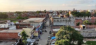
Devaitha, a prominent village in ZamaniaTehsil, Ghazipur district, Uttar Pradesh, has a population of 7,104 across 917 families (2011 Census). Males number 3,685 and females 3,419, with a sex ratio of 928 females per 1,000 males, higher than the state average of 912. The child population (0–6 years) is 1,131 (15.92% of the total), with a child sex ratio of 988, exceeding the state average of 902. The village has a literacy rate of 76.04%, above the state average of 67.68%, with male literacy at 87.20% and female literacy at 63.88%. Governed by an elected Pradhan, Devaitha includes several mohallas like Kot Muhallah, Haji Muhallah, Athoghar, Vichli patti, Purab, Pachim, Uttar, and Dakhin. The Scheduled Caste population is 1,203, with 25 from Scheduled Tribes
In Devaitha, 1,381 residents are involved in various work activities. Among them, 43.74% are engaged in primary employment (work lasting more than six months in a year), while 56.26% participate in marginal work, providing livelihood for less than six months annually. Of those engaged in primary employment, 130 are cultivators (either owners or co-owners of land), and 30 work as agricultural laborers.[23]
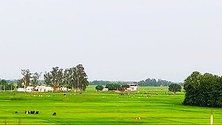
The village's climate is typical of the Gangetic plains, featuring hot summers, monsoon rains, and cool winters. The fertile soil supports the cultivation of crops such as wheat, rice, and sugarcane, with this the village is located in mango belt, the fruits which are native like Blackberry, lychee, Guava, Coconuts, and Mangoes including famous native varieties like Chaunsa and langra, making agriculture a livelihood.[17][24]
Ghazipur district is a district of Uttar Pradesh state in northern India. The city of Ghazipur is the district headquarters. The district is part of Varanasi Division. The region of Ghazipur is famous mainly for the production of its unique rose-scented Spray called Gulab Jal, and for the tomb of the Governor General of British India, Lord Cornwallis, who died here. His tomb is situated in Western part of City, and is conserved by Archaeological Survey of India.
Zamania is a town in the Indian state of Uttar Pradesh. Its municipal council is subordinate to the Ghazipur District. It is also the administrative head of Zamania tehsil,. It is also a very historical town, it derives its name from Ali Quli Khan Zaman, who was also known as Khan Zaman or Zaman Khan, he was a governor of Jaunpur, and Ghazipur during the time of Akbar.
Suhwal is a village of Ghazipur district under Reotipur block. It is situated on Ghazipur to Buxar Road 8 km (5 mi) from Ghazipur City. Its population is 10,814. The Village is quite old. It has its own local administration under the Panchayati Raj system, with Gram Pradhan as head of local administration. There are two Government Secondary Schools, three Government Primary Schools and some privately run Schools. There is a small permanent Market in the western side of the Village and also a weekly Market. Suhwal is a center of Shopping and Primary Education for many other small villages situated on its fringe.
Dildarnagar Kamsar is a pargana (region) and a mashra comprising 34 settlements located around the Karamnasa River in the Ghazipur district of Uttar Pradesh and the Kaimur district of Bihar, India. Of these, 18 mouzas are the primary settlements. It is a prominent settlement of Khanzadas, also known as Kamsari Pathans, as well as Afghan Pathans, primarily of the Niazi and Yusufzai clans. The original name of the region was Kamsar, but due to close and historical ties with the family of Bara Pathans, the region is often referred to as Kamsar-O-Bar. It was established in 1542 by Raja Narhar Khan.
Usia is a village in Kamsaar, Uttar Pradesh, India. It is located southeast of Ghazipur and east of Dildarnagar, near the Bihar State border. The village has a population of 24,786 residents living in 3,471 households. Usia is approximately 7 km from Dildarnagar. Around 8500 Kamsar Pathans lived here as of 2011.
Amir Chak is a village in Kamsaar in the Indian state of Uttar Pradesh.
Kurrah or Tajpur Kurrah is a village in Dildarnagar Kamsar region of Zamania tehsil in Ghazipur district. It is avillage of pathan Kamsaari pathans in the Indian state of Uttar Pradesh. Almost 3900 Kamsaar Pathans lived in the village as of 2011.
Saraila is a village in Kamsaar in the Indian state of Uttar Pradesh.Saraila is a village in Seorai Tehsil in Ghazipur District of Uttar Pradesh, India. It belongs to Varanasi Division. It is located 30 km to the south of District headquarters Ghazipur. 11 km from Seorai. 372 km from State capital Lucknow. The village was also a part of Daudpur Estate which had its capital at Dewaitha during Mughal and early British era.
Jaburna is a village in Kamsaar in the Indian state of Uttar Pradesh.
Fufuao or Rampur Phuphuaon is a village in Dildarnagar Kamsar in the Indian state of Uttar Pradesh.
Seorai is a village of Dildarnagar Kamsar, and also serve as the headquarters of SeoraiTahsil in region of Ghazipur District of Uttar Pradesh, India. The Seorai tehsil was made a tehsil of the Ghazipur District in year 2016. It consists of 142 villages and one town. Seorai main village has a total area of 878.02 hectares and a population of 20000 but its total area is 1,082.83 hectares and a population of 20,530 which also includes Bhadaura. Seorai tehsil has the total area of 366.62 km2 (141.55 sq mi). Seorai also served as the capital of Kamsaar estate from late 1500s to mid 1600s.
Nawali is a village in Seorai tehsil of Ghazipur District, Uttar Pradesh, India.
Kamesarahdih is a hamlet of Dildarnagar Kamsar located in Ghazipur District of Uttar Pradesh, India. Kamesaradih is the main and a historical place of Dildarnagar Kamsar from where Kamsaar Pathans emerged and got their name Kamsaar. Kamesaradih have a kot which was built by Raja Narhar Khan in 1542s. The kot present in Kamesaradih is now under Archaeological Survey of India.
Jalalabad is a large village in Jakhania tehsil located in Ghazipur District of Uttar Pradesh India.
Purani Mosque of Dewaitha was built by Sarkar Dewan Raja Daud Khan Zamindar in 1606 at Dewaitha village. Jama Masjid of Dewaitha is one of the oldest historic monuments in Ghazipur district.
Zamania Canal is one of the largest canals located in Ghazipur District. The idea for the canal was given in 1910 and the plan was passed in 1911, but the canal was established in year 1912 for the better irrigation of Zamania tehsil. It starts from Chakkah Bandh and ends on the banks of Karmanasa River near Bara Village of Seorai Teshsil. It irrigates about 61,863 acres of land in Zamania tehsil. Its average width is 110 ft.
Kabirpur also known as Rohura is a village in Zamania tehsil of Ghazipur District Uttar Pradesh, India. It was a part of Dewaitha but later was made another village in 1953. Kabirpur was established by Raja Kabir Khan.
Tajpur is a village in Zamania tehsil of Ghazipur District, Uttar Pradesh, India. It was a part of Daudpur (Dewaitha) but later it was separated.
Sarhuja is a village of Dildarnagar Kamsar located in Zamania tehsil of Ghazipur district, Uttar Pradesh, India. The village have large population of Kamsaar Pathaans.
Dildarnagar is a municipality in Kamsaar of Ghazipur District, Uttar Pradesh, India. Dildarnagar is a fast-developing town. It is located 34 km from Ghazipur. It is also known as the heart of the Kamsaar-o-Bar region. The total area of Dildarnagar includes Fatehpur Bazar, Dildarnagar Gao, Tajpur, and Nirahukapura. These four neighbourhoods form the town of Dildarnagar. As of the 2011 census, the population of Dildarnagar was 28,913 and the town had an area of 1,995.95 hectares. Dildarnagar is on the road from Varanasi to Buxar. It was also the capital of Dildarnagar Estate.
This page is based on this Wikipedia article Text is available under the CC BY-SA 4.0 license; additional terms may apply. Images, videos and audio are available under their respective licenses.


