
Jaunpur is a city and a municipal board in Jaunpur district in the Indian state of Uttar Pradesh. It is located 228 km southeast of state capital Lucknow. Demographically, Jaunpur resembles the rest of the Purvanchal area in which it is located.

Ghazipur district is a district of Uttar Pradesh state in northern India. The city of Ghazipur is the district headquarters. The district is part of Varanasi Division. The region of Ghazipur is famous mainly for the production of its unique rose-scented Spray called Gulab Jal, and for the tomb of the Governor General of British India, Lord Cornwallis, who died here. His tomb is situated in Western part of City, and is conserved by Archaeological Survey of India.

Bighapur is a town and nagar panchayat in Unnao district of Uttar Pradesh, India. First officially classified as a town for the 1981 census, it now serves as a tehsil headquarters(established in Patan). Important items manufactured here include clay pots, leather products, and wooden furniture. As of 2011, the population of Bighapur is 6,501, in 1,201 households.
Bindki is a city, sub-district and a municipality in Fatehpur district in the state of Uttar Pradesh, India.
Kerakat or Kirakat is a town and nagar panchayat in Jaunpur district of the Indian state of Uttar Pradesh with a population of approximately 13,500. It is situated near the Gomati River, which helps the land around the town stay very fertile. Kerakat or Kirakat forms a part of Varanasi Division. It is located 30 km east of the city of Jaunpur and 279 km from Lucknow, the capital of Uttar Pradesh.
Saurikh is a nagar panchayat in Kannauj district in the Indian state of Uttar Pradesh. Its old name was Sau-Rishi.It is located near main industrial and educational hub of Dibiyapur which is around at a distance of 55 km from the town.
Zamania is a town in the Indian state of Uttar Pradesh. Its municipal council is subordinate to the Ghazipur District.
Gahmar is a village in India, located near the Ganges river in the Ghazipur district in the state of Uttar Pradesh. The village is 38 km from Ghazipur. The village has two post offices, and one Panchayat Bhawan. Gahmar is also known as the "Village of Soldiers".

Buxar is a nagar parishad city in the state of Bihar, India, sharing border with Balia and Ghazipur district of Uttar Pradesh. It is the headquarters of the eponymous Buxar district, as well as the headquarters of the community development block of Buxar, which also contains the census town of Sarimpur along with 132 rural villages.
Suhwal is a village in the Kamsar region of Ghazipur district under Reotipur block. It is situated on Ghazipur to Buxar Road 8 km (5 mi) from Ghazipur City. Its population is 10,814. The Village is quite old. It has its own local administration under the Panchayati Raj system, with Gram Pradhan as head of local administration. There are two Government Secondary Schools, three Government Primary Schools and some privately run Schools. There is a small permanent Market in the western side of the Village and also a weekly Market. Suhwal is a center of Shopping and Primary Education for many other small villages situated on its fringe.
Mania is a village in Kamsaar in the Indian state of Uttar Pradesh. It is located in Zamania Tehsil in the Ghazipur district. It is situated 22 km (14 mi) from the sub-district headquarters Zamania and 31 km (19 mi) from the district headquarters Ghazipur. Its total area is 428.68 hectares and a total population of 5736. Mania village was established in the early 1590 a.d. by Khizir Khan, who was a grandson of Narhar Khan, the founder of Kamsar Pathans.
Fufuao or Rampur Phuphuaon is a village in Dildarnagar Kamsar in the Indian state of Uttar Pradesh.
Bhagwanpur is a Town, Tehsil, and Taluka in Haridwar district in the state of Uttarakhand, India. It is 57 km far from Dehradun which is the capital of Uttarakhand. It is the commercial centre of Ghad Chhetra. It was founded by Bhagwana in the old age Zamindara. It is one of Uttarakhand's industrial zones.

Malwas is a village and post in the Churu district of northern Rajasthan state, India.
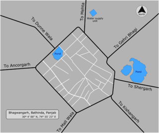
Bhagwangarh, also known as Bhukhianwali is a village of Talwandi Sabo tehsil of Bathinda district of Indian Panjab.
Bhimapar is a village and a Gram panchayat in Ghazipur district of Uttar Pradesh, India. Bhimapar is a developing and new face town. It is 57 km from Varanasi and 57 km from Ghazipur.
Ratanpura is a census town in the Mau district of Uttar Pradesh. It is located about 25 kilometres east of the district headquarters, Mau, and 47 Kilometres west of Ballia. It is a development block headquarter, which comes under the Mau Sadar Tehsil. The town is situated between the middle of Mau and Ballia. The State Highway 34 passes through Ratanpura. Earlier it was a part of Ballia district, but since 19 November 1988 it became the part of newly constituted Mau District. The town has its own Railway station managed by North Eastern Railway (India) in its name which has connecting trains to Mau, Varanasi, Ballia, Lucknow, Kanpur, Azamgarh, Chhapra and Dhanbad stations to name a few.

Zamania Canal is one of the largest canals located in Ghazipur District. The idea for the canal was given in 1910 and the plan was passed in 1911, but the canal was established in year 1912 for the better irrigation of Zamania tehsil. It starts from Chakkah Bandh and ends on the banks of Karmanasa River near Bara Village of Seorai Teshsil. It irrigates about 61,863 acres of land in Zamania tehsil. Its average width is 110 ft.
Dildarnagar is a municipality in Kamsaar of Ghazipur District, Uttar Pradesh, India. Dildarnagar is a fast-developing town. It is located 34 km from Ghazipur. It is also known as the heart of the Kamsaar-o-bar region. The total area of Dildarnagar includes Fatehpur Bazar, Dildarnagar Gao, and Nirahukapura. These four neighbourhoods form the town of Dildarnagar. As of the 2011 census, the population of Dildarnagar was 28,913 and the town had an area of 1,995.95 hectares. Dildarnagar is on the road from Varanasi to Buxar. It was also the capital of Dildarnagar Estate.

Dewaitha is a village in Dildarnagar Kamsar, Ghazipur, India, on the banks of the Karmanasa River. The village had a population of 7,706 as of the 2011 Census of India and a land area of 1,043 acres. Most of the people living in the village are Kamsar Pathan.
