
Rampur district is one of the districts of Uttar Pradesh state of India, and Rampur town is the district headquarters. Rampur district is a part of Moradabad division. The district occupies an area of 2,367 km2 (914 sq mi).

Ghazipur district is a district of Uttar Pradesh state in northern India. The city of Ghazipur is the district headquarters. The district is part of Varanasi Division. The region of Ghazipur is famous mainly for the production of its unique rose-scented Spray called Gulab Jal, and for the tomb of the Governor General of British India, Lord Cornwallis, who died here. His tomb is situated in Western part of City, and is conserved by Archaeological Survey of India.
Kemri is a town and nagar panchayat in Rampur district in the Indian state of Uttar Pradesh.

Kadipur is a town, tehsil and a nagar panchayat in Sultanpur district in the Indian state of Uttar Pradesh. It is located a short distance from the bank of the Gomti River, at a crossroads between two roads heading from Sultanpur to Surapur and from Pratapgarh to Dostpur and then on to Akbarpur. On the north side of town is a stream with a steep ravine that drains the surrounding area. The road to Sultanpur crosses over this stream on a bridge. The lands surrounding Kadipur are average quality for agricultural purposes. As of 2011, Kadipur has a population of 8,010 people, in 1,216 households.
Kairana is a city and a municipal board in Shamli district of the Indian state of Uttar Pradesh. It is approximately 14 km (8.7 mi) from Shamli city.
Parsadepur, also spelled Parshadepur, is a town and a nagar panchayat in Rae Bareli district in the Indian state of Uttar Pradesh. It is located on the north bank of the Sai river, at the crossroads between the road from Salon to Jais and the smaller road from Raebareli to Ateha. Historically noted for its large weaving industry, Parsadepur served as the headquarters of a pargana since the late 18th century. As of 2011, its population is 11,853 people, in 1,738 households.
Zamania is a town in the Indian state of Uttar Pradesh. Its municipal council is subordinate to the Ghazipur District. It is also the administrative head of Zamania tehsil,. It is also a very historical town, it derives its name from Ali Quli Khan Zaman, who was also known as Khan Zaman or Zaman Khan, he was a governor of Jaunpur, and Ghazipur during the time of Akbar.
Dildarnagar Kamsar is a pargana (region) and a mashra comprising 34 settlements located around the Karamnasa River in the Ghazipur district of Uttar Pradesh and the Kaimur district of Bihar, India. Of these, 18 mouzas are the primary settlements. It is a prominent settlement of Khanzadas, also known as Kamsari Pathans, as well as Afghan Pathans, primarily of the Niazi and Yusufzai clans. The original name of the region was Kamsar, but due to close and historical ties with the family of Bara Pathans, the region is often referred to as Kamsar-O-Bar. It was established in 1542 by Raja Narhar Khan.
Usia is a village in Kamsaar, Uttar Pradesh, India. It is located southeast of Ghazipur and east of Dildarnagar, near the Bihar State border. The village has a population of 24,786 residents living in 3,471 households. Usia is approximately 7 km from Dildarnagar. Around 8500 Kamsar Pathans lived here as of 2011.
Amir Chak is a village in Kamsaar in the Indian state of Uttar Pradesh.
Rakasaha is a village in Kamsaar in the Indian state of Uttar Pradesh. Almost 6500 Kamsaar Pathans(NAWABS) lived in the village as of 2011.

Kurrah or Tajpur Kurrah is a village in Dildarnagar Kamsar region of Zamania tehsil in Ghazipur district. It is avillage of pathan Kamsaari pathans in the Indian state of Uttar Pradesh. Almost 3900 Kamsaar Pathans lived in the village as of 2011.

Saraila is a village in Kamsaar in the Indian state of Uttar Pradesh.Saraila is a village in Seorai Tehsil in Ghazipur District of Uttar Pradesh, India. It belongs to Varanasi Division. It is located 30 km to the south of District headquarters Ghazipur. 11 km from Seorai. 372 km from State capital Lucknow. The village was also a part of Daudpur Estate which had its capital at Dewaitha during Mughal and early British era.
Bahuara is a village in Kamsaar in the Indian state of Uttar Pradesh. Bahuara is a village with a population of almost 5000. It is surrounded by others Kamsar villages. Bahuara is well connected with the town of Dildarnagar which is hardly 2-3 kilometres away from the village. People of Bahuara are scattered throughout the world. Ancestrally, the people of bahuara have been a land-owning (Zamindar) community divided into two colonies Westside & Eastside. Neighbouring villages are Rakhsaha, Dildarnagar, and others.
Mania is a village in Kamsaar in the Indian state of Uttar Pradesh. It is located in Seorai Tehsil in the Ghazipur district. It is situated 22 km (14 mi) from the sub-district headquarters Seorai and from the district headquarters Ghazipur. Its total area is 428.68 hectares and a total population of 5736. Mania village was established in the early 1590 a.d. by Khizir Khan, who was a grandson of Narhar Khan.
Chitarkoni is a village in Kamsaar in the Indian state of Uttar Pradesh.
Seorai is a village of Dildarnagar Kamsar, and also serve as the headquarters of SeoraiTahsil in region of Ghazipur District of Uttar Pradesh, India. The Seorai tehsil was made a tehsil of the Ghazipur District in year 2016. It consists of 142 villages and one town. Seorai main village has a total area of 878.02 hectares and a population of 20000 but its total area is 1,082.83 hectares and a population of 20,530 which also includes Bhadaura. Seorai tehsil has the total area of 366.62 km2 (141.55 sq mi). Seorai also served as the capital of Kamsaar estate from late 1500s to mid 1600s.
Nawali is a village in Seorai tehsil of Ghazipur District, Uttar Pradesh, India.
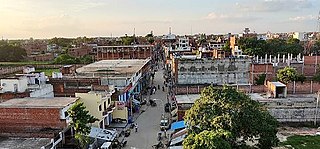
Dildarnagar is a municipality in Kamsaar of Ghazipur District, Uttar Pradesh, India. Dildarnagar is a fast-developing town. It is located 34 km from Ghazipur. It is also known as the heart of the Kamsaar-o-Bar region. The total area of Dildarnagar includes Fatehpur Bazar, Dildarnagar Gao, Tajpur, and Nirahukapura. These four neighbourhoods form the town of Dildarnagar. As of the 2011 census, the population of Dildarnagar was 28,913 and the town had an area of 1,995.95 hectares. Dildarnagar is on the road from Varanasi to Buxar. It was also the capital of Dildarnagar Estate.
Dewaitha is a village of Dildarnagar Kamsar,in Zamania tehsil of Ghazipur, India, located on the banks of the Karmanasa River and it's tributary Eknaiya, The village had a population of 7,104 as of the 2011 Census of India. The place is inhabited by Kamsar Pathans..