This article ia about the transport in Zambia.
This article deals with the disputed area on the borders of the Democratic Republic of the Congo and Zambia, in Luapula Province.

The Luapula River is a section of Africa's second-longest river, the Congo. It is a transnational river forming for nearly all its length part of the border between Zambia and the DR Congo. It joins Lake Bangweulu to Lake Mweru and gives its name to the Luapula Province of Zambia.
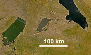
Lake Mweru Wantipa or Mweru-wa-Ntipa meaning "muddy lake" is a lake and swamp system in the Northern Province of Zambia. It has been regarded in the past as something of mystery, displaying fluctuations in water level and salinity which were not entirely explained by variation in rainfall levels; it has been known to dry out almost completely. This is compounded by its remoteness and it not receiving the same attention from geographers and geologists as its larger and more accessible neighbours, Lake Tanganyika, 25 km east, and Lake Mweru, 40 km west, with which its name is sometimes confused.

Northern Province is one of Zambia's ten provinces. It covers approximately one sixth of Zambia in land area. The provincial capital is Kasama. The province is made up of 8 districts, namely Kasama, Chilubi, Kaputa, Luwingu, Mbala, Mporokoso, Mpulungu and Mungwi. Currently, only Kasama and Mbala have attained municipal council status, while the rest are still district councils. It is widely considered to be the heartland of the Bemba, one of the largest tribes in Zambia.

Nchelenge is a town in the Luapula Province of northern Zambia, lying on the south eastern shore of Lake Mweru. It is contiguous with Kashikishi, and they are sometimes referred to as Nchelenge-Kashikishi. Nchelenge is the administrative centre for the Zambian part of Lake Mweru, being the seat of the district government and branches of national agencies, while Kashikishi is the market and fisheries centre.

Mansa is the capital of the Luapula Province of Zambia, and headquarters of Mansa District. It takes its name from the local Chief Mansa and the small Mansa River which flows west to the Luapula River. During British rule the city was named Fort Rosebery.
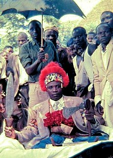
Kazembe is a traditional kingdom in modern-day Zambia, Southeastern Congo. For more than 250 years, Kazembe has been an influential kingdom or chieftainship of the Kiluba-Chibemba, speaking the Swahili language or the language of the Eastern Luba-Lunda people of south-central Africa. Its position on trade routes in a well-watered, relatively fertile and well-populated area of forestry, fishery and agricultural resources drew expeditions by traders and explorers who called it variously Kasembe, Cazembe and Casembe.
Kashikishi is a town on the south-eastern shore of Lake Mweru in the Luapula Province of Zambia. It lies just north of the district headquarters Nchelenge, and close enough for them to be considered twin towns; they are sometimes referred to as Nchelenge–Kashikishi.
Kazembe is a name used for Mwata Kazembe's town in the Luapula Province of Zambia, especially on maps and in the Zambian postal service. However, the correct name for the town is Mwansabombwe and this is the one used by its or Luba or Chibemba-speaking inhabitants. They may refer in English to "Kazembe's Village" or just "Kazembe", as traditionally a settlement is named after the chief or headman, rather than the location. The Luba-Lunda shared with many tribes the custom of moving to another village or a new site on the death of the chief. Historical references to a village or town may actually be to a different location. For instance when the explorer David Livingstone visited Mwata Kazembe in 1867 and 1868, "Casembe's town", as he wrote it, was further north at the town now called Kanyembo.
Kanyembo is the principal centre of the population on the Mofwe Lagoon, the largest of several lagoons in the Luapula River swamps south of Lake Mweru, in the Luapula Province of Zambia. It takes its name from its traditional ruler, Chief Kanyembo, one of the senior chiefs of the Kazembe-Lunda under Mwata Kazembe. In the past the incumbent Chief has been promoted to Mwata, and Kanyembo was the site of Mwata Kazembe's capital when it was visited by David Livingstone in 1867.
Water transport. and the many navigable inland waterways, in Zambia has a long tradition of practical use in Zambia except in parts of the south. Since draught animals such as oxen were not heavily used, water transport was usually the only alternative to going on foot until the 19th Century. The history and current importance of Zambian waterways, as well as the types of indigenous boats used, provide information on this important aspect of Zambian economy.

Chiengi or Chienghospital historic colonial boma of the British Empire in central Africa and today is a settlement in the Luapula Province of Zambia, and headquarters of Chiengi District. Chiengi is in the north-east corner of Lake Mweru, and at the foot of wooded hills dividing that lake from Lake Mweru Wantipa, and overlooking a dambo stretching northwards from the lake, where the Chiengi rivulet flows down from the hills.
The biomes and ecoregions in the ecology of Zambia are described, listed and mapped here, following the World Wildlife Fund's Global 200 classification scheme for terrestrial ecoregions, and the WWF freshwater bioregion classification for rivers, lakes and wetlands. Zambia is in the Afrotropic biogeographic realm of the scheme. Three terrestrial biomes are well represented in the country . The distribution of the biomes and ecoregions is governed mainly by the physical environment, especially climate.

Chiengi District with headquarters at Chiengi is the smallest and most northerly district in the Luapula Province of Zambia and was carved out of Nchelenge District after Zambia's independence. As of the 2010 Zambian Census, the district had a population of 109,147 people. Most of its population live in fishing villages along the 70 km (approx.) of the north-east shore of Lake Mweru which lies within the district. The largest settlement is Puta, 5 km south of Chiengi town, named after Chief Puta. The district is bounded by the DR Congo border in the north, Kaputa District in the east and the Kalungwishi River in the south.
Isokwe is an island on Lake Mweru in Luapula Province, Zambia. Isokwe is occupied, and is 7 kilometres (4.3 mi) long and up to 2 kilometres (1.2 mi) wide. It is located about 5 kilometres outside the city of Kashikishi.

Nchelenge District is a district of Zambia, located in the Luapula Province. The capital lies at Nchelenge. As of the 2000 Zambian Census, the district had a population of 111,119 people.