Kagoma, Nigeria

Last updated

Kagoma
Gwong
Kpop Gwong palace 1.jpg
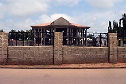
Kpop Gwong's new palace under construction
Nickname: 
K10
Nigeria location map.svg
Red pog.svg
Kagoma
Coordinates: 09°31′N08°11′E / 9.517°N 8.183°E / 9.517; 8.183 [1]
CountryFlag of Nigeria.svg  Nigeria
State Kaduna State
LGA Jema'a
Government
  Kpop Gwong Kpop (Col.) Paul Zakka Wyom (rtd.)
Time zone UTC+01:00 (WAT)
Climate Aw

Kagoma is a district of Jema'a Local Government Area, southern Kaduna state in the Middle Belt region of Nigeria. [2] The postal code for the village is 801104. [3] [4] [5]

Contents

A corn field along Kagoma-Kwain (Kwoi) road A corn field along Kagoma-Kwain road 2.jpg
A corn field along Kagoma-Kwain (Kwoi) road
Kpop Gwong new palace site Kpop Gwong new palace site.jpg
Kpop Gwong new palace site

People

Language

Transportation

Junction to Kagoma town Fadan Kagoma junction 1.jpg
Junction to Kagoma town

The major means of transportation in and around the town is road transportation.

Related Research Articles

Kaduna North, often referred to as the pioneer local government, is a Local Government Area in Kaduna State, Nigeria. It is the capital of Kaduna State and its headquarters are in the town of Doka. Its postal code is 800. It has an area of 70.2 km2.

<span class="mw-page-title-main">Kaduna South</span> LGA in Kaduna State, Nigeria

Kaduna South is a Local Government Area in the Kaduna Metropolis of Kaduna State, Nigeria. Its headquarters is located in Makera. Other wards are Barnawa, Tudun Wada, Tudun Nupawa, Television, Kakuri, Unguwar Muazu, Kabala West, Sabon Gari, Badikko, Unguwar Sanusi and Kurmin Mashi. It has an area of about 46.2 km2. The postal code of the area is 800.

Sanga is a Local Government Area in southern Kaduna State, Nigeria. Its headquarters is in the town of Gbantu. The Local Government Council is chaired by Bisallah Malam. It has an area of 1,821 km2 and had a population of 151,485 as at the 2006 census. The postal code of the area is 801.

<span class="mw-page-title-main">Jema'a</span> LGA and Town in Kaduna State, Nigeria

Jema'a is a Local Government Area in southern Kaduna State, Nigeria with headquarters at Kafanchan. The Local Government Council is chaired by Yunana Barde. It has an area of 1,384 km2 and a population of 278,202 at the 2006 census. The postal code of the area is 801.

Kaura is a town and a Local Government Area in southern Kaduna State, Nigeria. Its headquarters are in the town of Kaura in Asholyio (Moroa) Chiefdom. The Local Government Council is chaired by Matthias Siman. Other towns include: Manchok and Kagoro. It has an area of 461 km2 and a population of 174,626 at the 2006 census. The postal code of the area is 801.

<span class="mw-page-title-main">Jaba, Nigeria</span> LGA in Kaduna State, Nigeria

Jaba is a Local Government Area in southern Kaduna State, Nigeria. It covers an area of 531 km2. It is located close to the Jos Plateau region and Abuja in the central part of Nigeria in West Africa. The local government capital is in the town of Kwoi. The postal code of the area is 801. The Chairman of the local government oversee both economic and developmental activities in the area.

Zangon Kataf is a Local Government Area in southern Kaduna State, Nigeria. Its headquarters is in the town of Zonkwa. It is also a name of a town in the chiefdom of the Atyap. Other towns include: Batadon (Madakiya), Chenkwon, Kamantan, Anchuna and Kamuru. It has an area of 2,579 km2 and a population of 318,991 at the 2006 census. The postal code of the area is 802.

Patrick Ibrahim Yakowa was a Nigerian politician who served as governor of Kaduna State from 2010 to 2012. He was appointed deputy governor of Kaduna State in July 2005, following the death of Stephen Shekari and was elected in 2007. He was sworn in as governor on 20 May 2010, replacing Governor Namadi Sambo who had been sworn in as vice president the day before. Yakowa successfully ran for election as Kaduna Governor in the 26 April 2011 polls.

Gyong, also known as Kagoma, is a Plateau language of Nigeria. It is spoken by the Gwong people, whose indigenous homeland is in Jema'a Local Government Area in the southern part of Kaduna State, Nigeria.

Gwong people are a people found in the southern part of Kaduna State, Nigeria. Their language, Gyong language belongs to the central plateau language group. Their headquarters is at Fadan Kagoma, Jema'a Local Government Area of the state.

Kamuru is a town in Zangon Kataf Local Government Area in southern Kaduna state in the Middle Belt region of Nigeria. It is the headquarters of the Akulu chiefdom. The postal code of the area is 802.

<span class="mw-page-title-main">Godogodo</span> Town in southern Kaduna

Godogodo is a district as well as a town in Jema'a Local Government Area in southern Kaduna state in the Middle Belt region of Nigeria. It is also the Godogodo Chiefdom headquarters. The town has a post office, with a postal code 801103. It also houses an old tin mining tunnel site located along the town, one of the oldest tin mining site is known as.

Taligan (Magamiya) is a village community in Zonzon district of Zangon Kataf Local Government Area, southern Kaduna state in the Middle Belt region of Nigeria. The postal code for the village is 802143. The nearest airport to the community is the Yakubu Gowon Airport, Jos.

Kagoma may refer to:

<span class="mw-page-title-main">Takau District</span> District in Kaduna State, Nigeria

Takau is a district in Fantswam (Kafanchan) Chiefdom of Jema'a Local Government Area in southern Kaduna state in the Middle Belt region of Nigeria. It is a suburban area of the town of Kafanchan. The postal code of the area is 801139.

Zonzon is a district and a village community in Zangon Kataf Local Government Area, southern Kaduna state in the Middle Belt region of Nigeria. The postal code for the area is 802138.

<span class="mw-page-title-main">Gidan Waya</span> Town in Kaduna State, Nigeria

Gidan Waya is a small town and Headquarters of Godogodo chiefdom about 18 km from Kafanchan in Jema'a Local Government Area of southern Kaduna state in the Middle Belt region of Nigeria. The town has a post office.

Chawai is a town east of the headquarters of the Tsam Chiefdom of the Atsam people in Kauru Local Government Area in southern Kaduna state in the Middle Belt region of Nigeria. The postal code of the area is 811.

Antang is a village and district in Jema'a Local Government Area, southern Kaduna State, Middle Belt, Nigeria. It is located 163.93 km from the state capital, Kaduna. The postal code of the area is 801. The village is 1,850 ft above sea level.

Atuku is a village and a second-order administrative divisions in Jema'a Local Government Area, southern Kaduna State, Middle Belt, Nigeria. It is located 159.08 km from the state capital, Kaduna. The postal code of the area is 801.

References

  1. "Fadan Kagoma Map - Satellite Images of Fadan Kagoma". maplandia.com. Retrieved September 25, 2020.
  2. "Kagoma, Jema'A, Kaduna State, Nigeria". mindat.org. Retrieved September 25, 2020.
  3. "Nigeria Postcode" . Retrieved September 25, 2020.
  4. "Post Offices- with map of LGA". NIPOST. Archived from the original on 2009-10-07. Retrieved 2020-09-25.
  5. "Kagoma/Asso Post Codes: Nigeria". World Postal Code. Retrieved September 25, 2020.

Commons-logo.svg Media related to Kagoma, Nigeria at Wikimedia Commons