
Aung San Suu Kyi is a Burmese politician, diplomat, author, and a 1991 Nobel Peace Prize laureate who served as State Counsellor of Myanmar and Minister of Foreign Affairs from 2016 to 2021. She has served as the president of the National League for Democracy (NLD) since 2011, having been the General Secretary from 1988 to 2011. She played a vital role in Myanmar's transition from military junta to partial democracy in the 2010s.

Myanmar or Burma, officially the Republic of the Union of Myanmar, is a country in Southeast Asia. Myanmar is bordered by Bangladesh and India to its northwest, China to its northeast, Laos and Thailand to its east and southeast, and the Andaman Sea and the Bay of Bengal to its south and southwest. Myanmar is the largest country in Mainland Southeast Asia and the 10th largest in Asia by area. As of 2017, the population was about 54 million. Its capital city is Naypyidaw, and its largest city is Yangon (Rangoon).

Mandalay is the second-largest city in Myanmar, after Yangon. Located on the east bank of the Irrawaddy River, 716 km (445 mi) north of Yangon, the city has a population of 1,225,553.
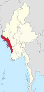
Rakhine State is a state in Myanmar (Burma). Situated on the western coast, it is bordered by Chin State to the north, Magway Region, Bago Region and Ayeyarwady Region to the east, the Bay of Bengal to the west and the Chittagong Division of Bangladesh to the northwest. It is located approximately between latitudes 17°30' north and 21°30' north and longitudes 92°10' east and 94°50' east. The Arakan Mountains or Rakhine Yoma separated Rakhine State from central Burma from North to South. Off the coast of Rakhine State there are some fairly large islands such as Ramree, Cheduba and Myingun. Rakhine State has an area of 36,762 square kilometres (14,194 sq mi) and its capital is Sittwe.

The kyat is the currency of Myanmar (Burma). It is often abbreviated as "K" or "Ks" (plural), which is placed before or after the numerical value, depending on author preference.

Monywa is the largest city in Sagaing Region, Myanmar, located 136 km north-west of Mandalay on the eastern bank of the River Chindwin. Monywa is one of the largest economic cities in Myanmar.

Burmese pagodas are stupas that typically house Buddhist relics, including relics associated with Buddha. Pagodas feature prominently in Myanmar's landscape, earning the country the moniker "land of pagodas." According to 2016 statistics compiled by the State Sangha Maha Nayaka Committee, Myanmar is home to 1,479 pagodas exceeding 27 feet (8.2 m) in height, a quarter of which are located in Sagaing Region. Several cities in the country, including Mandalay and Bagan, are known for their abundance of pagodas. Pagodas are the site of seasonal pagoda festivals.

Yawnghwe, known as Nyaungshwe in Burmese, was a Shan state in what is today Myanmar. It was one of the most important of the Southern Shan States. Yawnghwe state included the Inle Lake. The administrative capital was Taunggyi, located in the northern part of the state. The Agent of the British government, the Superintendent of the Southern Shan States, resided at Taunggyi and the king's palace was at Yawnghwe.

The Ananda Temple, located in Bagan, Myanmar is a Buddhist temple built in 1105 AD during the reign (1084–1112/13) of King Kyansittha of the Pagan Dynasty. The temple layout is in a cruciform with several terraces leading to a small pagoda at the top covered by an umbrella known as hti, which is the name of the umbrella or top ornament found in almost all pagodas in Myanmar. The Buddhist temple houses four standing Buddhas, each one facing the cardinal direction of East, North, West and South. The temple is said to be an architectural wonder in a fusion of Mon and adopted Indian style of architecture. The impressive temple has also been titled the "Westminster Abbey of Burma". The temple has close similarity to the Pathothamya temple of the 10th–11th century, and is also known as “veritable museum of stones”.

Phaung Daw U Pagoda, also spelt Phaung Daw Oo or Hpaung Daw Oo, is a notable Buddhist site in Myanmar, located in the village of Ywama on Inle Lake in Shan State. The pagoda is the site of a major annual pagoda festival during which the temple's principal Buddha images are circulated on a royal barge across Inle Lake.

Kyainseikgyi is a town in Kayin State, Myanmar, located on the eastern side of the Zami River. It is the administrative center of the Kyain Seikgyi Township.

Papun is a town in Kayin State, Myanmar. It is on the east side of the Yunzalin River. It was formerly one of the headquarters of the Karen National Union and the Karen National Liberation Army. The Papun Airport is also located nearby.

Khamti, Hkamti, Singkawng, Kanti or Kantee is a town in Hkamti District, Sagaing Division, in north-western Myanmar. It is the administrative center for both the district and Hkamti Township.

Uppātasanti Pagoda is a prominent landmark in Naypyidaw, the capital of Myanmar. The pagoda houses a Buddha tooth relic from China. It is nearly a same-sized replica of Shwedagon Pagoda in Yangon and stands 99 metres (325 ft) tall.

The ordination hall is a Buddhist building specifically consecrated and designated for the performance of the Buddhist ordination ritual (upasampada) and other ritual ceremonies, such as the recitation of the Patimokkha. The ordination hall is located within a boundary that defines "the space within which all members of a single local community have to assemble as a complete Sangha at a place appointed for ecclesiastical acts ." The constitution of the sīmā is regulated and defined by the Vinaya and its commentaries and sub-commentaries.

Kyauktawgyi Buddha Temple is a Buddhist temple located on Mindhamma Hill on Mingaladon Township, Yangon, Burma. The temple houses a 25 feet (7.6 m) feet tall Buddha called the Loka Chantha Abhaya Labha Muni, which is carved out of a single piece of white marble quarried in Sagyin Hill, Madaya Township, Mandalay Region. The image weighs approximately 560 tons. The Buddha is carved making the abhayamudra (အဘယမုဒြာ), the gesture of fearlessness.
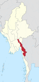
Kayin State, the name given by the Burmese military government to Karen State, is a state of Myanmar. The capital city is Hpa-An, also spelled Pa-An.
Paingkyon is a town in Hlaingbwe Township, Hpa-an District, in the Kayin State of Myanmar.
Sukali is a town in Myawaddy Township, Myawaddy District, in the Kayin State of Myanmar.
The Man Buddha Temple is a Buddhist temple in Sale, Magway Region, Myanmar that houses the Shinbin Maha Laba Man Buddha.

