Kaiperambalur

Last updated

Kaiperambalur
Kulothunga Chozhapuram
Panchayat village
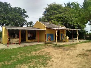
Kaiperambalur.jpg
Kaiperambalur Aerial view
India Tamil Nadu location map.svg
Red pog.svg
Kaiperambalur
Location in Tamil Nadu, India
India location map.svg
Red pog.svg
Kaiperambalur
Kaiperambalur (India)
Coordinates: 11°21′36″N79°05′53″E / 11.360°N 79.098°E / 11.360; 79.098 Coordinates: 11°21′36″N79°05′53″E / 11.360°N 79.098°E / 11.360; 79.098
CountryFlag of India.svg  India
State Tamil Nadu
District Perambalur
Founded byVanniya Kula Sathriya
Government
  TypePublic
  BodyTamil Nadu
  RankNo 1
Population
  Total10,024
  Rank1024
Languages
  Official Tamil
Time zone UTC+5:30 (IST)
PIN
621716. [1]
Telephone code04328
Vehicle registration TN46, TN45
Nearest city Perambalur, Ariyalur, Thittakudi, Trichy.
Literacy72%
Climate cool- hat-cool (Köppen)

Kaiperambalur is a panchayat village of the Kizhamathdur district in Perambalur, Tamil Nadu, India. It was formally part of the Tiruchirappalli district.

Contents

History

The historical name of Kaiperambalur is கைப்பெரம்பலூர் (Kaippěrampalūr) or Kapparampoor. During the Kulothunga Cholas (c. 1070–1218 CE), this village was noted for its monthly festivals. Two important temples were built: "Siva Temple" and "Lord Perumal Temple". Today, these temples are two of the oldest and most affluent temples in India.

Centuries later, the postal department of India renamed the village to "Kaiperambalur."

Due to the large limestone deposits in the region, many companies within the cement industry have sites in the vicinity of this village. In particular, the factories for the cement companies, Arasu, Birla, Sakthi, Dalmia, and Tamil Nadu, are situated near Ariyalur.

Kaiperambalur is also notable for the Iyyanar Temple situated 25 km from Kaiperambalur. Gangaikonda Cholapuram is also nearby. Gangaikonda Cholapuram is famous for its temple built by King Rajendra Cholan of Chola Empire. King Rajendra Cholan was the son of Rajaraja Cholan who built Tanjore Temple.

Geography

The village is bordered by fertile lands due to the many streams around it, including

SummerWinter
Max.40 °C (104 °F)30 °C (86 °F)
Min.22 °C (72 °F)18 °C (64 °F)

More detail about Kaiperambalur

Kaiperambalur is a small village in Veppur Taluk in Perambalur District of Tamil Nadu State, India. It comes under Kilumathur North Panchayath.

It is located 34 km to the east of district headquarters Perambalur, 9 km from Veppur, 265 km from state capital Chennai Kaiperambalur. Pin code is 621716 and postal head office is Tungapuram. Athiyur (4 km), Vadakkalur (5 km).

Ogalur (6 km), Veppur (6 km), Nannai (7 km) are the nearby villages to Kaiperambalur. Kaiperambalur is surrounded by Mangalur Taluk to the north, Sendurai Taluk to the east, Nallur Taluk to the east, Ariyalur Taluk to the south.

Tittakudi, Perambalur, Virudhachalam, Neyveli are the nearby cities to Kaiperambalur.

This place is in the border of the Perambalur District and Ariyalur District. Ariyalur District Ariyalur is south of this place. Also it is in the border of other district Cuddalore.

Politics

Before 1995, Kaiperambalur was under Perambalur Taluk and the Tiruchirappalli district. The composite Perambalur District came into existence after the trifurcation of Tiruchirappalli district on 30 September 1995 as per G.O MS.No 913 Revenue / Y3 dated 30 September 1995. It is now subject to "Kunnam Taluk" in Perambalur district.

The constituency of the Kaiperambalur assembly is part of the Chidambaram (Lok Sabha constituency). [2]

Kizhumathur panchayat was created from the Kaiperamablur North East and Kudikadu North regions; The villages of Kaiperamablur and Kudikadu belong to the Kizhumathur North region. The villages of Kaiperambalur, G.R. Pattanam, and Poonganagarm belong to the Kizhumathur East region.

Related Research Articles

<span class="mw-page-title-main">Thiruvaiyaru</span> Panchayat Town in Tamil Nadu, India

Thiruvaiyaru is a panchayat town in Thanjavur District in the Indian state of Tamil Nadu.

<span class="mw-page-title-main">Gangaikonda Cholapuram</span> Town in Tamil Nadu, India

Gaṅgaikoṇḍa Chōḻapuram is a village located near to Jayankondam, Ariyalur district, Tamil Nadu, India. It became the capital of the Chola dynasty in c. 1025 by Chola emperor Rajendra I, and served as the capital for around 250 years.

<span class="mw-page-title-main">Ariyalur district</span> District of Tamil Nadu in India

Ariyalur district is an administrative district, one of the 38 districts in the state of Tamil Nadu in India. The district headquarters is located at Ariyalur. The district encompasses an area of 1,949.31 km².

<span class="mw-page-title-main">Perambalur district</span> District of Tamil Nadu in India

Perambalur is one of the 38 districts in the state of Tamil Nadu, India. The district headquarters is located at Perambalur. The district occupies an area of 1,752 km² and had a population of 565,223 with a sex-ratio of 1,003 females for every 1,000 males in 2011.

<span class="mw-page-title-main">Rajendra Chola I</span> Chola emperor from 1014–1044

Rajendra Chola I(/rɑːdʒeɪndrə/; Middle Tamil: Rājēntira Cōḻaṉ; Classical Sanskrit: Rājēndradēva Cōla; Old Malay: Raja Chulan; c. 971 CE – 1044 CE), often referred to as Rajendra the Great, and also known as Gangaikonda Cholan, and Kadaram Kondan was a Chola Emperor who reigned between 1014 and 1044 CE. He is considered the most significant ruler in early eleventh-century South Asia for his role in patronising the arts, encouraging trade and expanding the Chola Empire to its greatest extent.

<span class="mw-page-title-main">Chola Nadu</span> Region of Tamil Nadu

Chola Nadu is a cultural region of the Tamil Nadu state in southern India. It encompasses the lower reaches of the Kaveri River and its delta, and formed the cultural homeland and political base of the Chola Dynasty which ruled large parts of South India and parts of Sri Lanka between the 9th and 13th centuries CE. Uraiyur served as the early Chola capital, then medieval Cholas shifted to Thanjavur and later cholas king Rajendra Chola I moved the capital to Gangaikonda Cholapuram in Ariyalur in the 11th century CE.

<span class="mw-page-title-main">Tiruchirappalli district</span> District of Tamil Nadu in India

Tiruchirappalli District is one of the 38 districts, located along the Kaveri River, in Tamil Nadu, India. The headquarters of the district is the city of Tiruchirappalli.

<span class="mw-page-title-main">Jayankondam</span> Town in Tamil Nadu, India

Jayankondam is a Municipality in Ariyalur district of Tamil Nadu in India. As of 2022, the town had a population of 45,000.

Kattumannarkoil is a panchayat town and taluk headquarters in Cuddalore district in the Indian state of Tamil Nadu. Kattumannarkoil Town Panchayat constituted in 1892. The town is coming under the administrative territory of Cuddalore District. The town extends over an area of 19.425 km2. The town is situated along 25 km South West of Chidambaram and lies on the Chidambaram - Coimbatore Highway and 25 km East of Srimushnam and a similar distance north-east of Gangaikonda Cholapuram. The entire road route from Sethiathoppu to Kattumannarkoil runs alongside the Veeranam Lake. The newly built Muttam bridge provides connectivity to Mayladuthurai in the south at the distance of 30 km.

<span class="mw-page-title-main">Thuraiyur</span> Municipality in Tamil Nadu, India

Thuraiyur is a town and a municipality in the Tiruchirappalli district in the Indian state of Tamil Nadu. It was upgraded to a III Grade Municipality from Town Panchayat on 17 January 1970, and to a II Grade Municipality in May 1998. It was upgraded to Selection Grade Municipality in the year 2008. It is also a taluka. It is located 310 km away from Chennai.

<span class="mw-page-title-main">Udayarpalayam</span> Town Panchayat in Tamil Nadu, India

Udayarpalayam is a panchayat town in the Ariyalur district of the Indian state of Tamil Nadu, near Jayankondam.

<span class="mw-page-title-main">Ariyalur</span> Town in Tamil Nadu, India

Ariyalur is a town and district headquarters of Ariyalur district in the South Indian state of Tamil Nadu and is rich in limestone, surrounded with seven cement factories and two sugar factories. The town is located at a distance of 310 km (190 mi) from the state capital Chennai.

Perambalur taluk is a taluk of Perambalur district in Tamil Nadu, India. Its headquarters is the town of Perambalur.

Thuthur is a village in the Ariyalur taluk of Ariyalur district, Tamil Nadu, India.

<span class="mw-page-title-main">Thungapuram</span> Panchayat village in Tamil Nadu, India

Thungapuram is a panchayat village of Perambalur district, Tamil Nadu, India. It was formerly in Tiruchirappalli district

The Trichinopoly district was a district of the erstwhile Madras Presidency of British India. It covered the present-day districts of Tiruchirappalli, Karur, Ariyalur and Perambalur in the Indian state of Tamil Nadu. The administrative headquarters was the town of Trichinopoly, Trichy or Tiruchi, now known as Tiruchirappalli. The district covered an area of 2,632 square miles (6,820 km2) in 1907. It was bound by the districts of South Arcot to the north, Salem to the west, Coimbatore to the west and north-west, Tanjore to the east and Madurai to the south. The princely state of Pudukkottai remained within the jurisdiction of Trichinopoly district from 1865 to 1947.

<span class="mw-page-title-main">Perumathur</span> Village in Tamil Nadu, India

Perumathur is a village in India. It is located in the Kunnam taluk of the Perambalur district in the state of Tamil Nadu, approximately 233 kilometres (145 mi) from the state capital of Chennai. For administrative purposes, Perumathur is divided into three sub-villages: Milaganatham, Nallur, and Perumathur Kudikadu.

Elanthankuzhi is a Local Panchayat in Alathur Taluk, Perambalur District, Tamil Nadu state, India. The town is located 17 km from the Taluk administrative office, and 24 km from the district headquarters. The nearest city is Ariyalur (6 km).

<span class="mw-page-title-main">Brihadisvara Temple, Gangaikonda Cholapuram</span> Brohadisvara temple is known as Gangaikonda cholapuram

The Brihadisvara Temple is a Hindu temple dedicated to Shiva in Gangaikonda Cholapuram, Jayankondam, in the South Indian state of Tamil Nadu. Completed in 1035 AD by Rajendra Chola I as a part of his new capital, this Chola dynasty era temple is similar in design, and has a similar name, as the older 11th century, Brihadeeswarar Temple about 70 kilometres (43 mi) to the southwest in Thanjavur. The Gangaikonda Cholapuram Temple is smaller yet more refined than the Thanjavur Temple. Both are among the largest Shiva temples in South India and examples of Dravidian style temples. The temple is also referred to in texts as Gangaikonda Cholapuram Temple or Gangaikondacholeeswaram Temple
<span class="mw-page-title-main">Kalinga sculptures, Chengamedu</span>

Kalinga sculptures are the sculptures kept in Chengamedu near Gangaikonda Cholapuram in the Udayarpalayam taluk, Perambalur district in Tamil Nadu, India. It is at a distance of 2 km in Kumbakonam-Setthiathoppu road.

References

  1. "PERAMBALUR – DISTRICT KUNNAM – TALUK KAIPERAMBALUR VILLAGES AND VAYALUR POSTOFFICE" (PDF). Tamil Nadu. Government of Tamil Nadu. Archived from the original (PDF) on 5 October 2011.
  2. "List of Parliamentary and Assembly Constituencies" (PDF). Tamil Nadu. Election Commission of India. Archived from the original (PDF) on 31 October 2008. Retrieved 11 October 2008.