Mauricie: territory of the town of La Tuque: townships of Balete and Mathieu.
The forestry is the main economic activity of this valley; recreational tourism activities, second. A forest road branch serves the valley of the Kakospictikweak River and the peninsula which stretches north on 30.1 kilometres (18.7mi). This road branch connects to route 400 which bypasses the north-eastern part of the Gouin Reservoir; it connects the village of Parent, Quebec (via the Bazin River) and the village Wemotaci, Quebec which is located west of La Tuque. Some forest roads serve the upper part of this valley.
The surface of the Kakospictikweak River is usually frozen from mid-November to the end of April, however, safe ice circulation is generally from early December to the end of March.
Geography
The surrounding hydrographic slopes of the Kakospictikweak River are:
The Kakospictikweak River originates at the mouth of an unidentified lake (length: 0.5 kilometres (0.31mi), altitude: 484 metres (1,588ft)) located in the township of Pfister, in Eeyou Istchee James Bay (municipality). The mouth of this head lake is located at:
1.1 kilometres (0.68mi) west of a mountain peak (altitude: 549 metres (1,801ft));
30.4 kilometres (18.9mi) north of the mouth of the Kakospictikweak River (confluence with Omina Lake which is connected to Gouin Reservoir);
48.3 kilometres (30.0mi) north of the village center of Obedjiwan, Quebec (located on a peninsula on the north shore of Gouin Reservoir);
141.4 kilometres (87.9mi) north-east of the village center of Wemotaci, Quebec;
225.8 kilometres (140.3mi) north-west of downtown La Tuque.[2]
From the mouth of the head lake, the course of the Kakospictikweak River flows over 44.4 kilometres (27.6mi) according to the following segments:
Upper course of the Kakospictikweak River (segment of 22.7 kilometres (14.1mi))
0.9 kilometres (0.56mi) north-east, crossing a small unidentified lake (altitude: 470 metres (1,540ft)) on 0.5 kilometres (0.31mi), up to its mouth;
3.1 kilometres (1.9mi) northeasterly, then southwesterly, skirting a mountain whose summit reaches 549 metres (1,801ft) and crossing a full length unidentified lake (length: 1.6 kilometres (0.99mi); altitude: 454 metres (1,490ft)), to its mouth;
3.7 kilometres (2.3mi) to the South-West including crossing a full length unidentified lake (length: 1.8 kilometres (1.1mi); altitude: 447 metres (1,467ft)), to its mouth;
1.3 kilometres (0.81mi) to the southwest, to the eastern limit of Balete. Note: This limit also corresponds to the boundary between the town of La Tuque and Eeyou Istchee Baie-James (municipality);
5.1 kilometres (3.2mi) southwesterly in Balete Township, including crossing Wawackeciw Lake (length: 4.1 kilometres (2.5mi); altitude: 441 metres (1,447ft)) on 2.3 kilometres (1.4mi), to its mouth;
8.6 kilometres (5.3mi) southerly passing on the east side of Baptiste Lake and crossing Piresiw Lake (length: 1.8 kilometres (1.1mi); altitude: 414 metres (1,358ft)), until its confluence which corresponds to the limit of the cantons of Balete and Mathieu. Note: Piresiw Lake receives the Kanimepiriskak Lake outlet on the west side;
Lower course of the Kakospictikweak River (segment of 21.7 kilometres (13.5mi))
2.1 kilometres (1.3mi) southeasterly by cutting a forest road to the confluence (from the north) of the Pokotciminikew River which drains five mountain lakes upstream;
7.3 kilometres (4.5mi) southerly collecting the outlet of Kikikwapiskok Lake to the north shore of Kaatcipekinikatek Lake;
4.0 kilometres (2.5mi) southerly across Kaatcipekinikatek Lake (elevation: 406 metres (1,332ft)) along its entire length to the northern boundary of Mathieu Township. Note: this lake receives on the east side the discharge of the "Froid lake";
7.3 kilometres (4.5mi) southwesterly, crossing over the 0.5 kilometres (0.31mi) Natowew Lake (length: 1.4 kilometres (0.87mi); altitude: 405 metres (1,329ft)) to the road bridge of route 212 in the Seskatciwan Zone;
1.0 kilometre (0.62mi) south forming a hook to the east, to the confluence of the Kakospictikweak River with the Gouin Reservoir.[3]
The confluence of the Kakospictikweak River with the Gouin Reservoir is located at:
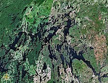
The Kakospictikweak River flows into the Township of Mathieu at the bottom of a bay stretching over 5.8 kilometres (3.6mi), e.g. the Northern part of Omina Lake on the north shore of the [[Gouin Reservoir]]; this bay is barred on the east side by a peninsula stretching southward on 5.6 kilometres (3.5mi) and on the west side by an advanced land to a strait separating it from a large deformed island with a length of 22.9 kilometres (14.2mi). From the mouth of this bay, the current flows south-easterly across the Gouin reservoir to the southeast, skirting several islands and passing through the Kikendatch Bay, up to the Gouin dam. From there, the current flows along the Saint-Maurice River to Trois-Rivières, where it flows into the St. Lawrence River.
This page is based on this Wikipedia article Text is available under the CC BY-SA 4.0 license; additional terms may apply. Images, videos and audio are available under their respective licenses.