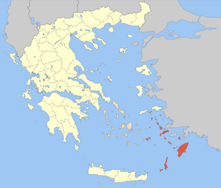
The Dodecanese are a group of 15 larger plus 150 smaller Greek islands in the southeastern Aegean Sea and Eastern Mediterranean, off the coast of Turkey's Anatolia, of which 26 are inhabited. This island group generally defines the eastern limit of the Sea of Crete. They belong to the wider Southern Sporades island group.

Aeaea, Ææa or Eëä was a mythological island said to be the home of the goddess-sorceress Circe. In Homer's Odyssey, Odysseus tells Alcinous that he stayed here for one year on his way home to Ithaca. He says that he could not resist the need to be on this island, not so much for Circe but so that he does not resist the pull. The modern Greek scholar Ioannis Kakridis insists that any attempt at realistic identification is in vain, arguing that Homer vaguely located Aeaea somewhere in the eastern part of his world, perhaps near Colchis, since Circe was the sister of Aeëtes, king of Colchis, and because their paternal aunt the goddess Eos had her palace there.

Archangelos is a town and a former municipality on the island of Rhodes, in the Dodecanese, Greece. Since the 2011 local government reform it is part of the municipality Rhodes, of which it is a municipal unit.

Rhodes is the principal city and a former municipality on the island of Rhodes in the Dodecanese, Greece. Since the 2011 local government reform it is part of the municipality Rhodes, of which it is the seat and a municipal unit. It has a population of approximately 50,000 inhabitants. Rhodes has been famous since antiquity as the site of Colossus of Rhodes, one of the Seven Wonders of the Ancient World. The citadel of Rhodes, built by the Hospitalliers, is one of the best-preserved medieval towns in Europe, which in 1988 was designated as a UNESCO World Heritage Site.

Kremasti is a town on the Greek island of Rhodes. Located on the west coast of the island, Kremasti is 12 kilometers from the capital of Rhodes, on the road to the airport. It has a population of 5,363 people and was the administrative center of the former municipality of Petaloudes.
The Acropolis of Rhodes is an acropolis dating from the Classical Greek period located approximately 3 kilometers from the centre of the city of Rhodes, Rhodes.

Rhodes is the largest of the Dodecanese islands of Greece and is also the island group's historical capital. Administratively the island forms a separate municipality within the Rhodes regional unit, which is part of the South Aegean administrative region. The principal town of the island and seat of the municipality is Rhodes. The city of Rhodes had 50,636 inhabitants in 2011. It is located northeast of Crete, southeast of Athens. Rhodes' nickname is The Island of the Knights, named after the Knights of Saint John of Jerusalem, who ruled the island from 1310 to 1522.

The Battle of Rhodes was fought in May 1912 as part of the Italo-Turkish War. Italian troops under Lieutenant General Giovanni Ameglio landed on the Turkish held island and took control of it after thirteen days of fighting, ending nearly 400 years of Ottoman rule. The battle became the major engagement during the Italian operations in the Aegean Sea.
The Hospitaller conquest of Rhodes took place in 1306–1310. The Knights Hospitaller, led by Grand Master Foulques de Villaret, landed on the island in summer 1306 and quickly conquered most of it except for the city of Rhodes, which remained in Byzantine hands. Emperor Andronikos II Palaiologos sent reinforcements, which allowed the city to repel the initial Hospitaller attacks, and persevere until it was captured on 15 August 1310. The Hospitallers transferred their base to the island, which became the centre of their activities until it was conquered by the Ottoman Empire in 1522.

Stegna is a small village and part of the former municipality of Archangelos on the island of Rhodes, in the Dodecanese, Greece. Since the 2011 local government reform it is part of the municipality of Rhodes.
The geology of Estonia is the study of rocks, minerals, water, landforms and geologic history in Estonia. The crust is part of the East European Craton and formed beginning in the Paleoproterozoic nearly two billion years ago. Shallow marine environments predominated in Estonia, producing extensive natural resources from organic matter such as oil shale and phosphorite. The Mesozoic and much of the Cenozoic are not well-preserved in the rock record, although the glaciations during the Pleistocene buried deep valleys in sediment, rechanneled streams and left a landscape of extensive lakes and peat bogs.
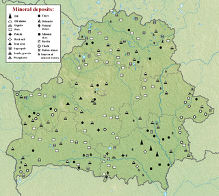
The geology of Belarus began to form more than 2.5 billion years ago in the Precambrian, although many overlying sedimentary units deposited during the Paleozoic and the current Quaternary. Belarus is located in the eastern European plain. From east to west it covers about 650 kilometers while from north to south it covers about 560 kilometers, and the total area is about 207,600 square kilometers. It borders Poland in the north, Lithuania in the northwest, Latvia and Russia in the north, and Ukraine in the south. Belarus has a planar topography with a height of about 160 m above sea level. The highest elevation at 346 meters above sea level is Mt. Dzerzhinskaya, and the lowest point at the height of 80 m is in the Neman River valley.
The geology of Georgia is the study of rocks, minerals, water, landforms and geologic history in Georgia. The country is dominated by the Caucasus Mountains at the junction of the Eurasian Plate and the Afro-Arabian Plate, and rock units from the Mesozoic and Cenozoic are particularly prevalent. For much of its geologic history, until the uplift of the Caucasus, Georgia was submerged by marine transgression events. Geologic research for 150 years by Georgian and Russian geologists has shed significant light on the region and since the 1970s has been augmented with the understanding of plate tectonics.

The geology of Bosnia & Herzegovina is the study of rocks, minerals, water, landforms and geologic history in the country. The oldest rocks exposed at or near the surface date to the Paleozoic and the Precambrian geologic history of the region remains poorly understood. Complex assemblages of flysch, ophiolite, mélange and igneous plutons together with thick sedimentary units are a defining characteristic of the Dinaric Alps, also known as the Dinaride Mountains, which dominate much of the country's landscape.

The geology of Kazakhstan includes extensive basement rocks from the Precambrian and widespread Paleozoic rocks, as well as sediments formed in rift basins during the Mesozoic.
The geology of Kyrgyzstan began to form during the Proterozoic. The country has experienced long-running uplift events, forming the Tian Shan mountains and large, sediment filled basins.
The geology of Thailand includes deep crystalline metamorphic basement rocks, overlain by extensive sandstone, limestone, turbidites and some volcanic rocks. The region experienced complicated tectonics during the Paleozoic, long-running shallow water conditions and then renewed uplift and erosion in the past several million years ago.
The geology of Greece is highly structurally complex due to its position at the junction between the European and African tectonic plates.
The geology of Denmark includes 12 kilometers of unmetamorphosed sediments lie atop the Precambrian Fennoscandian Shield, the Norwegian-Scottish Caledonides and buried North German-Polish Caledonides. The stable Fennoscandian Shield formed from 1.45 billion years ago to 850 million years ago in the Proterozoic. The Fennoscandian Border Zone is a large fault, bounding the deep basement rock of the Danish Basin—a trough between the Border Zone and the Ringkobing-Fyn High. The Sorgenfrei-Tornquist Zone is a fault-bounded area displaying Cretaceous-Cenozoic inversion.

The geology of Italy includes mountain ranges such as the Alps, the Dolomites and the Apennines formed from the uplift of igneous and primarily marine sedimentary rocks all formed since the Paleozoic. Some active volcanoes are located in Insular Italy.
