
Karaikudi is the largest city in Sivaganga district in the Indian state of Tamil Nadu. It is the 21st largest urban agglomeration of Tamil Nadu based on 2011 census data. It is part of the area commonly referred to as "Chettinad" and has been declared a Municipality by the Government of Tamil Nadu, on account of the palatial houses built with limestone called Kaarai veedu. For this reason, the place is sometimes called as Kaarai Nagar locally. The main municipality is spread across 33.75 km2 (13.03 sq mi) and the extended urban limit spreads about 115 km2 (44 sq mi) which undergoes major developments as part of Government Schemes.

Chettinad is a region located mainly in the Sivaganga district historically ruled by Ramnad kingdom of Pandya Nadu and has a small portion extending into the Pudukottai District in Tamil Nadu, India.. Karaikudi is the major town of this area and considered the urban center for Chettinad villages.

Rayavaram is a village Panchayat in Pudukkottai district in Tamil Nadu, India.

Puduvayal is a town in Karaikudi taluk, Sivaganga district in the Indian state of Tamil Nadu. It is a town located in the Chettinad region of the Sivagangai district. On road, it is 12 km away from Karaikudi and 21 km away from Aranthangi. This town is famous for its rice mills. Puduvayal is the 2nd largest rice producer in Tamil Nadu. Puduvayal is an important commercial centre for trade in the Sivaganga district and part of the suburban region of Karaikudi. The town is famous for its Veerasekara Umaiyambigai Temple. Nearby Kandanur is famous for Kandanur Sivan Kovil—which is a replica of the Madurai Meenakshi Temple—built by Nagarthars.
Aranthangi is a town in Pudukkottai district in the state of Tamil Nadu, India. As of 2011, it had a population of 40,814.
Vellakovil is a municipal town in Kangeyam taluk of Tirupur District, in the Indian state of Tamil Nadu. It is located on National Highway 81 between Trichy and Coimbatore. The town is spread in an area of 64.75 km2. As of 2011, the town had a population of 40,359. Kannapuram village located near to this town is famous for Kangeyam breed cattle market that happens on every year during Mariyamman temple festival in the month of April. It is an industrialized town with traditional agriculture being the occupation for most of the people. It holds lot of Power looms weaving bedsheets, floor mats and cotton materials being exported to foreign countries via exporters present in Karur.
Kallur is an Urban Area in Kurnool Municipal Corporation located in Kurnool district of the Indian state of Andhra Pradesh. Western part of Kurnool city is called Kallur. Some main areas in Kurnool city like, Ballari Chowrasta, Chennamma Circle, Birla Compound, APSRTC Main Bus stand comes under Kallur mandal.

A. Durai Arasan was an Indian politician and former Member of the Legislative Assembly of Tamil Nadu. He was elected to the Tamil Nadu legislative assembly as a Dravida Munnetra Kazhagam candidate from Arantangi constituency in 1962, and 1967 elections.
Kundagavayal is a village in the Avadaiyarkoil revenue block of Pudukkottai district, Tamil Nadu, India.
Kongudi is a village in the Aranthangi revenue block of Pudukkottai district, Tamil Nadu, India.
Rajendrapuram is a village in the Aranthangi revenue block of Pudukkottai district, Tamil Nadu, India.

Alampattu is a village in the state of Tamil Nadu, Sivaganga District, India. It is 20 km from the town Karaikudi.
The Manamadurai Junction railway station serves the city of Manamadurai in Tamil Nadu. It belongs to Madurai railway division. It is one of the two major railway junctions within the Sivaganga District; and the other one is Karaikudi Junction which is approximately 60kms north which has four rail branches and a major passenger railhead in the district.
Periyalur is a village in Pudukkottai District in the Indian state of Tamil Nadu. It is populated by approximately one thousand families.

Karaikkudi Junction is one of the major passenger rail head and major junction located in Sivaganga district and serving the city of Karaikudi and surrounding places.
Kalathur.T is a Panchayat village in Karaikudi Assembly, Kannankudi union and Devakottai Taluk of Sivaganga district in the Indian state of Tamil Nadu.

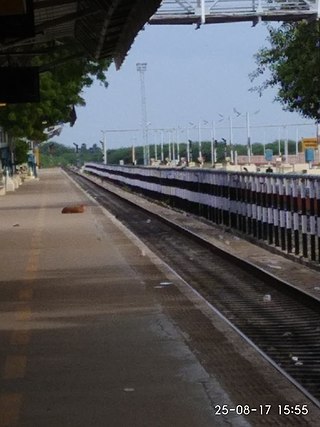
Aranthangi railway station is a railway station serving the town of Aranthangi in Tamil Nadu, India. This station was first opened on 31.12.1903 along with Pattukottai to Aranthangi section before independence. This station located in the thiruvarur -karaikudi section one of the longest stretch in Tiruchirappalli railway division.

Peravurani railway station is a railway station serving the town of Peravurani in Tamil Nadu, India. This station was first opened on 31.12.1903 along with Pattukottai to Aranthangi section before independence. This station located in the thiruvarur -karaikudi section one of the longest stretch in Tiruchirappalli railway division.

Sivaganga railway station serves the city of Sivaganga, India. The station belongs to the Madurai railway division and is a major transit point in Sivagangai district. It is also known by its official code: SVGA. It is under the station category B. It is one of the district headquarters railway station in India.
