Indira Gandhi International Airport is the primary international airport serving Delhi, the capital of India, and the National Capital Region (NCR). The airport, spread over an area of 5,106 acres (2,066 ha), is situated in Palam, Delhi, 15 km (9.3 mi) southwest of the New Delhi Railway Station and 16 km (9.9 mi) from New Delhi city centre. Named after Indira Gandhi (1917–1984), the former Prime Minister of India, it is the busiest airport of India in terms of passenger traffic since 2009. It is also the busiest airport in the country in terms of cargo traffic. In the financial year of 2023-24, the airport handled 7.36 crore passengers, the highest ever in the airport's history. As of 2024, it is the tenth-busiest airport in the world, as per the latest rankings issued by the UK-based air consultancy firm, OAG. It is the second-busiest airport in the world by seating capacity, having a seating capacity of over 36 lakh seats, and the busiest airport in Asia by passenger traffic, handling over 6.55 crore passengers in 2023. In fact, it is routinely one of the busiest airports in the world, according to the Airports Council International rankings.

The Laccadive or Kannur Islands are one of the three island subgroups in the Union Territory of Lakshadweep, India. It is the central subgroup of the Lakshadweep, separated from the Amindivi Islands subgroup roughly by the 11th parallel north and from the atoll of Minicoy (Maliku)—far to the south—by the 9 Degree or Mamala Channel.

Kavaratti is the capital of the Union Territory of Lakshadweep in India. Kavaratti is a census town as well as the name of the atoll upon which the town stands. It is well known for its pristine white sand beaches and calm lagoons, which makes it a popular tourist destination. It is located 332 km (206 mi) west to the city of Kannur, 351 km (218 mi) west of the city of Kozhikode, and 404 km (251 mi) west of the city of Kochi.

Minicoy, locally known as Maliku, is an island in Lakshadweep, India. Along with Viringili, it is on Maliku atoll, the southernmost atoll of Lakshadweep archipelago. Administratively, it is a census town in the Indian union territory of Lakshadweep. The island is situated 425 km west of Trivandrum, the capital city of Kerala.

Agatti Island is a 7.6 km long island, situated on a coral atoll called Agatti atoll in the Union Territory of Lakshadweep, India. It is 459 km (285 mi) west of the city of Kochi.
The Aminidivi Islands are one of the three island subgroups in the Union Territory of Lakshadweep, India. It is the northern group of the Lakshadweep, separated from the Laccadive Islands subgroup roughly by the 11th parallel north. The total land area of the group is 9.26 km2.

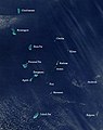
Lakshadweep is a union territory of India. It is an archipelago of 36 islands divided into three island subgroups: the Laccadive Islands in the middle with the Amindivi Islands in the north separated roughly by the 11th parallel north and the atoll of Minicoy to the south separated by the Nine Degree Channel along the 9th parallel north. The islands are sandwiched between the Arabian Sea to the west and the Laccadive Sea to the east with the islands located about 220–440 km (140–270 mi) off the Malabar Coast of mainland India.
Andrott Island, also known as Androth Island, is a small inhabited island in the Union Territory of Lakshadweep, a group of 36 coral islands scattered in the Arabian Sea off the western coast of India. It has a distance of 293 km (182 mi) west of the city of Kochi.
Amini is a census town in the Union Territory of Lakshadweep, India. It is also the name of the island where the town stands and of the atoll that contains that island. It lies 407 km (253 mi) west of the city of Kochi.
Bitra, also known as Bitrā Par, is a coral atoll belonging to the Amindivi Subgroup of islands of the Union Territory of Lakshadweep in India. It is 483 km (300 mi) west of the city of Kochi.

Kalpeni is an inhabited Atoll in the Union Territory of Lakshadweep, India. It has a distance of 287 km (178 mi) west of the city of Kochi.

Prayagraj Airport, also known as Allahabad Airport, is the domestic airport serving the city of Prayagraj, Uttar Pradesh, India. Located in the Bamrauli suburb of the city, it is one of the oldest airports in India. This airport is currently under joint operation of the Indian Air Force and the Airports Authority of India. It is the third busiest airport in Uttar Pradesh after Lucknow International Airport and Varanasi International Airport in terms of passenger traffic and aircraft movements.
Agatti Airport is a regional airport serving the union territory of Lakshadweep, India. It is located at the southern end of Agatti Island, and is the sole airstrip in the archipelago, which lies off the west coast of mainland India.
Bassas de Pedro, also known as Manjappar or Pedro Bank, is a submerged bank or sunken atoll belonging to the Amindivi Subgroup of islands of the Union Territory of Lakshadweep, India, with a distance of 1,795 km (1,115 mi) south of the city of Delhi.0
Chetlat Island is a coral island belonging to the Amindivi Subgroup of islands of the Lakshadweep archipelago in India. It has a distance of 432 km (268 mi) west of the city of Kochi.
Cherbaniani Reef, also known as Beleapani Reef, is a coral atoll belonging to the Amindivi Subgroup of islands of the Union Territory of Lakshadweep, India. It has a distance of 1,880 km (1,170 mi) south of the city of Delhi.
Bangaram is an atoll in the Union Territory of Lakshadweep, India.
Suheli Par is a coral atoll in the Union Territory of Lakshadweep, India. It is an oval-shaped 17 km long atoll surrounded by a zone of rich marine fauna.
Pitti, also known as Pakshipitti, is an uninhabited coral islet in the Union Territory of Lakshadweep, India.