
The Eastern Railway is among the 19 zones of the Indian Railways. Its headquarters is at Fairley Place, Kolkata and comprises four divisions: Howrah, Malda, Sealdah, and Asansol. Each division is headed by a Divisional Railway Manager (DRM). The name of the division denotes the name of the city where the divisional headquarters is located. Eastern Railway oversees the largest and second largest rail complexes in the country, Howrah Junction and Sealdah railway station, and also contains the highest number of A1 and A Category Stations like Howrah, Malda Town, Sealdah, Asansol, Kolkata, Durgapur, Barddhaman, Rampurhat Junction, Bhagalpur,Jamalpur, Jasidih, Bandel and Naihati. Eastern Railways operates India's oldest train, Kalka Mail.
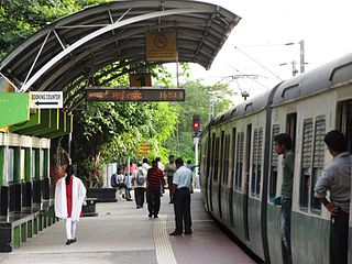
The Kolkata Suburban Railway is a set of suburban and regional rail services serving the Kolkata metropolitan area and its surroundings in India. It is the largest suburban railway network in the country by number of stations and track length, and also one of the largest in the world. There are five main lines and nineteen branch lines. It operates more than 1,500 services, carrying 3.5 million people daily and 1.2 billion people every year. It runs from 03:00 am until 02:00 am and fares range from Rs.5 to Rs.25. The system uses 25 kV 50 Hz AC power supply and runs on 5 ft 6 in broad gauge track. It has interchange stations with the Kolkata Metro at various locations.
Begampur is a census town in Chanditala II CD Block in Srirampore subdivision of Hooghly district in the state of West Bengal, India.

Bally is a neighbourhood in the city of Howrah of Howrah district in the Indian state of West Bengal. It is a part of the area covered by Kolkata Metropolitan Development Authority (KMDA).
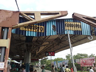
Kamarkundu is a railway station at the crossing of the Howrah–Bishnupur and the Howrah–Bardhaman chord lines. It serves Kamarkundu in Hooghly district in the Indian state of West Bengal.

Singur is a community development block that forms an administrative division in Chandannagore subdivision of Hooghly district in the Indian state of West Bengal.

The Howrah–New Delhi main line is a railway line connecting Delhi and Kolkata cutting across northern India. The 1,531 km (951 mi) railway line was opened to traffic in 1866 with the introduction of the "1 Down/2 Up Mail" train.
The Howrah–Barddhaman chord line is a broad-gauge rail line connecting Howrah and Bardhaman. The 95-kilometre-long (59 mi) railway line operates in Howrah, Hooghly and Purba Bardhaman districts in the state of West Bengal. It is part of the Howrah–Gaya–Delhi line,Howrah–Delhi main line,Howrah–Prayagraj–Mumbai line and the Kolkata Suburban Railway system.

Saktigarh is a Kolkata Suburban Railway junction station on the Howrah–Bardhaman main line and Howrah–Bardhaman chord. It is located in Purba Bardhaman district in the Indian state of West Bengal. It serves Saktigarh and surrounding areas.

Baruipara is a census town in Singur CD block in Chandannagore subdivision of Hooghly district in the state of West Bengal, India.
Adan is a village in Chanditala II community development block of Srirampore subdivision in Hooghly district in the Indian state of West Bengal.
Bamandanga is a village in Chanditala II community development block of Srirampore subdivision in Hooghly district in the Indian state of West Bengal.
Bankagachha is a village in Chanditala II community development block of Srirampore subdivision in Hooghly district in the Indian state of West Bengal.
Benipur is a village in Chanditala II community development block of Srirampore subdivision in Hooghly district in the Indian state of West Bengal.
Duttapur is a village in Chanditala II community development block of Srirampore subdivision in Hooghly district in the Indian state of West Bengal.
Madhabpur is a village in Chanditala II community development block of Srirampore subdivision in Hooghly district in the Indian state of West Bengal.
Sahana is a village in Chanditala II community development block of Srirampore subdivision in Hooghly district in the Indian state of West Bengal.
Sanka is a village in Chanditala II community development block of Srirampore subdivision in Hooghly district in the Indian state of West Bengal.
Thero is a village in Chanditala II community development block of Srirampore subdivision in Hooghly district in the Indian state of West Bengal.
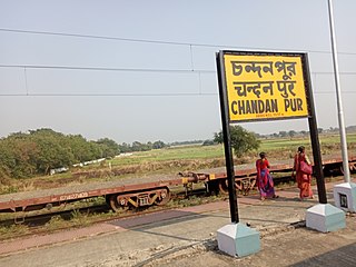
Chandanpur railway station is a Kolkata Suburban Railway station on the Howrah–Bardhaman chord line operated by Eastern Railway zone of Indian Railways. It is situated beside State Highway 2, Chandanpur in Hooghly district in the Indian state of West Bengal. A number of EMU trains stop at this station.

