Kampinos is a village in Warsaw West County, Masovian Voivodeship, in east-central Poland. It is the seat of the gmina called Gmina Kampinos. It lies approximately 8 kilometres (5 mi) east of Sochaczew and 38 km (24 mi) west of Warsaw.

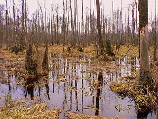
Kampinos National Park is a national park in east-central Poland, in Masovian Voivodeship, on the northwest outskirts of Warsaw. It is Poland's second-largest national park by area and the only national park in the Masovian Voivodeship. It has a sister park agreement with Indiana Dunes National Park, Indiana, United States.
Gmina Kampinos is a rural gmina in Warsaw West County, Masovian Voivodeship, in east-central Poland. Its seat is the village of Kampinos, which lies approximately 25 kilometres (16 mi) west of Ożarów Mazowiecki and 38 km (24 mi) west of Warsaw.
Izabelin is a settlement in the administrative district of Gmina Juchnowiec Kościelny, within Białystok County, Podlaskie Voivodeship, in north-eastern Poland.
Budki Żelazowskie is a village in the administrative district of Gmina Kampinos, within Warsaw West County, Masovian Voivodeship, in east-central Poland. It lies approximately 9 kilometres (6 mi) west of Kampinos, 34 km (21 mi) west of Ożarów Mazowiecki, and 47 km (29 mi) west of Warsaw.
Grabnik is a village in the administrative district of Gmina Kampinos, within Warsaw West County, Masovian Voivodeship, in east-central Poland. It lies approximately 3 kilometres (2 mi) north-west of Kampinos, 28 km (17 mi) west of Ożarów Mazowiecki, and 41 km (25 mi) west of Warsaw.
Granica is a village in the administrative district of Gmina Kampinos, within Warsaw West County, Masovian Voivodeship, in east-central Poland. It lies approximately 3 kilometres (2 mi) north-west of Kampinos, 27 km (17 mi) west of Ożarów Mazowiecki, and 40 km (25 mi) west of Warsaw.
Józefów is a village in the administrative district of Gmina Kampinos, within Warsaw West County, Masovian Voivodeship, in east-central Poland. It lies approximately 3 kilometres (2 mi) north-east of Kampinos, 24 km (15 mi) west of Ożarów Mazowiecki, and 37 km (23 mi) west of Warsaw.
Kirsztajnów is a village in the administrative district of Gmina Kampinos, within Warsaw West County, Masovian Voivodeship, in east-central Poland. It lies approximately 10 kilometres (6 mi) west of Kampinos, 34 km (21 mi) west of Ożarów Mazowiecki, and 47 km (29 mi) west of Warsaw.
Komorów is a village in the administrative district of Gmina Kampinos, within Warsaw West County, Masovian Voivodeship, in east-central Poland. It lies approximately 2 kilometres (1 mi) west of Kampinos, 26 km (16 mi) west of Ożarów Mazowiecki, and 40 km (25 mi) west of Warsaw.
Koszówka is a village in the administrative district of Gmina Kampinos, within Warsaw West County, Masovian Voivodeship, in east-central Poland. It lies approximately 2 kilometres (1 mi) east of Kampinos, 24 km (15 mi) west of Ożarów Mazowiecki, and 37 km (23 mi) west of Warsaw.
Łazy is a village in the administrative district of Gmina Kampinos, within Warsaw West County, Masovian Voivodeship, in east-central Poland. It lies approximately 4 kilometres (2 mi) west of Kampinos, 28 km (17 mi) west of Ożarów Mazowiecki, and 42 km (26 mi) west of Warsaw.
Pindal is a village in the administrative district of Gmina Kampinos, within Warsaw West County, Masovian Voivodeship, in east-central Poland. It lies approximately 7 kilometres (4 mi) west of Kampinos, 31 km (19 mi) west of Ożarów Mazowiecki, and 45 km (28 mi) west of Warsaw.
Prusy is a village in the administrative district of Gmina Kampinos, within Warsaw West County, Masovian Voivodeship, in east-central Poland. It lies approximately 2 kilometres (1 mi) south of Kampinos, 25 km (16 mi) west of Ożarów Mazowiecki, and 38 km (24 mi) west of Warsaw.
Rzęszyce is a village in the administrative district of Gmina Kampinos, within Warsaw West County, Masovian Voivodeship, in east-central Poland. It lies approximately 7 kilometres (4 mi) west of Kampinos, 31 km (19 mi) west of Ożarów Mazowiecki, and 45 km (28 mi) west of Warsaw.
Szczytno is a village in the administrative district of Gmina Kampinos, within Warsaw West County, Masovian Voivodeship, in east-central Poland. It lies approximately 8 kilometres (5 mi) west of Kampinos, 31 km (19 mi) west of Ożarów Mazowiecki, and 45 km (28 mi) west of Warsaw.

Wiejca is a village in the administrative district of Gmina Kampinos, within Warsaw West County, Masovian Voivodeship, in east-central Poland. It lies approximately 4 kilometres (2 mi) east of Kampinos, 22 km (14 mi) west of Ożarów Mazowiecki, and 35 km (22 mi) west of Warsaw.
Wola Pasikońska is a village in the administrative district of Gmina Kampinos, inside Warsaw West County, Masovian Voivodeship, in east-central Poland. It is located approximately 6 kilometres (4 mi) west of Kampinos, 30 km (19 mi) west of Ożarów Mazowiecki, and 44 km (27 mi) west of Warsaw.
Zawady is a village in the administrative district of Gmina Kampinos, within Warsaw West County, Masovian Voivodeship, in east-central Poland. It lies approximately 3 kilometres (2 mi) south-west of Kampinos, 27 km (17 mi) west of Ożarów Mazowiecki, and 40 km (25 mi) west of Warsaw.

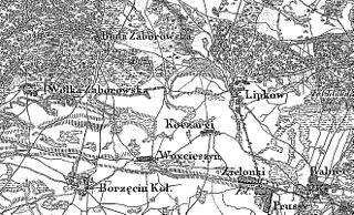
The Battle of Buda Zaborowska, one of many skirmishes of the January Uprising, took place on 14 April 1863 near the village of Buda Zaborowska in central part of Russian-controlled Congress Poland. Polish forces under Major Walery Remiszewski clashed with troops of the Imperial Russian Army. The battle resulted in Russian victory.


