
Kampinos is a village in Warsaw West County, Masovian Voivodeship, in east-central Poland. It is the seat of the gmina called Gmina Kampinos. It lies approximately 8 kilometres (5 mi) east of Sochaczew and 38 km (24 mi) west of Warsaw.
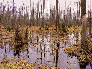
Kampinos National Park is a National Park in east-central Poland, in Masovian Voivodeship, on the north-west outskirts of Warsaw. It has a sister park agreement with Indiana Dunes National Park, Indiana, United States.
Hołubla is a village in the administrative district of Gmina Paprotnia, within Siedlce County, Masovian Voivodeship, in east-central Poland. It lies approximately 18 kilometres (11 mi) north-east of Siedlce and 98 km (61 mi) east of Warsaw.
Budki Żelazowskie is a village in the administrative district of Gmina Kampinos, within Warsaw West County, Masovian Voivodeship, in east-central Poland. It lies approximately 9 kilometres (6 mi) west of Kampinos, 34 km (21 mi) west of Ożarów Mazowiecki, and 47 km (29 mi) west of Warsaw.
Grabnik is a village in the administrative district of Gmina Kampinos, within Warsaw West County, Masovian Voivodeship, in east-central Poland. It lies approximately 3 kilometres (2 mi) north-west of Kampinos, 28 km (17 mi) west of Ożarów Mazowiecki, and 41 km (25 mi) west of Warsaw.
Józefów is a village in the administrative district of Gmina Kampinos, within Warsaw West County, Masovian Voivodeship, in east-central Poland. It lies approximately 3 kilometres (2 mi) north-east of Kampinos, 24 km (15 mi) west of Ożarów Mazowiecki, and 37 km (23 mi) west of Warsaw.
Kirsztajnów is a village in the administrative district of Gmina Kampinos, within Warsaw West County, Masovian Voivodeship, in east-central Poland. It lies approximately 10 kilometres (6 mi) west of Kampinos, 34 km (21 mi) west of Ożarów Mazowiecki, and 47 km (29 mi) west of Warsaw.
Komorów is a village in the administrative district of Gmina Kampinos, within Warsaw West County, Masovian Voivodeship, in east-central Poland. It lies approximately 2 kilometres (1 mi) west of Kampinos, 26 km (16 mi) west of Ożarów Mazowiecki, and 40 km (25 mi) west of Warsaw.
Koszówka is a village in the administrative district of Gmina Kampinos, within Warsaw West County, Masovian Voivodeship, in east-central Poland. It lies approximately 2 kilometres (1 mi) east of Kampinos, 24 km (15 mi) west of Ożarów Mazowiecki, and 37 km (23 mi) west of Warsaw.
Łazy is a village in the administrative district of Gmina Kampinos, within Warsaw West County, Masovian Voivodeship, in east-central Poland. It lies approximately 4 kilometres (2 mi) west of Kampinos, 28 km (17 mi) west of Ożarów Mazowiecki, and 42 km (26 mi) west of Warsaw.
Łazy Leśne is a village in the administrative district of Gmina Kampinos, within Warsaw West County, Masovian Voivodeship, in east-central Poland. It lies approximately 4 kilometres (2 mi) north-west of Kampinos, 28 km (17 mi) west of Ożarów Mazowiecki, and 41 km (25 mi) west of Warsaw.
Pindal is a village in the administrative district of Gmina Kampinos, within Warsaw West County, Masovian Voivodeship, in east-central Poland. It lies approximately 7 kilometres (4 mi) west of Kampinos, 31 km (19 mi) west of Ożarów Mazowiecki, and 45 km (28 mi) west of Warsaw.
Prusy is a village in the administrative district of Gmina Kampinos, within Warsaw West County, Masovian Voivodeship, in east-central Poland. It lies approximately 2 kilometres (1 mi) south of Kampinos, 25 km (16 mi) west of Ożarów Mazowiecki, and 38 km (24 mi) west of Warsaw.
Rzęszyce is a village in the administrative district of Gmina Kampinos, within Warsaw West County, Masovian Voivodeship, in east-central Poland. It lies approximately 7 kilometres (4 mi) west of Kampinos, 31 km (19 mi) west of Ożarów Mazowiecki, and 45 km (28 mi) west of Warsaw.
Stare Gnatowice is a village in the administrative district of Gmina Kampinos, within Warsaw West County, Masovian Voivodeship, in eastcentral Poland. It lies approximately 5 kilometres (3 mi) south-west of Kampinos, 26 km (16 mi) west of Ożarów Mazowiecki, and 40 km (25 mi) west of Warsaw.
Szczytno is a village in the administrative district of Gmina Kampinos, within Warsaw West County, Masovian Voivodeship, in east-central Poland. It lies approximately 8 kilometres (5 mi) west of Kampinos, 31 km (19 mi) west of Ożarów Mazowiecki, and 45 km (28 mi) west of Warsaw.
Wiejca is a village in the administrative district of Gmina Kampinos, within Warsaw West County, Masovian Voivodeship, in east-central Poland. It lies approximately 4 kilometres (2 mi) east of Kampinos, 22 km (14 mi) west of Ożarów Mazowiecki, and 35 km (22 mi) west of Warsaw.
Wola Pasikońska is a village in the administrative district of Gmina Kampinos,inside Warsaw West County, Masovian Voivodeship, in east-central Poland. It is located approximately 6 kilometres (4 mi) west of Kampinos, 30 km (19 mi) west of Ożarów Mazowiecki, and 44 km (27 mi) west of Warsaw.
Zawady is a village in the administrative district of Gmina Kampinos, within Warsaw West County, Masovian Voivodeship, in east-central Poland. It lies approximately 3 kilometres (2 mi) south-west of Kampinos, 27 km (17 mi) west of Ożarów Mazowiecki, and 40 km (25 mi) west of Warsaw.


