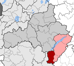
Sapes is a town and a former municipality in the Rhodope regional unit, East Macedonia and Thrace, Greece. Since the 2011 local government reform it is part of the municipality Maroneia-Sapes, of which it is the seat and a municipal unit. The municipal unit has an area of 354.596 km2. The population is 8,383 (2011).
Ventzio is a municipal unit of the Grevena municipality. Before the 2011 local government reform it was an independent municipality. The 2011 census recorded 1,969 residents in the municipal unit. Theodoros Ziakas covers an area of 323.277 km2. The seat of the municipality was in Knidi.
Gorgiani is a municipal unit of the Grevena municipality. Before the 2011 local government reform it was a municipality of its own. The 2011 census recorded 885 residents in the municipal unit. Gorgiani covers an area of 204.555 km2. The seat of the municipality was in Kipoureio.
Irakleotes is a municipal unit of the Grevena municipality. Before the 2011 local government reform, it was an independent municipality. The seat of the municipality was in Agios Georgios. The 2011 census recorded 1,890 residents in the municipal unit. Irakleotes covers an area of 136.631 km2.
Theodoros Ziakas is a municipal unit of the Grevena municipality. Before the 2011 local government reform it was an independent municipality. The 2011 census recorded 1,297 residents in the municipal unit. Theodoros Ziakas covers an area of 241.768 km2. The seat of the municipality was in Mavranaioi.
Temenos is a former municipality in the Heraklion Regional Unit, Crete, Greece. Since the 2011 local government reform it is part of the municipality Heraklion, of which it is a municipal unit. The municipal unit has an area of 56.608 km2. Population 3,260 (2011). The seat of the municipality was in Profitis Ilias.
Kallindoia is a former municipality in the Thessaloniki regional unit, Greece. Since the 2011 local government reform it is part of the municipality Lagkadas, of which it is a municipal unit. The 2011 census recorded 3,592 inhabitants in the municipal unit. The municipal unit of Kallindoia covers an area of 154.748 km2. The seat of the municipality was in Zagliveri.

Langadas is a large town and municipality in the northeast part of Thessaloniki regional unit, Greece. Population 19,587 (2011).

Pangaio is a municipality in the Kavala regional unit, Greece, named after the Pangaion hills. The seat of the municipality is in Eleftheroupoli.
Askio is a former municipality in Kozani regional unit, West Macedonia, Greece. Since the 2011 local government reform it is part of the municipality Voio, of which it is a municipal unit. The municipal unit has an area of 196.636 km2. The 2011 census recorde 4,002 residents in Askio. The seat of the municipality was in Kaloneri. It was named after the Askio mountain range which covers most of the municipal unit.
Ellispontos is a former municipality in Kozani regional unit, West Macedonia, Greece. Since the 2011 local government reform it is part of the municipality Kozani, of which it is a municipal unit. The 2011 census recorded 5,834 residents in the municipal unit. The seat of the municipality was in Koilada. The municipal unit of Ellispontos covers an area of 337.992 km2.
Antichasia is a municipal unit of the Elassona municipality. Before the 2011 local government reform it was an independent municipality. The seat of the municipality was in Krania. The 2011 census recorded 3,584 residents in Atichasia. The municipal unit covers an area of 142.919 km2. Its name comes from the nearby Antichasia mountain.

Visaltia is a municipality in the Serres regional unit, Greece. The seat of the municipality is in Nigrita. It was named after the ancient region Bisaltia. The ancient city of Berge is located here.

Gortynia is a municipality in the Arcadia regional unit, Peloponnese, Greece. The seat of the municipality is the town Dimitsana. The municipality has an area of 1,050.882 km2.

Pogoni is a municipality in the Ioannina regional unit, Epirus, Greece. The seat of the municipality is the village Kalpaki. The municipality has an area of 701.059 km2. Its population was 8,960 at the 2011 census.

Paionia is a municipality in the Kilkis regional unit of Central Macedonia, Greece. The seat of the municipality is the town Polykastro. The municipality is named after the ancient region of Paeonia. It has an area of 919.276 km2.
Malevizi is a municipality in Heraklion regional unit, Crete, Greece. The seat of the municipality is the village Gazi. The municipality has an area of 291.907 km2 (112.706 sq mi).

Amari is a village and a municipality in Rethymno regional unit, Crete, Greece. The seat of the municipality is the village Agia Foteini. The municipal unit has an area of 277.285 km2 (107.060 sq mi). One of the major geographic features of Amari is the Amari Valley, a landform of high elevation known for olive cultivation. It is thought that Monastiraki was developed by Phaistos inhabitants founding a satellite center as they pushed out into the Amari Valley.
Mylopotamos is a municipality in Rethymno regional unit, on Crete, southern Greece. The seat of the municipality is the village Perama. The municipal unit has an area of 360.703 km2 (139.268 sq mi).

Voio is a municipality in the Kozani regional unit, Greece. The seat of the municipality is the town Siatista. It was named after the Voio mountains. The municipality has an area of 1007.629 km2. Its population at the 2011 census was 18,386.