Kanaka Bar

Last updated

Kanaka Bar is an unincorporated community and locality in the Fraser Canyon region of British Columbia, Canada, located near the town of Lytton. Named for a gold-bearing bar on the Fraser River below, which was mined by Hawaiians (called "Kanakas" in the argot of the time), Kanaka Bar is the home of the office and main rancherie of the Kanaka Bar Indian Band of the Nlaka'pamux peoples, and is also the source of the name of Kanaka Bar Indian Reserve No. 1A and Kanaka Bar Indian Reserve No. 2 which are governed by the band.

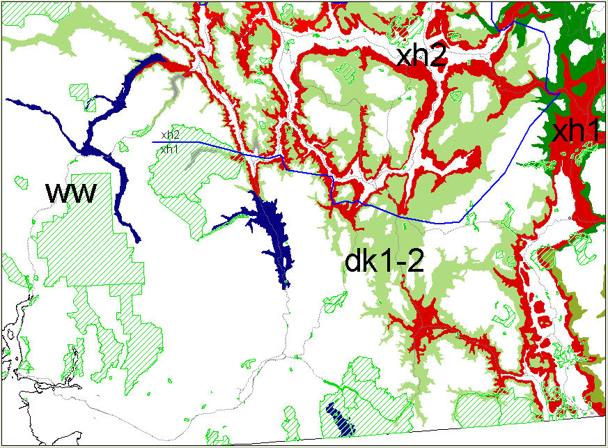
The community lies within the Interior Douglas-Fir (IDF) Biogeoclimatic Zone and is on the boundary between "very dry hot" (IDFxh1) and "wet warm" (IDFww) variants, an early stage of a transition from interior to coastal ecotypes that is seen as one travels south in the Fraser Canyon from Lytton to Hope. [1]

See also

Related Research Articles

Cameron Bar Indian Reserve No. 13, referred to as Cameron Bar 13 for census purposes, is an Indian reserve in the Fraser Canyon region of the Canadian province of British Columbia. As of 2001, the population was 0. The area of the reserve was .35 square kilometres. It is under the administration of the Lytton First Nation based in nearby Lytton, 15 miles to the south, which is a band government of the Nlaka'pamux people.

Lytton, British Columbia Village in British Columbia, Canada

Lytton is a village of about 250 residents in southern British Columbia, Canada on the east side of the Fraser River and primarily the south side of the Thompson River where it flows southwesterly into the Fraser. The community includes the Village of Lytton and the surrounding community of the Lytton First Nation, whose name for the place is Camchin, also spelled Kumsheen.

Spuzzum

Spuzzum is an unincorporated settlement in British Columbia, Canada. Because it is on the Trans-Canada Highway, approximately 50 kilometres (31 mi) north of the community of Hope, it is often referred to as being "beyond Hope".

Marble Canyon (British Columbia)

Marble Canyon is in the south-central Interior of British Columbia, a few kilometres east of the Fraser River and the community of Pavilion, midway between the towns of Lillooet and Cache Creek. The canyon stems from a collapsed karst formation.

Camchin, also spelled Kumsheen, is an anglicization of the ancient name for the locality and aboriginal village once located on the site of today's Village of Lytton, British Columbia, Canada, whose name in the Nlaka'pamux language is ƛ'q'əmcín It also refers to the main Indian reserve community of the Lytton First Nation adjacent to the Village of Lytton and is found in the form Kumsheen in local business and school names.

Boston Bar, British Columbia Unincorporated place in British Columbia, Canada

Boston Bar is an unincorporated community in the Fraser Canyon of the Canadian province of British Columbia.

Bonaparte Indian Band

The Bonaparte Indian Band a.k.a. Bonaparte First Nation, is a member band of the Shuswap Nation Tribal Council of the Secwepemc (Shuswap) people.

Stswecemc Xgattem First Nation First Nation government in British Columbia, Canada

The Stswecem'c Xgat'tem First Nation, formerly known as Canoe Creek Band/Dog Creek Indian Band, created as a result of merger of the Canoe Creek Band and Dog Creek Band is a First Nations government of the Secwepemc (Shuswap) Nation, located in the Fraser Canyon-Cariboo region of the Central Interior of the Canadian province of British Columbia. It was created when the government of the then-Colony of British Columbia established an Indian reserve system in the 1860s. It is a member government of the Northern Shuswap Tribal Council.

The High Bar First Nation is a First Nations government of the Secwepemc (Shuswap) Nation, located in the Fraser Canyon-Cariboo region of the Central Interior of the Canadian province of British Columbia. It was created when the government of the then-Colony of British Columbia established an Indian reserve system in the 1860s. It is one of three Secwepemc bands that is not a member of either the Shuswap Nation Tribal Council or the Northern Shuswap Tribal Council. The High Bar people are also partly Tsilhqot'in and have links with some Chilcotin First Nations.

The Ashcroft First Nation is a First Nations government Thompson Canyon area of the Central Interior of the Canadian province of British Columbia. Its Indian Reserves are located near the town of Ashcroft, British Columbia, it is a member of the Nlaka'pamux Nation Tribal Council.

The Fraser Canyon Indian Administration is a First Nations tribal council government composed of five bands in the Fraser Canyon and Thompson Canyon areas of the Canadian province of British Columbia.

Kanaka Bar First Nation is a First Nations government located at Kanaka Bar, British Columbia, Canada, between the towns of Boston Bar and Lytton in the Fraser Canyon region. It is a member of the Fraser Canyon Indian Administration, one of three tribal councils of the Nlaka'pamux people. Other members of the Fraser Canyon Indian Administration are the Spuzzum, Skuppah and Nicomen First Nations . . Other Nlaka'pamux governments belong either to the Nicola Tribal Association or the Nlaka'pamux Nation Tribal Council.

The Lytton First Nation, a First Nations band government, has its headquarters at Lytton in the Fraser Canyon region of the Canadian province of British Columbia. While it is the largest of all Nlaka'pamux bands, unlike all other governments of the Nlaka'pamux (Thompson) people, it is not a member of any of the three Nlaka'pamux tribal councils, which are the Nicola Tribal Association, the Fraser Canyon Indian Administration and the Nlaka'pamux Nation Tribal Council.

Seton Lake First Nation

The Seton Lake First Nation, a.k.a. the Seton Lake Indian Band, is a First Nations government located in the Central Interior-Fraser Canyon region of the Canadian province of British Columbia. It is a member of the Lillooet Tribal Council, which is the largest grouping of band governments of the St'at'imc people. Other St'at'imc governments include the smaller In-SHUCK-ch Nation on the lower Lillooet River to the southwest, and the independent N'quatqua First Nation at the farther end of Anderson Lake from Seton Portage, which is the location of three of the band's reserve communities.

Fountain, British Columbia

Fountain is an unincorporated rural area and Indian reserve community in the Fraser Canyon region of British Columbia, Canada, located at the ten-mile (16 km) mark from the town of Lillooet on BC Highway 99, which in that area is also on the route of the Old Cariboo Road and is located at the junction of that route with the old gold rush-era trail via Fountain Valley and the Fountain Lakes.

Foster Bar, originally known as Foster's Bar, is a gold-bearing sandbar in the Fraser Canyon of British Columbia, Canada as well as the name used for the surrounding locality, which includes Nesikep Indian Reserve 6 and Nesikep Indian Reserve 6A of the Cayoose Creek First Nation of the St'at'imc people and Lytton Indian Reserves Nos. 6A and 5B and Seah Indian Reserve No. 5 of the Lytton First Nation of the Nlaka'pamux people.

Siska, British Columbia

Siska, also known historically as Cisco, is a locality in the Fraser Canyon of British Columbia, Canada 9.4 kilometres south of the town of Lytton. It is at Siska that the Canadian Pacific and Canadian National Railways switch from one side of the river to the other, due to the impossibility of both railways occupying the same bank of the Fraser due to the narrow and steep terrain. The resulting pair of bridges, with the CNR bridge just upstream of the CPR's, and the CPR's bridge's west foot entering the Cantilever Bar Tunnel into the side of Cisco Bluff, remains one of the most famous images of the CPR's route through British Columbia today and is easily viewable from the adjacent Trans-Canada Highway.

Marble Canyon 3, properly and most commonly referred to as Marble Canyon Indian Reserve No. 3, is an Indian reserve of the Ts’kw’aylaxw First Nation, located at the southeast end of Marble Canyon, adjacent to BC Highway 99 just northwest of the Upper Hat Creek junction, which is about midway between the towns of Lillooet and Cache Creek. The main reserve of the Tx'kw'ylaxw/Pavilion Band is Pavilion Indian Reserve No. 1, located at the community of Pavilion, which lies at the northwest end of Marble Canyon, which is to say at the opening of the valley of Pavilion Creek into the Fraser Canyon.

Nesikep is an unincorporated settlement in British Columbia, Canada, located at the mouth of Nesikep Creek in the Fraser Canyon, to the south of Lillooet and southeast of Texas Creek. It is primarily defined by Nesikep Indian Reserve No. 6 and Nesikep Indian Reserve No. 6A. Nesikep Indian Reserve No. 6 flanks both sides of the Fraser, though the community is only on the right (west) bank.

Nlakapamux Ethnic group of British Columbia

The Nlaka'pamux or Nlakapamuk, also previously known as the Thompson, Thompson River Salish, Thompson Salish, Thompson River Indians or Thompson River people, and historically as the Klackarpun, Haukamaugh, Knife Indians, and Couteau Indians, are an Indigenous First Nations people of the Interior Salish language group in southern British Columbia. Their traditional territory includes parts of the North Cascades region of Washington.

References

Coordinates: 50°07′N121°34′W / 50.117°N 121.567°W / 50.117; -121.567