Kandalama | |
|---|---|
Village | |
 | |
 | |
| Coordinates: 7°53′42″N80°42′21″E / 7.895008°N 80.705695°E | |
| Country | Sri Lanka |
| Province | Central Province |
| District | Matale District |
| Time zone | UTC+5:30 (Sri Lanka Standard Time) |
| Area code | 066 |
Kandalama is a village in the Central Province of Sri Lanka. Kandalama is situated close to two UNESCO World Heritage Sites - the Dambulla cave temple and the Sigiriya rock fortress. [1]
Contents
Kandalama is also home to the Kaludiya Pokuna Archeological Forest and the Heritance Kandalama, one of Sri Lanka's first five-star hotels designed by Geoffrey Bawa.
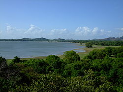
The ancient irrigation tank built 1700 years ago by King Vasabha is situated in Kandalama. Nestling at the foot of Ereulagala (696 m (2,283 ft) above MSL) and Dikkandahena (618 m (2,028 ft) above MSL), the village is situated at the northern end of the Matale hills, and the beginning of the dry plains. The village lies on the border of the intermediate and dry zones of Sri Lanka.
 Kaludiya Pokuna Forest at Kandalama
 Kandalama forest in at Kaludiya Pokuna

