
Acarnania is a region of west-central Greece that lies along the Ionian Sea, west of Aetolia, with the Achelous River for a boundary, and north of the gulf of Calydon, which is the entrance to the Gulf of Corinth. Today it forms the western part of the regional unit of Aetolia-Acarnania. The capital and principal city in ancient times was Stratos. The north side of Acarnania of the Corinthian Gulf was considered part of the region of Epirus.

Continental Greece, colloquially known as Roúmeli (Ρούμελη), is a traditional geographic region of Greece. In English, the area is usually called Central Greece, but the equivalent Greek term is more rarely used.

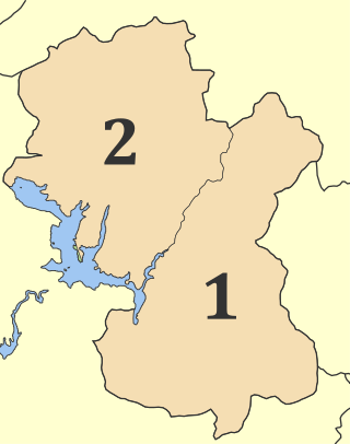
Aetolia-Acarnania is one of the regional units of Greece. It is part of the geographic region of Central Greece and the administrative region of West Greece. A combination of the historical regions of Aetolia and Acarnania, it is the country's largest regional unit. Its capital is Missolonghi for historical reasons, with its biggest city and economic centre at Agrinio. The area is now connected with the Peloponnese peninsula via the Rio-Antirio Bridge. The surrounding regional units take in Arta in Epirus, a narrow length bordering Karditsa of Thessaly, Evrytania to the northeast, and Phocis to the east.
Evrytania is one of the regional units of Greece. It is part of the region of Central Greece. Its capital is Karpenisi.
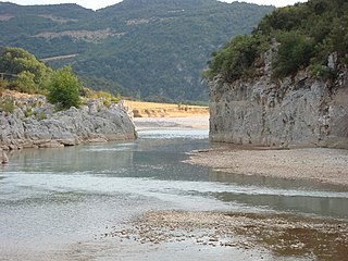
The Achelous, also Acheloos, is a river in Epirus, western Greece. It is 220 km (137 mi) long. It formed the boundary between Acarnania and Aetolia of antiquity. It empties into the Ionian Sea. In ancient times its spirit was venerated as the river god Achelous.

Agrinio is the largest city of the Aetolia-Acarnania regional unit of Greece and its largest municipality, with 89,691 inhabitants (2021). It is the economic center of Aetolia-Acarnania, although its capital is the town of Mesolonghi. The settlement dates back to ancient times. Ancient Agrinion was 3 kilometres northeast of the present city; some walls and foundations of which have been excavated. In medieval times and until 1836, the city was known as Vrachori (Βραχώρι).
Antirrio is a town and a former municipality in Aetolia-Acarnania, West Greece, Greece. Since the 2011 local government reform it is part of the municipality Nafpaktia, of which it is a municipal unit. The municipal unit has an area of 50.794 km2.

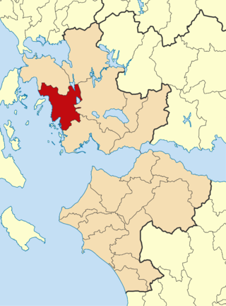
Astakos is a town and a former municipality in Aetolia-Acarnania, West Greece, Greece. Since the 2011 local government reform it is part of the municipality Xiromero, of which it is a municipal unit. The municipal unit has an area of 345.099 km2. It is located on a bay on the eastern shore of the Ionian Sea, near the southern end of the Acarnanian Mountains. It takes its name from the ancient Acarnanian town Astacus, and was named Dragamesti in the Middle Ages. It is speculated to be the site of ancient Dulichium.

National Road 38 is a single carriageway road in western and central Greece. It connects Thermo with Lamia, via Agrinio and Karpenisi. It passes through the regional units Aetolia-Acarnania, Evrytania and Phthiotis. One section coincides with the European route E952. The E962 goes between Agrinio and Lamia.
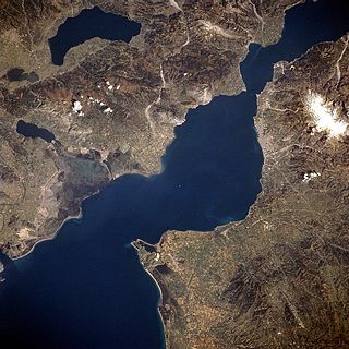
The Gulf of Patras is a branch of the Ionian Sea in Western Greece. On the east, it is closed by the Strait of Rion between capes Rio and Antirrio, near the Rio-Antirrio bridge, that is the entrance of the Gulf of Corinth. On the west, it is bounded by a line from Oxeia island to Cape Araxos. To the north it is bounded by the shore of Aetolia-Acarnania in continental Greece, and to the south by Achaea in the Peloponnese peninsula. It is 40–50 km (25–31 mi) long, 10–20 km (6.2–12.4 mi) wide, and has an area of 350–400 km2.
Bampini is a village located in the northern part of the municipal unit of Astakos in the western part of Aetolia-Acarnania, Greece. It is located on a hillside, 5 km southeast of Fyteies, 15 km northeast of Astakos, 23 km south of Amfilochia and 23 km west of Agrinio. Agriculture is the most important land use around Bampini.
Kandila or Kandyla may refer to several villages in Greece:

Alyzia is a former municipality in Aetolia-Acarnania, West Greece, Greece. Since the 2011 local government reform it is part of the municipality Xiromero, of which it is a municipal unit. It is located on the central west coast of Aetolia-Acarnania, near the island community of Kálamos. It has a land area of 148.719 km² and a population of 2,675 inhabitants at the 2021 census. Its municipal seat was the town of Kandila.
Varetada is a small village in the municipality of Amfilochia, Aetolia-Acarnania, western Greece. Situated in the southern part of the Makrynoros mountains, its altitude is 480 meters above the sea level. Varetada is 10 km east of Amfilochia. In the village there is the church of Saint Demetrius and an old monastery.

The Acarnanian Mountains is a mountain range in the northwestern part of the Aetolia-Acarnania regional unit in western Greece. It stretches from the village Monastiraki, near Vonitsa, in the north to Astakos in the south, with a total length of nearly 40 km. The Ionian Sea lies to the west.

Panaitoliko is a mountain range in the northeastern part of Aetolia-Acarnania and southwestern Evrytania, in western Greece. Its highest summit, Katelanos, is the highest point of Aetolia-Acarnania at 1,924 m. Its length is approximately 25 km long from east to west and its width is approximately 15 km wide. The nearest mountains are Kaliakouda to the northeast, the Nafpaktia Mountains to the southeast and Valtos to the northwest. Lake Trichonida lies to the south. The Panaitoliko extends from the Acheloos valley in the northwest to the Evinos valley in the east. There are forests in the lower areas, and grasslands in the higher elevations.

Nafpaktia, Latinized Naupactia, is the historical name for the region around the port town of Nafpaktos (Naupactus) in Central Greece.

Palairos is an ancient city and a modern town in Aetolia-Acarnania, Greece. The modern village is also known locally by the name of Zaverda (Ζαβέρδα), in official use till 1928. Since the 2011 local government reform Palairos is part of the municipality Aktio-Vonitsa, of which it is a municipal unit. The municipal unit has an area of 205.843 km2. The municipal unit was formed as the independent municipality Kekropia in 1994 from the former communities Palairos and Pogonia, and was expanded with the former communities Vatos, Plagia and Peratia as a part of the 1997 Kapodistrias reform. The name of the municipal unit was changed to Palairos in 2004.
Xiromero is a municipality in the Aetolia-Acarnania regional unit, West Greece region, Greece. The seat of the municipality is the town Astakos. Its borders do not coincide with the historical region of Xiromero, which extends to parts of the territory of the neighbouring municipality of Aktio-Vonitsa and most notably the area around Katouna. The municipality has an area of 590.113 km2.
Sollium or Sollion, was a town on the coast of ancient Acarnania, on the Ionian Sea. It was in the neighbourhood of Palaerus, which lay between Leucas and Alyzia. William Martin Leake, however, placed it south of Alyzia, at Stravolimióna. Sollium was a Corinthian colony, and as such was taken by the Athenians in the first year of the Peloponnesian War. The Athenians gave both the place and its territory to Palaerus. It is again mentioned in 426 BCE, as the place at which Demosthenes landed when he resolved to invade Aetolia.
